

| Reference: | S41734 |
| Author | Paolo PETRINI |
| Year: | 1718 ca. |
| Zone: | Vesuvio |
| Printed: | Naples |
| Measures: | 235 x 120 mm |


| Reference: | S41734 |
| Author | Paolo PETRINI |
| Year: | 1718 ca. |
| Zone: | Vesuvio |
| Printed: | Naples |
| Measures: | 235 x 120 mm |
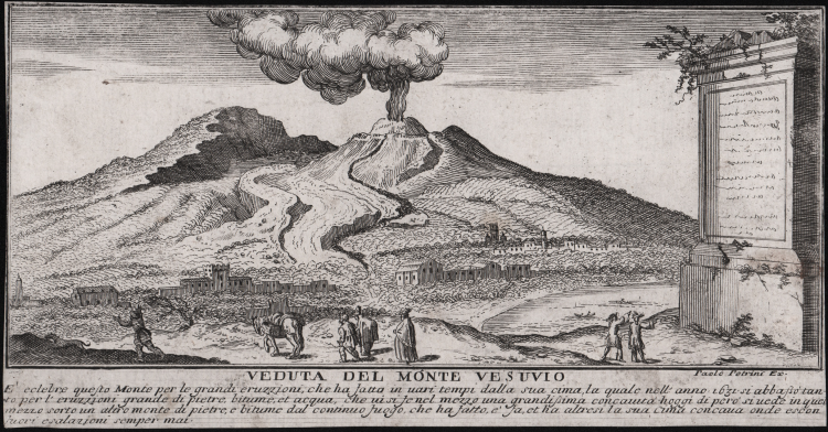
Originally produced as a "constellation" of views around his own plan of the city of Naples, the prints published by Paolo Petrini in 1718 would contribute even more to fixing, in the minds of tourists and collectors, the places destined to become the stereotypical views that would symbolically represent the city.
Paolo Petrini worked in Naples as an engraver and bookseller between 1692 and 1748, drawing prints from paintings by Lanfranco and Luca Giordano, and maps by Guillaume Sanson and Nicolas de Fer, as well as numerous portraits of illustrious Neapolitan men. He also made an "Atlante Partenopeo" (1700), two engravings for the entrance of Philip V and Cardinal Barberini (1702), a volume on the "Palazzi" (1713) and one on the "Chiese" (1718) of Naples, as well as a view of the city of Naples published in 1698 that aroused a lively echo in foreign publishers. All his work is extremely rare.
Etching, in good condition.
Paolo PETRINI (Attivo a Napoli fine del XVIII secolo)
|
very little is known about Petrini except that for many years he was a publisher and map seller in Naples producine large and small maps often slavishly based on those by Guillaume Sanson and Nicolas de Fer. About 1718 he published a large-scale plan of Naples. All his work is very rare.
1700 Atlante Partenopea
1700 Mappa Mondo Vero Carta
1700 ca. Maps of the wolrd and continents (wall maps)
|