Oceani occidentalis seu terrae Novae Tabula
Reference: | S43122 |
Author | Laurent FRIES |
Year: | 1522 ca. |
Zone: | Atlantic Ocean |
Printed: | Vienne |
Measures: | 535 x 395 mm |
Reference: | S43122 |
Author | Laurent FRIES |
Year: | 1522 ca. |
Zone: | Atlantic Ocean |
Printed: | Vienne |
Measures: | 535 x 395 mm |
Description
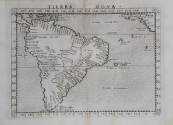
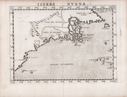
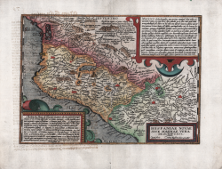
Fine example of Lorenz Fries reduced version of Waldseemuller's map of 1513, which is often referred to as The Admiral's map.
The present example is from the 1541 edition of the Ptolemy's Geographia edited by Fries.
The Waldseemuller prototype was the first printed atlas map to focus on the New World. Waldseemuller's map is preceded only by the small map of the Spanish Main by Peter Martyr in Seville, 1511, which is virtually unobtainable. Fries supplements the work of Waldseemuller with an inscription about Columbus not found in the 1513 version of the map and adds vignettes of Indians and a possum, which he borrowed from Waldseemuller's World Map of 1516.
The first edition of Ptolemy's Geographia edited by Fries was published in Strasbourg in 1522, with maps that were copied and re-engraved from those of Martin Waldseemüller of the 1520 edition of Ptolemy and text edited by Pirckheimer. In 1525 a second edition was printed in Strasbourg. At the death of Fries and Gruninger, the plates were purchased by the brothers Melchior and Gaspar Treschel, who printed a third edition in Lyon in 1535. For the text, the two editors used the supervision of Michael Servetus, who edited Pirckheimer's text. Finally, in 1541, Gaspare Treechsel published in Vienne, in the Dauphiné, this fourth edition, again with Servetus' text. In this edition, compared to the first edition of Strasbourg in 1522, the text underwent numerous changes, corrections and additions, but the wood-blocks were not changed.
“In 1522 Laurent Fries published an edition of Ptolemy's Geography in which virtually all of the maps, including this one, were reduced versions of Waldseemüller's, 1513. Some of the more notable differences are the Columbus name PARIAS found in North America, misplaced from South America, the addition of a Spanish flag over Cuba, and a scene in South America depicting cannibals and an opossum both of which had been reported by Vespucci. The last map is taken directly from Martin Waldseemüller's great twelve sheet Carta Marina of the world, 1516. Here also the TERRA INCOGNITA has been replaced by TERRA NOVA, and the reference to America's discovery by Columbus is repeated. A large area of text below Hispaniola contains a description of that island's location, its discovery by Columbus, and its products. The title appears in a scroll across the top of the map, and is not present in any of the following editions. The latitude markings are now corrected and more legible.
There were further editions published in Strasbourg 1525, Lyon 1535, and Vienne in the Dauphiné 1541. The last two editions were published by Michael Servetus who was burned alive for heresy. On the orders of Jean Calvin copies of this book were destroyed. The text on the reverse of the map in the last two editions, ends with a protest against the use of the name 'America' for the New World: Toto itaque, quod ajunt, aberrant coelo qui hanc continentem Americam nuncupari contendunt, cum Americus multo post Columbum eandem terram adierit, nec cum Hispanis ille, sed cum Portugallensibus, ut suas merces commutaret, eo se contulit.' To identify the editions you can use the title printed on the reverse of the map as follows:
1522 TABVLA TER. NOVAE
1525 Oceani occidëtalis Seu Terre Noue TABVLA
1535 OCEANI OCCIDENTALIS SEV TERRAE NOVAE TABVLA
1541 Tabula terræ nouæ" (Burden "The Mapping of North America", p. 5).
Woodcut, finely colored by hand, in excellent condition.
Bibliografia:
Burden "The Mapping of North America", pp. 5-7, n. 4.
Lorenz (Laurent) Fries was born in Alsace in about 1490. He studied medicine, apparently spending time at the universities of Pavia, Piacenza, Montpellier and Vienna. After completing his medical studies, , Fries worked as a physician in several places, before settling in Strassburg, in about 1519. In Strassburg, Fries met the Strasbourg printer and publisher Johann Grüninger, an associate of the St. Die group of scholars formed by, among others, Walter Lud, Martin Ringmann and Martin Waldseemuller.From 1520 to 1525, Fries worked with Gruninger as a cartographic editor, exploiting the corpus of material that Waldseemuller had created. Fries' first venture into mapmaking was in 1520, when he executed a reduction of Martin Waldseemuller's wall-map of the World, published in 1507. Next Fries’ project was a new edition of the Geographia of Claudius Ptolemy, which was published by Johann Koberger in 1522. Fries evidently edited the maps, in most cases simply producing a reduction of the equivalent map from Waldseemuller's 1513 edition of the Geographie Opus Novissima, printed by Johann Schott. Fries also prepare three new maps for the Geographie: maps of South-East Asia and the East Indies, China and the World, but the geography of these derives from Waldseemuller's world map of 1507. The 1522 edition of Fries work , now very rare, was not commercially successful. In 1525, an improved edition was issued, from the notes of Johannes Regiomontanus. After Grüninger's death in 1531, the business was continued by his son Christoph, who seems to have sold the materials for the Ptolemy to two Lyon publishers, the brothers Melchior and Gaspar Trechsel, who published a joint edition in 1535, before Gaspar Trechsel published an edition in his own right in 1541.
|