| Reference: | S45975 |
| Author | Rigobert BONNE |
| Year: | 1773 |
| Zone: | America |
| Printed: | Paris |
| Measures: | 500 x 360 mm |
| Reference: | S45975 |
| Author | Rigobert BONNE |
| Year: | 1773 |
| Zone: | America |
| Printed: | Paris |
| Measures: | 500 x 360 mm |
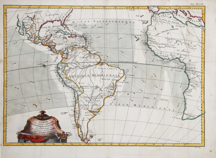
This map is roughly centered on South America, but includes most of Africa, the southern part of North America and the West Indies. Arrows in the ocean depict the directions of the currents or prevailing winds. There is a fair amount of detail in Central and South America. Decorated with a nice title cartouche.
Interior details are relatively sparse in this chart by Rigobert Bonne, as its emphasis is primarily on the seaborne economy of the region. Prevailing winds, critical to maritime commerce, are displayed throughout the Atlantic, including the doldrums in parts of the Caribbean and off the coast of Africa. These constant winds contributed directly to the development of what came to be known as the “Triangular Trade” between the coasts of the Americas, Europe and West Africa, and were thus known as “trade” winds. Generally speaking, the “triangle” involved the exchange of European textiles and manufactured goods for slaves in Africa, which were then transported to plantations across the Atlantic. There, loads of sugar, cotton and tobacco would be shipped back to Europe, completing the cycle of human enslavement and commensurate profits.
Map taken from Raynall, Guillaume-Thomas (1713-1796) Atlas portatif pour servir à l’intelligence de l’histoire philosophique et politique des établissemens et du commerce des Européens dans les deux Indes. Amsterdam: Ernest van Harrevelt and Daniel Jean Changuion, 1773.
Rigobert Bonne (1727-1795) was one of the most important cartographers of the late 18th century. In 1773 he succeeded Jacques Bellin as Royal Cartographer to France in the office of the Hydrographer at the Depôt de la Marine. Working in his official capacity Bonne compiled some of the most detailed and accurate maps of the period. Bonne's work represents an important step in the evolution of the cartographic ideology away from the decorative work of the 17th and early 18th century towards a more detail oriented and practical aesthetic. With regard to the rendering of terrain Bonne maps bear many stylistic similarities to those of his predecessor, Bellin. However, Bonne maps generally abandon such common 18th century decorative features such as hand coloring, elaborate decorative cartouches, and compass roses. While mostly focusing on coastal regions, the work of Bonne is highly regarded for its detail, historical importance, and overall aesthetic appeal.
Copperplate with fine later hand colour, good condition.
Rigobert BONNE (1727 - 1795 ca.)
|
Rigobert Bonne was born in 1727 in Raucourt, in the Lorraine region of northeastern France. He was not only a cartographer but also a hydrographer who produced both land and nautical maps; he spent much of his career working in the French Hydrographic Office or Dépôt des cartes et plans de la Marine. As Royal Hydrographer, Bonne's main interest was the production of nautical maps, but he also gave to print a considerable number of other works, including maps by other cartographers who were his collaborators. He first came to prominence producing a series of plates for the Atlas Moderne ou Collection De Cartes Sur toutes les parties du Globe Terrestre par Plusieurs Auteurs, edited by Giovanni Antonio Rizzi Zannoni and first published in Paris by Jean Lattré in 1762, and subsequently reprinted-with the addition of numerous plates by other cartographers-until the end of the century. But he is probably best known for later publications, including the Atlas Encyclopedique-in collaboration with Nicholas Desmarest (1725-1805)-as well as for the maps he made for Guillaume Raynal's Atlas de Toutes Les Parties Connues du Globe Terrestre (1780). His maps were often commissioned more for educational and informational purposes than for practical use. In 1773, Bonne's talent was rewarded with the title of "Hydrographe du Roy," succeeding Jacques-Nicolas Bellin. From him took its name the pseudoconic projection, adopted, among other things, for the general map of France.
|