
| Reference: | S46838 |
| Author | Carl Joseph MEYER |
| Year: | 1852 ca. |
| Zone: | North Pole |
| Printed: | Hildburghausen |
| Measures: | 310 x 230 mm |
| Reference: | S46838 |
| Author | Carl Joseph MEYER |
| Year: | 1852 ca. |
| Zone: | North Pole |
| Printed: | Hildburghausen |
| Measures: | 310 x 230 mm |
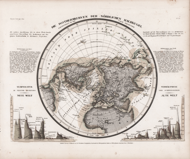
Map of the Northern Hemisphere showing lines of equal temperature (isotherms). In bottom corners are cross section diagram comparisons of mountain height with the New World and Old. These include Bolivia, Quito Mexico within South America as well as the Alleghanies in North America (but with no indication of the Rockies, Alaska, California mountains, etc.). Lower right names Himalayas, Caucasus, the Alps, Scandinavia, etc. Also included are insets of heights of mountain ranges, organized by latitude. Includes explanation.
The nineteenth century witnessed the rise of the systematic investigation of all aspects of Nature. Of particular interest was the determination of how specific phenomena — such as terrestrial magnetism or specific species of plants and animals — varied across the earth’s surface. The drive to measure everything included temperature, of critical importance for the frigid polar regions. Enough measurements had been taken around the northern hemisphere by 1850 to permit the German geographer Joseph Meyer to construct this remarkable map of isotherms (lines of equal temperature), defined in degrees Celsius. He also depicted, across the northern Atlantic Ocean, the southward limit of pack ice.
Taken form Neueste Zeitungs-Atlas für Alte & Neue Erdkunde With a engraved title page, index, and 123 steel engraving outline hand colored maps dated between 1849-1852. These atlas maps were produced in Hildburghausen, Amsterdam, and New York, and are considered some of the most detailed maps produced in the 19th Century. Atlas includes 123 maps of old geography, maps of modern geography, and maps of physical geography. The maps are of the highest Meyer quality, with detail information, showing political and administrative boundaries, cities, towns, canals, forts, roads, railroads, rivers and mountains.
Steel-engraving, contemporary hand-coloring, light foxing, otherwise in very good condition.
Carl Joseph MEYER (Gotha, 1796 – Hildburghausen, 1856)
|
Carl Joseph Meyer (9 May 1796 - 27 June 1856) was a German industrialist and publisher, most noted for his encyclopaedia, Meyers Konversations-Lexikon.
Meyer was born at Gotha, Germany, and was educated as a merchant in Frankfurt am Main. He went to London in 1816, but returned to Germany in 1820 after business adventures and stock speculations fell through. Here he invested in enterprises such as the textile trade (1820–24). Soon after the first steam-hauled railway had started in December 1835, Meyer started to make business plans to start the first railways. He also bought some concessions for iron mining. In 1845 he founded the Deutsche Eisenbahnschienen-Compagnie auf Actien (German Railway Rail joint stock company). Meyer operated very successfully as a publisher, employing a system of serial subscription to publications, which was new at that time. To this end he founded a company, Bibliographisches Institut, in Gotha in 1826. It published several editions of the Bible, works of classical literature, the world in pictures on steel engravings ("Meyers Universum", 1833–61, 17 volumes in 12 languages with 80,000 subscribers all over Europe), and an encyclopaedia, ("Das Grosse Conversations-Lexikon für die gebildeten Stände"; see Meyers Konversations-Lexikon, 1839–55, 52 volumes). His company grew substantially, and in 1828 he moved it from Gotha to Hildburghausen. He became involved in cartography, producing many atlases with steel-engraved maps printed from steel plates, including Meyer's Groẞer Hand-Atlas (1843-1860). After Meyer's death in 1856, his son Herrmann Julius Meyer took over the Bibliographisches Institut, which was at that time struggling financially.
|