
| Reference: | S48064 |
| Author | Gabriel Philippe de La Hire |
| Year: | 1705 ca. |
| Zone: | Celestial Chart |
| Printed: | Paris |
| Measures: | 465 x 475 mm |
| Reference: | S48064 |
| Author | Gabriel Philippe de La Hire |
| Year: | 1705 ca. |
| Zone: | Celestial Chart |
| Printed: | Paris |
| Measures: | 465 x 475 mm |
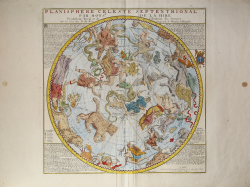
Finely engraved chart of the constellations of the Northern Hemisphere, designed by Gabriel Phillipe de la Hire, one France's most noted astronomers and a member of the Royal Academy of Science.
The plate shows within a circle 42 centimeters in diameter the entire boreal celestial hemisphere. The projection, centered on the ecliptic pole and having as its circumference the zodiacal circle of 'Ecliptic, is concave so the constellations appear as they are seen in the real sky. The grid consists of longitude rays placed every five degrees that are numbered progressively starting over every thirty degrees, notches placed on the outer edge of the Ecliptic allow the individual degree of longitude to be estimated. Latitude can be read by circles placed every five degrees. The expedient of representing equidistant circles of latitude makes it possible to see constellations that are far from the ecliptic pole as they appear in the real sky and thus not dilated. Lines of right ascension are drawn from the equatorial pole every 30 degrees. In addition to the circle of the ecliptic, the line of the Equator, that of the Tropic of Cancer and the two Coluries is drawn.
La Hire's constellation figures are influenced by Johann Bayer's great star atlas (Uranometria, 1603), although La Hire did not use Bayer's system of number stars based upon their brightness. In his treatise on Celestial maps, Warner identifies Sir Edmund Halley as one of the prime sources for the text surrounding the constellations.
The son of a distinguished Paris art professor, Phillipe de la Hire (1640-1718) studied art in Italy before turning to science and mathematics, where he distinguished himself by publishing important treatises on conics. La Hire is best known for his design of charts of the constellations of the Northern and Southern Hemispheres, which were published by Nicolas De Fer, one of France's most important map publishers.
The map was engraved by Hendrick van Loon, who was responsible for a number of the most important French maps of the late 17th and early 18th centuries.
Taken from De Fer L'Atlas curieux ou Le Monde représenté dans des cartes générales et particulières du ciel et de la terre, divisé tant en ses quatre principales parties que par etats et provinces et orné par des plans et descriptions des villes capitales et principales et des plus superbes édifices qui les embelissent comme sont les églises, les palais les maisons de plaisance, les jardins, les fontane, Paris 1702 e 1705.
Copperplate with fine later hand colour, good condition.
Bibliografia
Warner, p. 145-146.
Gabriel Philippe de La Hire (Parigi 1640-1718)
|
A mathematician, son of painter and engraver Laurent de La Hire, he was born in Paris in 1640 and died in 1718. He was a geometer, astronomer, and hydrographer. He taught astronomy and mathematics at the Collège de France, was admitted to the Académie des Sciences in 1678, worked on the Carte de France and performed leveling work to bring water to Versailles. He also made barometric and magnetic observations in various parts of France, where he was responsible for triangulations.
|