

| Reference: | S10734 |
| Author | Gabriel DOPPELMAIER |
| Year: | 1742 |
| Zone: | Celestial Chart |
| Printed: | Nurnberg |
| Measures: | 585 x 500 mm |


| Reference: | S10734 |
| Author | Gabriel DOPPELMAIER |
| Year: | 1742 |
| Zone: | Celestial Chart |
| Printed: | Nurnberg |
| Measures: | 585 x 500 mm |
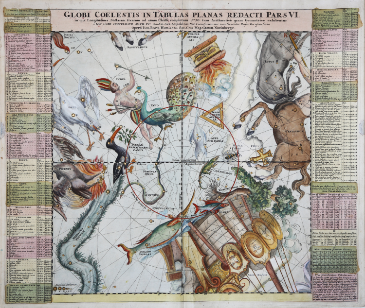
Celestial chart depicting the zodiacal constellations, represented in the classic form of mythological animals.
This is map number 25 of the Atlas Coelestis (1742) by Johann Gabriel Doppelmaier that the professor of mathematics at the Aegidien Gymnasium in Nuremberg, referring in part to the work of Pardies, wrote around 1720 on behalf of the printing house founded in the same city in 1702 by cartographer Johann Baptist Homann.
The map, the sixth of six that together reproduce the entire starry vault, is square with 43.4 cm side, represents the constellations contained in the southern hemisphere up to 45 ° south declination. The gnomonic projection is concave, i.e. geocentric, and the stars, divided into graded classes of six magnitudes, are positioned by calculating the precession of the equinoxes for the year 1730, are identified by letters of the Latin alphabet, the succession begins again for each constellation and corresponds to the list positioned to the right and left of the chart where, for each star, we find the coordinates in latitude and longitude, the magnitude and the description of the anatomical position in the mythological character. In three boxes are reported the corrections to be made to the longitudes to take into account the phenomenon of precession of the equinoxes between 1700 and 1760. A last box gives indications to use the three previous tables. The reference grids allow the calculation of the position of the stars with reference to their right ascension and declination (notches of one degree) but also to their latitude and longitude (lines every 10 degrees). The lines of the equinoxes and solstices, the southern polar circle, the Antarctic pole and the southern ecliptic pole are highlighted.
In addition to the Ptolemaic constellations pertaining to the area are described or drawn the following non-Ptolemaic constellations: Crux, whose stars are listed along with those of the Centaur, Robur Caroli and Phoenix, Grus, Indus, Pavo, Toucan, Dorado, Hydrus, Piscis Volans, Chamaleon, Apis Indica, Triangulum Australe , Apis, the twelve constellations observed in the last years of the sixteenth century by navigators P. D. Keyser and F. de Houtman during one of their voyages in the Indian Ocean and who had designed them to distribute the 135 stars observed and cataloged with the precision of about two degrees.
Copper engraving, contemporary coloring with fine later addition, in excellent condition.
|
Whitfield, Mapping of the Heavens, pp. 93, 96-97. Tooley, R.V., Maps and Map-Makers. p. 27; Kanas, Nick. 2009. Star Maps: History, Artistry, and Cartography. Springer/Praxis.
|
Gabriel DOPPELMAIER (1677-1750)
|
Doppelmayr’s best-known astronomical work is his Atlas Coelestis in quo Mundus Spectabilis et in eodem Stellarum omnium Phoenomena notabilia, circa ipsarum Lumen, Figuram, Faciem, Motum, Eclipses, Occultationes, Transitus, Magnitudines, Distantias, aliaque secundum Nic. Copernici et ex parte Tychonis de Brahe Hipothesin. Nostri intuitu, specialiter, respectu vero ad apparentias planetarum indagatu possibiles e planetis primariis, et e luna habito, generaliter celeberrimorum astronomorum observationibus graphice descripta exhibentur, cum tabulis majoribus XXX, published in 1742 by the heirs of Homann in Nuremberg. In this atlas, Doppelmayr collected most of the astronomical and cosmographical plates which he had prepared over the years for the Homann publishing firm and which had appeared in several of their atlases. These earlier atlases allow us to infer approximate dates for the design and preparation many of Doppelmayr’s cosmographical plates.
The earliest ones are plates 2 and 11 as they were already included in Homann’s first atlas, the Neuer Atlas (Nuremberg, 1707). Plates 3 and 7 to 10 were first published in Homann’s Atlas von hundert Charten (Nuremberg, 1712), whereas plates 1, 4 and 15 to 25 can be dated between 1716 and 1724 as they were not included in Homann’s Grossen Atlas (Nuremberg, 1716), but are mentioned in Hager’s list of plates sold by Homann at his death in 1724.
|
|
Whitfield, Mapping of the Heavens, pp. 93, 96-97. Tooley, R.V., Maps and Map-Makers. p. 27; Kanas, Nick. 2009. Star Maps: History, Artistry, and Cartography. Springer/Praxis.
|
Gabriel DOPPELMAIER (1677-1750)
|
Doppelmayr’s best-known astronomical work is his Atlas Coelestis in quo Mundus Spectabilis et in eodem Stellarum omnium Phoenomena notabilia, circa ipsarum Lumen, Figuram, Faciem, Motum, Eclipses, Occultationes, Transitus, Magnitudines, Distantias, aliaque secundum Nic. Copernici et ex parte Tychonis de Brahe Hipothesin. Nostri intuitu, specialiter, respectu vero ad apparentias planetarum indagatu possibiles e planetis primariis, et e luna habito, generaliter celeberrimorum astronomorum observationibus graphice descripta exhibentur, cum tabulis majoribus XXX, published in 1742 by the heirs of Homann in Nuremberg. In this atlas, Doppelmayr collected most of the astronomical and cosmographical plates which he had prepared over the years for the Homann publishing firm and which had appeared in several of their atlases. These earlier atlases allow us to infer approximate dates for the design and preparation many of Doppelmayr’s cosmographical plates.
The earliest ones are plates 2 and 11 as they were already included in Homann’s first atlas, the Neuer Atlas (Nuremberg, 1707). Plates 3 and 7 to 10 were first published in Homann’s Atlas von hundert Charten (Nuremberg, 1712), whereas plates 1, 4 and 15 to 25 can be dated between 1716 and 1724 as they were not included in Homann’s Grossen Atlas (Nuremberg, 1716), but are mentioned in Hager’s list of plates sold by Homann at his death in 1724.
|