

| Reference: | S46195 |
| Author | Antonio Hermil |
| Year: | 1767 |
| Zone: | Pozzuoli |
| Printed: | Naples |
| Measures: | 570 x 455 mm |


| Reference: | S46195 |
| Author | Antonio Hermil |
| Year: | 1767 |
| Zone: | Pozzuoli |
| Printed: | Naples |
| Measures: | 570 x 455 mm |
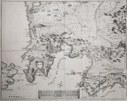
Very rare topographic map of the Phlegraean Fields. Extends from the Torre and Lago di Patria in the north to include the northern part of Naples in the south, where Posillipo, Mergellina, and Castel dell'Ovo are represented. Outlined with particular care is the promontory of Cape Miseno and the eastern coasts of the island of Procida.
The map is oriented with north, northwest at the top, departing from the representative model in use, derived from Mario Cartaro's map of 1584, with southwest at the top.
Antonio Hermil was a bookseller of French descent who settled in Naples in the second half of the 18th century. It is known of him that he had a bookshop in Via Toledo; some of his works bear the address Si vendono nelle librerie di Antonio Hermil vicino alla Concezione di Toledo. He came from a family of publishers and booksellers originally from Briancon who had settled in Turin.
Etching, printed on contemporary laid paper, trimmed at marginal line, in very good condition. "Traveling" example with numerous paper folds.
Antonio Hermil (attivo a Napoli nella seconda metà del XVIII secolo)
Antonio Hermil (attivo a Napoli nella seconda metà del XVIII secolo)