| Reference: | s19803 |
| Author | Giovanni Antonio MAGINI |
| Year: | 1597 ca. |
| Zone: | Ischia |
| Printed: | Bologna |
| Measures: | 540 x 420 mm |
| Reference: | s19803 |
| Author | Giovanni Antonio MAGINI |
| Year: | 1597 ca. |
| Zone: | Ischia |
| Printed: | Bologna |
| Measures: | 540 x 420 mm |
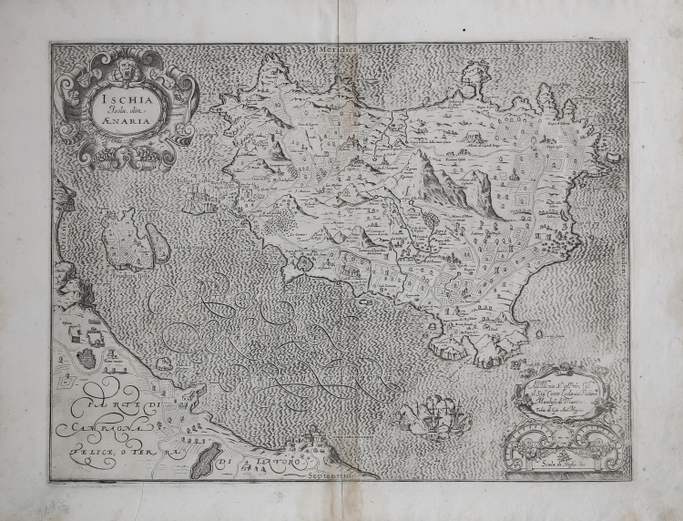
In the cartouche at upper left is the title ISCHIA Isola, olim AENARIA. Bottom right cartouche with dedication To Ill.mo mio S.r et P[at]ron[us] Col.mo il Sig.r Conte Lodovico Fachenetti Marchese di Viairino. Fabio di Gio. Ant.o Magini and the graphic scale Scale of Mile (2 miles equal to mm 91). Orientation in the four sides in the center with the names of the cardinal points Septentrio, Meridies, Oriens, Occidens, north at the bottom.
Magini's map of the island of Ischia has as its main sources the work of Giulio Iasolino engraved by Mario Cartaro (1586) and notions provided by Nicola Stigliola and Mario Cartaro himself.
Map taken from L'Italia edited by Fabio Magini, published in Bologna in 1620, three years after the untimely death of his father.
“Giulio Iasolino è medico e scienziato calabrese, originario di Monteleone Calabro, e autore di diversi trattati di anatomia. Il De rimedi costituisce il suo lavoro più importante, al quale è legata la sua fama. L’opera tratta dell’antichità d’Ischia e, mediante le testimonianze di numerosi antichi scrittori greci e latini, dimostra come in epoca antica i bagni di quest’isola fossero d’uso comune e celebratissimi. L’opera fu pubblicata per la prima volta a Napoli nel 1588 da Giuseppe Cacchi. In realtà, Iasolino aveva completato un manoscritto in latino sull’isola e le sue sorgenti già nel 1582, ma le sue nobili pazienti lo persuasero a pubblicarlo in italiano, per cui passarono altri sei anni prima che l’opera vedesse la luce, dopo essere stata privata delle questioni estremamente tecniche ed integrata con nuovi capitoli riguardanti la descrizione topografica dell’isola e questioni di carattere generale. Nel 1586, Mario Cartaro delineò la carta dell’isola, sulle precise indicazioni fornitegli da Iasolino. La carta, tuttavia, è presente in pochissimi esemplari del libro, probabilmente poiché stampata separatamente a Roma due anni prima della pubblicazione del volume. Il lavoro del Cartaro, prototipo della cartografia dell’isola, venne subito ripreso da Abraham Ortelius per la tavola che pubblica nel Theatrum Orbis Terrarum del 1590” (cfr. S. Bifolco/F. Ronca, Cartografia e Topografia Italiana del XVI secolo, p. 2064).
Composed of a short descriptive text of only 24 pages, the work is accompanied by 61 maps of the peninsula, and is the first example of an Italian atlas. The work is entirely by the hand of Giovanni Antonio Magini, who began the realization of the maps in 1594 or so; the first dated map (1595) the map of the territory of Bologna. All the maps were printed before 1620, in their provisional drafts, later corrected and updated for the final edition. For the realization of the plates Magini used two of the most famous engravers of the time: the Belgian Arnoldo Arnoldi and the English Benjamin Wright.
Copperplate, in good condition.
Giovanni Antonio MAGINI (1555 - 1617)
|
Giovanni Antonio Magini was born in Padua in 1555, dedicating himself to the study of astronomy from an early age. In 1588 the Senate of Bologna appointed him Lecturer of Astronomy at the local University, choosing him instead of Galileo Galilei. His friendship with the Duke of Mantua, Vincenzo Gonzaga, helped Magini in his quest to obtain cartographical material for map-making from the various sovereigns ruling the different Italian states at that time. Because of Magini's early death in 1617, this effort was made famous by his son Fabio when he published the atlas "L'Italia" in Bologna in 1620. This is the first example of an Italian atlas and is made up of 24 pages of descriptive text and 61 maps of the Italian peninsula. Although this work was published posthumously, it can be entirely ascribed to Magini. He began drawing this maps around 1594, with the one depicting Bologna and its surrounding territories being the first. They were all printed before 1620 in draft editions which were then revised and updated for the final version. These draft proofs are extremely rare, although sometimes available for sale, and exhibit substantial differences in respect to the maps finally included in the atlas. Two of the most famous engravers of the time, Arnoldo Arnoldi and the englishman Benjamin Wright, were entrusted by Magini to engrave the plates. As we shall see in the presentation of the separate maps, they derive from different sources, both known and unknown, and therefore represent the result of an original work of critical analysis and compilation. This atlas had an important influence on the cartography of the italian peninsula for the following two centuries, beginning from Ortelius and going on to the principal dutch cartographers and editors.
|