

| Reference: | CO-463 |
| Author | Franz Johann von REILLY |
| Year: | 1798 ca. |
| Zone: | Central Italy |
| Printed: | Wien |
| Measures: | 305 x 260 mm |


| Reference: | CO-463 |
| Author | Franz Johann von REILLY |
| Year: | 1798 ca. |
| Zone: | Central Italy |
| Printed: | Wien |
| Measures: | 305 x 260 mm |
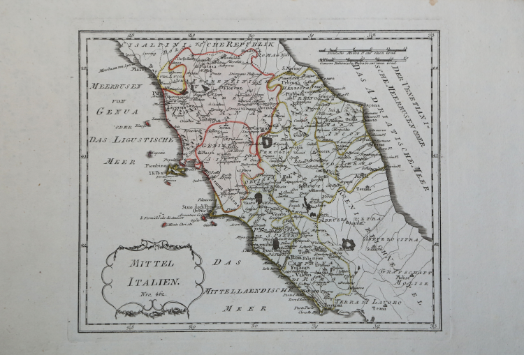
Published in Vienna by Franz Johann Joseph von Reilly in Schauplatz der fünf Theile der Welt mit beständiger Rücksicht auf die besten Originalwerke in drey Theile zusammengetragen von einer Gesselschaft Geographen nach zu Büschings Grosser Erdbeschreibung.
Reilly (1766-1820) published the Atlas at the rate of one map per week for 17 years from June 1789 to July 1806, producing, in total, some 830 maps of Europe. A third part of the atlas was planned to cover the rest of the world, but was never published.
As can be deduced from the title of the Atlas in which the map was first published, the author of the drawing was the German cartographer Anton Friederich Büschings and the engraver was Ignaz Albrecht. The Atlas was published by the Viennese art dealer Franz Johann Joseph von Reilly (1766-1820) who produced at least 830 maps between 1789 and 1806 - right in the period of the Napoleonic campaigns, when the borders were rather labile - and those concerning Italy were published between August 1797 and June 1799.
Etching, printed on blue paper and with editorial colouring, in excellent condition.
“La graduazione ai margini, di 4' in 4', va da 41° 08' a 44° 20' lat. e da 27° 16' a 33° long. Manca di orientazione; le scale sono in miglia tedesche e italiane. Il titolo si legge in una cartella, con semplice cornice, posta in basso a sinistra. La carta ha dimensioni all'incirca identiche alla precedente, ma comprende tutta (o quasi) l'Italia Centrale e una buona porzione del Regno di Napoli fino al Golfo di Gaeta.
Confrontata opportunamente con la carta del solo Stato della Chiesa dello stesso autore si nota che, pur nella semplificazione (se non eliminazione) di alcuni elementi in questa presenti, aggiunge altri toponimi di centri abitati - vedi il caso della costa marchigiana a sud di Ancona - facendosi per altro più precisa nella localizzazione degli stessi; per questo aspetto, insomma, la tavola pare essere a correzione e integrazione della precedente, specie per il territorio dello Stato Pontificio di cui si riportano anche i confini interni ben distinguendo l'Umbria dal Territorio di Perugia L'area rappresentata risulta estesa in latitudine un poco più a nord. "M. Adriatico" e "Golfo di Venezia" come in molte altre carte settecentesche (ma anche del secolo precedente) risultano quali semplici sinonimi (nell'Atlas Minor mercatoriano, ad es., la costa anconetana è fronteggiata dalla scritta "Golfo di Venezia", ma assai di frequente è dato leggere "Golfo di Venezia sive Mare Adriaticum", "Golfe de Venise dit autre Mer Adriatique" o, come in questo caso, "Der Venetianische Meerbusen oder Das Adriatische Meer"). La datazione della carta è consentita, seppur con approssimazione, dalla non-rappresentazione della Romagna nello Stato della Chiesa a seguito della nuova realtà politica prodottasi in Italia dopo la costituzione della Repubblica Cisalpina (giugno 1797)” (cfr. "Le antiche terre del Ducato di Spoleto", p. 226).
Acquaforte, coloritura editoriale, in ottimo stato di conservazione.
|
F. Ronca e A. Sorbini (a cura di) "Le antiche terre del Ducato di Spoleto", p. 226, 99.
|
Franz Johann von REILLY (Vienna 1766 - 1820)
|
He was a Viennese art dealer who in his early twenties turned to map publishing, and between the years 1789 and 1806 produced a total of no less than 830 maps. His Schauplatz…der Welt (World Atlas) in fact covered only maps of Europe, whilst the Grosser Deutscher Atlas also included maps of other continents and was, therefore, the first World Atlas produced by an Austrian.
1789-1806 Schauplatz der funf Theile der Welt
1794-96 Grosser Deutscher Atlas
|
|
F. Ronca e A. Sorbini (a cura di) "Le antiche terre del Ducato di Spoleto", p. 226, 99.
|
Franz Johann von REILLY (Vienna 1766 - 1820)
|
He was a Viennese art dealer who in his early twenties turned to map publishing, and between the years 1789 and 1806 produced a total of no less than 830 maps. His Schauplatz…der Welt (World Atlas) in fact covered only maps of Europe, whilst the Grosser Deutscher Atlas also included maps of other continents and was, therefore, the first World Atlas produced by an Austrian.
1789-1806 Schauplatz der funf Theile der Welt
1794-96 Grosser Deutscher Atlas
|