
| Reference: | S46177 |
| Author | Guillaulme DE L'ISLE |
| Year: | 1720 |
| Zone: | China |
| Printed: | Venice |
| Measures: | 180 x 145 mm |
| Reference: | S46177 |
| Author | Guillaulme DE L'ISLE |
| Year: | 1720 |
| Zone: | China |
| Printed: | Venice |
| Measures: | 180 x 145 mm |
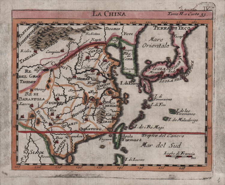
A small map of China published in De Chevigny, La scienza delle persone di corte, di spada, e di toga, del signore di Chevigni, accresciuta di vari trattati da H. P. De Limiers dottore di legge, ed arricchita di molte figure in rame (Venice: Stamperia Baglioni, 1720).
This map follows the original 1710 work by Chevingny and De L’Isle, published by Chatelain in Amsterdam. It appears coarser than the original, for example, the names of the seas were written in normal typographical characters, neglecting the elegant cursive typeface used by Delisle in 1710 for the seas. It also introduced some spelling mistakes: TOKIEU instead of FOKIEN for the province of Fujian and Koan f. (in the original it was Hoam Flu.) for the Yellow River.
The success of Sieur de Chevigny's encyclopaedic-didactic work (Amsterdam, 1707) convinced a Venice publisher to bring out an Italian translation by Selvaggio Canturani, accompanied by maps that appear in the second edition attributed to the French cartographer Guillaume Delisle. Selvaggio Canturani was the usual pseudonym used by a Venetian theologian, Arcangelo Agostini (c.1660-1746), best known for his translations from French. The Stamperia Baglioni (Baglioni Firm) in Venice was founded in 1598 by Tommaso Baglioni, who published the works of Galileo Galilei, and the firm continued its publishing activities without interruption until 1850. In 1717 the Baglioni family became part of the patriciate of Venice, a unique example of this honour being given to simple printers, even though they were no longer perceived as artisans but rather as heads of commercial enterprises. The Baglioni firm published reprints in 1734 and 1742, and another edition was printed in Naples in 1782 by the publisher Cervone, with a different copperplate.
“This map and a later print in 1725 follows the original 1710 work. It appears coarser than the original, for example, the names of the seas were written in normal typographical characters, neglecting the elegant cursive typeface used by Delisle in 1710 for the seas. It also introduced some spelling mistakes: TOKIEU instead of FOKIEN for the province of Fujian and Koan f. (in the original it was Hoam Flu.) for the Yellow River.
The success of Sieur de Chevigny's encyclopaedic-didactic work (Amsterdam, 1707) convinced a Venice publisher to bring out an Italian translation by Selvag- gio Canturani, accompanied by maps that appear in the second edition attribut- ed to the French cartographer Guillaume Delisle. Selvaggio Canturani was the usual pseudonym used by a Venetian theologian, Arcangelo Agostini (c.1660-1746), best known for his translations from French
The Stamperia Baglioni (Baglioni Firm) in Venice was founded in 1598 by Tom- maso Baglioni, who published the works of Galileo Galilei, and the firm contin- ued its publishing activities without interruption until 1850. In 1717 the Baglioni family became part of the patriciate of Venice, a unique example of this honour being given to simple printers, even though they were no longer perceived as artisans but rather as heads of commercial enterprises (Infelise 1991, 133-6; CERL Thesaurus, cni00061673). The Baglioni firm published reprints in 1734 and 1742, and another edition was printed in Naples in 1782 by the publisher Cervone, with a different copperplate.“ (Caboara "Regnum Chinae", p. 455)
Copperplate, fine later hand colour, good condition.
Bibliografia:
Caboara "Regnum Chinae", pp. 455-456, n. 117.
Guillaulme DE L'ISLE (1675 - 1726)
|
vershadowed by his more famous son, Guillaume.
Guillaume De L’Isle, (1675-1726) Premier Geographe to the French king, was probably the leading map-maker of the period. His work was important as marking a transition from the maps of the Dutch school, which were highly decorative and artistically-orientated, to a more scientific approach, which reduced the importance given to the decorative elements, and emphasized the scientific base on which their maps were constructed, out of which the modern school of cartography emerged. He was prominent in the recalculation of latitude and longitude, based on the most up-to-date celestial observations, and his major contribution was in collating and incorporating this information in his maps, setting a new standard of accuracy, quickly followed by many of his contemporaries, including the Dutch firm of Covens and Mortier.
Having learnt geography from his father, it is said that at the age of eight or nine he could draw maps to demonstrate ancient history. He studied mathematics and astronomy under J.D. Cassini, where he received the grounding in scientific cartography, that is the hallmark of his work.
His first atlas was published in about 1700, in 1702 he was elected a member of the Academie Royale des Sciences, and in 1718 became Premier Geographe du Roi. His maps of the newly explored parts of the world reflect the most up-to-date information available and did not contain fanciful detail in the absence of solid information.
After his death in 1726 his business was continued by his nephew Philippe Buache, and subsequently by J. Dezauche.
Joseph Nicholas De L’Isle (1688-1768), Guillaume’s brother, became a friend of Peter the Great and supplied him with information on the Russian Empire. He stayed in Russia for twenty-two years and was in charge of the Royal Observatory in St. Petersburg, returning to France in 1747, taking with him much of the material he had access to, particularly relating to explorations along the northern Pacific coasts of Russia and America, which he subsequently published. The Atlas Russicus was published in 1747 and contained twenty maps.
Simon Claude De L’Isle (1675-1726) was a historian. It is curious to note that he was born and died in the same years as his elder brother Guillaume.
|