
| Reference: | S46171 |
| Author | Jacques Nicolas BELLIN |
| Year: | 1748 ca. |
| Zone: | China |
| Printed: | Venice |
| Measures: | 395 x 285 mm |
| Reference: | S46171 |
| Author | Jacques Nicolas BELLIN |
| Year: | 1748 ca. |
| Zone: | China |
| Printed: | Venice |
| Measures: | 395 x 285 mm |
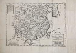
Italian edition of Jacques Nicolas Bellin's map of China, Korea and neighboring regions of Central Asia.
Between 1708 and 1717 Jesuit missionaries established in China directed a comprehensive topographical study of the Chinese empire at the request of the emperor. The maps from this work were taken from China to Paris, where Jean-Baptiste Bourguignon d'Anville (1697-1782), an eminent cartographer, geographer and map collector, used them to compile his atlas on the region.
The Italian edition presented here, which shows China, Korea and the neighboring regions of Central Asia, then called Tartary, is an adaptation of one of D'Anville's maps.
Published in the translation of Antonine de Prevost d'Exile's Histoire generale des voyages.
Jacques Nicolas Bellin (1703 - March 21, 1772) was born in Paris. He was a hydrographer for the French Hydrographic Office, a member of the Académie de Marine and the Royal Society of London. In his 50-year career he produced a large number of charts of special interest to the Ministère de la Marine.
Etching, usual editorial folds, otherwise good condition.
Jacques Nicolas BELLIN (1703 - 1772)
|
Jacques-Nicolas Bellin (1703 - 1772) was one of the most important cartographers of the 18th century.
With a career spanning some 50 years, Bellin is best understood as transitional mapmaker spanning the gap
between 18th and early 19th century cartographic styles. His long career as Hydrographer and Ingénieur
Hydrographe at the French Dépôt des cartes et plans de la Marine resulted in hundreds of high quality
nautical charts of practically everywhere in the world. Bellin's work focuses on function and accuracy
tending in the process to be less decorative than the earlier 17th and 18th century cartographic work. In
addition to numerous maps and charts published during his lifetime, many of Bellin's maps were updated
(or not) and published posthumously. He was succeeded as Ingénieur Hydrographe by his student, also a prolific and influential cartographer, Rigobert Bonne.
|