
| Reference: | S46067 |
| Author | Joannes Lhuilier |
| Year: | 1669 ca. |
| Zone: | Heraklion |
| Printed: | Rome |
| Measures: | 535 x 390 mm |
| Reference: | S46067 |
| Author | Joannes Lhuilier |
| Year: | 1669 ca. |
| Zone: | Heraklion |
| Printed: | Rome |
| Measures: | 535 x 390 mm |
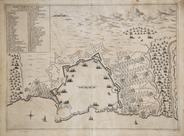
Very rare map of the siege of Candia engraved-and probably published-by Johannes Lhuilier.
The work is not found in major graphic collections, and we have had no records of other examples.
In the upper right, within inset, the title VERA PIANTA DI CANDIA ASSEDIATA DAI TURCHI. Dissegnata da Dioniso Spada, e Intagliata da Lhuilier in Roma. A numerical legend of 66 cross-references follows. Below is the orientation with a wind rose, with North at the bottom.
Oblique view from above and map of the city of Candia, besieged by the Turks from May 1, 1648, to September 27, 1669, and defended by the Venetian forces of Captain General Francesco Morosini (Feb. 26, 1619-Jan. 1694), who eventually surrendered the city and ceded Crete to the Ottomans in 1669.
This print is very close in style and content to another view-map combination entitled CITTA DI CANDIA ASSEDIATA, published in 1651 as plate 25 of Marco Boschini's Il regno tutto di Candia. Boschini's 1651 siege map has additional details suggesting that it shows a slightly later phase of the siege.
The prototype for both, however, is an anonymous map dated 1648, probably of the Italian school (see McDonald No. 3023, describing the Royal Collection Trust example RCIN 723080).
The event was so important that the printers of the time, especially those in Rome, printed a rich series of documents of the siege. In particular, the French-born engraver and publisher Francois Collignon (c. 1610 - 1687), author of at least 10 plates on the siege of Candia, was very active in this regard.
This plate by Johannes Lhuilier is undated. Lhuilier, another French-born engraver active in Rome, worked at the printing house of Giovanni Giacomo de Rossi between 1660 and 1670. For the publisher he had carved several maps for the Mercurio Geografico. However, the lack of an editorial imprint suggests that in this case Lhuilier was also the printer. For that matter, the plate is not mentioned in the De Rossi Indice, the Roman printer's catalog. This may explain its very great rarity.
Etching, printed on contemporary laidpaper, with margins, in very good condition. Very rare.
Bibliografia
cfr. Mark McDonald, The Print Collection of Cassiano dal Pozzo. Part II, Architecture, Topography and Military Maps, 3 vols, London 2019, cat. no. 3203; cfr. J. Ostwald, Vauban under siege: engineering efficiency and martial vigour in the War of the Spanish Succession, Leiden 2007.
Joannes Lhuilier(attivo a Roma verso il 1660/70)
Joannes Lhuilier(attivo a Roma verso il 1660/70)