
| Reference: | S20740 |
| Author | Jacques Nicolas BELLIN |
| Year: | 1757 ca. |
| Zone: | East Indies |
| Printed: | Paris |
| Measures: | 300 x 26 mm |
| Reference: | S20740 |
| Author | Jacques Nicolas BELLIN |
| Year: | 1757 ca. |
| Zone: | East Indies |
| Printed: | Paris |
| Measures: | 300 x 26 mm |
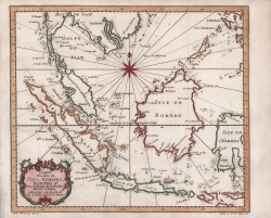
Attractive map of the East Indies by Bellin. The map covers from Siam or modern day Vietnam south to include the western portion of the Lesser Sunda Islands. Depicts the islands of Malay (Malacca), Singapore, Borneo, Sumatra, Java, and part of Celebes (Sulawesi). There is impressive detail throughout the coastline, with little inland information. Singapore remains unidentified, but several other lesser islands are noted including Tioman Island (Poulo ou I. Timon) and Penang. A beautifully engraved title cartouche adorns the lower left of the map. This map was issued in Antoine-Francois Prevost's Historie General des voyages.
The collection, in several volumes, is printed for the first time A Paris: chez Didot, 1746-1753.
The complete work - in 12th - will continue the publications until it reaches, in 1789, a consistency of 80 volumes. A colossal encyclopedic research work carried out by the author, which also deserves credit for having published numerous unpublished stories about the discovery of Australia by the Dutch and reports of journeys across the Pacific, including those of Magellan and Schouten.
The work is accompanied by nearly 300 illustrations of populations, views, and costumes from around the world and by 113 splendid maps, by Jaques-Nicolas Bellin.
Copperplate, fine later hand colour, in good conditions.
Jacques Nicolas BELLIN (1703 - 1772)
|
Jacques-Nicolas Bellin (1703 - 1772) was one of the most important cartographers of the 18th century.
With a career spanning some 50 years, Bellin is best understood as transitional mapmaker spanning the gap
between 18th and early 19th century cartographic styles. His long career as Hydrographer and Ingénieur
Hydrographe at the French Dépôt des cartes et plans de la Marine resulted in hundreds of high quality
nautical charts of practically everywhere in the world. Bellin's work focuses on function and accuracy
tending in the process to be less decorative than the earlier 17th and 18th century cartographic work. In
addition to numerous maps and charts published during his lifetime, many of Bellin's maps were updated
(or not) and published posthumously. He was succeeded as Ingénieur Hydrographe by his student, also a prolific and influential cartographer, Rigobert Bonne.
|