

| Reference: | S36128 |
| Author | Mattheus QUAD |
| Year: | 1592 ca. |
| Zone: | Slovenia, Croatia, Bosnia, Albania |
| Printed: | Cologne |
| Measures: | 268 x 185 mm |


| Reference: | S36128 |
| Author | Mattheus QUAD |
| Year: | 1592 ca. |
| Zone: | Slovenia, Croatia, Bosnia, Albania |
| Printed: | Cologne |
| Measures: | 268 x 185 mm |
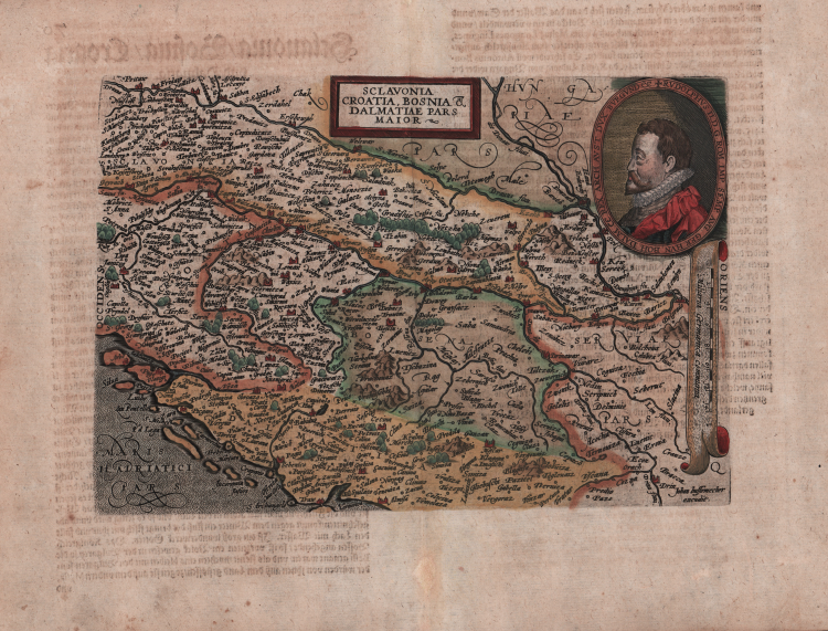
Scarce early map of the region from Slovenia to Serbia, engraved by Johann Bussemacher and published by Quad.
The map is centered on Croatia and Bosnia Herzogovina, extending south to Split on the coastline and east to Belgrade.
Includes a large portait of Rudolf II, the Holy Roman Emperor (1576-1612), King of Hungary and Croatia (as Rudolf I, 1572-1608), King of Bohemia (1575-1608/1611) and Archduke of Austria (1576-1608).
He was a member of the House of Habsburg. Described by a noted contemporary as "the greatest art patron in the world".
From Fasciculus Geographicus Complectens Praeciparum Totius orbis Regionum tabulas circiter centum. una cum earundum Enarrationibus, Cologne, J. Bussemacher, 1608.
Matthaus Quad was a German cartographer based in Cologne. The map was engraved by Johannes Bussemacher and appeared in several Geographical works published by Quad and Bussemacher at the end of the 16th and beginning of the 17th century.
Matthias Quad (1557-1613), a map publisher based in Cologne, was trained in the Netherlands by Johannes van Doetecum, who also worked with the De Jodes. Quad used many De Jode maps as a base to which he added additional information and decorations. Quad was best known for his atlases, which were part of the first boom in atlases best characterized by Abraham Ortelius’ Theatrum Orbis Terrarum. In 1592, Quad released an atlas of Europe that had 38 maps. He expanded it in 1594 to 50 maps. In 1600, he expanded the collection of maps further still, this time to 82 maps, and called the atlas, Geographisch Handtbuch. All three were small in size, allowing them to compete as cheaper alternatives to the larger atlases of Ortelius, Mercator, and the De Jodes. Quad released one other atlas, in 1608, with 86 maps, the Fascilus Geographicus.
Etching with fine later hand colour, good condition.
Mattheus QUAD (Deventer 1557 - Colonia 1613)
|
As it often appened then, to escape from Catholic persecution, Protestants, and Matthias Quad among them, used many alias for their work. The most famous used by the artis were C. Eichovius, M. Quadus, M. Quad von Kinckelbach and Konrad Loew. Quad escaped from Holland to Germany in 1587, studied in Heidelberg and afterwards became one of the most prolific artists of the Cartographic School of Cologne, whose activity lasted for 150 years (1570-1620 ca.). The school was basically built up by Flemish and Dutch artists escaping from persecution, among them also Frans Hogenberg, the founder of the school. In 1594 Quad published in Cologne Europae, totius terrarum orbis partis praestantissimae descriptio. In 1596 approximately, and again in Cologne, he published Typus Orbis Terrarum, ad Imitationem Universalis Gerhardi Mercatoris, a world map based on Marcator’s work but in 1600 he published his personal, indipendent world atlas, the Geographisch Handtbuch, which is also the first one published in German. In 1608 a Latin edition was issued, Fasciculus Geographicus, with four unpublished maps engraved by Johann Bussemacher, his collaborator. Due to his multiple alias, his huge production is still to be completely identified. Quad’s maps did not enjoy great success for they were published the same period of Ortelius’ atlases; for that reason, there is not a second edition known of Quad’s work, which makes his first one vary rare and sought-after.
1592 Europae totius orbis terrarium (small folio)
1594 and 1596 re-issued
c.1600 Geographisch handtbuch
1608 maps re-issued in Fasciculus geographicus(small folio)
|