

| Reference: | s33956 |
| Author | John SPEED |
| Year: | 1676 |
| Zone: | France |
| Printed: | London |
| Measures: | 525 x 410 mm |


| Reference: | s33956 |
| Author | John SPEED |
| Year: | 1676 |
| Zone: | France |
| Printed: | London |
| Measures: | 525 x 410 mm |
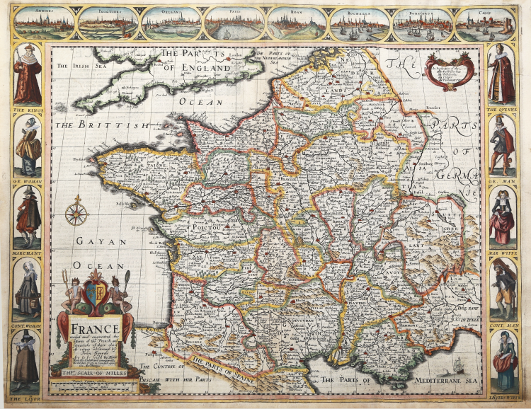
Beautiful carte-a-figures map covers France and displays the various regions, published in A Prospect of the most famous part of the World" - edition of 1676, with Roger Rea's imprint.
The map includes a decorative title cartouche and a key explaining the symbols used to identify various cities and towns.
It is decorated across the top with views of eight cities, Angers, Poitiers, Orleans, Paris, Rouen, La Rochelle, Bordeaux and Calais.
The panels down both sides depict pairs of men and women of the region in period dress.
A description of France in English appears verso.
Copper engraving, hand coloured, in very good condition.
|
John Speed (1552-1629) is the most famous of all English cartographers primarily as a result of The Theatre of the Empire of Great Britaine, the first atlas of the British Isles. The individual maps are the best known and most sought-after of all county maps. They were derived from the best up-to-date sources available; however, Speed did make innovations - introducing town plans, county boundaries, and embellishments such as the coats of arms of local Earls, Dukes, and the Royal Household. The overall effect is to produce very decorative, attractive and informative maps. Speed was also responsible for the first world atlas by an Englishman, The Prospect of the Most Famous Parts of the World (1627). The maps are famed for their borders consisting of local inhabitants in national costume and panoramic vignette views of major cities and towns. An added feature is that regular atlas copies have English text printed on the reverse, giving a charming description of life in the early seventeenth century of the region.
Little is known of Speed's personal life other than that he was born in 1552 the son of a Cheshire tailor who devoted his time to map making. In 1598 he was found a post in the Customs where, with Royal patronage, he was subsidized in map making. Through his work he became a member of such learned societies as the Society of Antiquaries and associated with the likes of William Camden Robert Cotton and William Lambarde. He died in 1629 at the age of seventy-seven.
|
|
John Speed (1552-1629) is the most famous of all English cartographers primarily as a result of The Theatre of the Empire of Great Britaine, the first atlas of the British Isles. The individual maps are the best known and most sought-after of all county maps. They were derived from the best up-to-date sources available; however, Speed did make innovations - introducing town plans, county boundaries, and embellishments such as the coats of arms of local Earls, Dukes, and the Royal Household. The overall effect is to produce very decorative, attractive and informative maps. Speed was also responsible for the first world atlas by an Englishman, The Prospect of the Most Famous Parts of the World (1627). The maps are famed for their borders consisting of local inhabitants in national costume and panoramic vignette views of major cities and towns. An added feature is that regular atlas copies have English text printed on the reverse, giving a charming description of life in the early seventeenth century of the region.
Little is known of Speed's personal life other than that he was born in 1552 the son of a Cheshire tailor who devoted his time to map making. In 1598 he was found a post in the Customs where, with Royal patronage, he was subsidized in map making. Through his work he became a member of such learned societies as the Society of Antiquaries and associated with the likes of William Camden Robert Cotton and William Lambarde. He died in 1629 at the age of seventy-seven.
|