

| Reference: | S7548 |
| Author | Pieter VANDER AA |
| Year: | 1704 ca. |
| Zone: | Friuli |
| Printed: | Leyden |
| Measures: | 385 x 310 mm |


| Reference: | S7548 |
| Author | Pieter VANDER AA |
| Year: | 1704 ca. |
| Zone: | Friuli |
| Printed: | Leyden |
| Measures: | 385 x 310 mm |
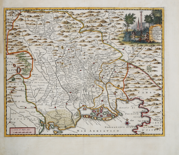
Map taken from "Thesaurus Antiquitatum et Historiarum Italiae, Neapolis, Siciliae Sardiniaae, Corsicae and Melitae," a monumental work by Georgius Graevius published in the first quarter of the 18th century.
Between 1704 and 1725, the 45 volumes of the "Thesaurus antiquitatum" were printed in Leiden, a complex, laborious generation, extolled by some as extraordinary, criticized, on the other hand, by others, who spoke of it as a "compilation énorme sans choix e sans ordre". A project that concerned contemporaries a great deal, in Italy, but interested little historiography afterwards, which, except in rare cases, emphasized its merely scholarly character and substantial uselessness.
However, Graevius' work is enriched by the valuable plates signed by Dutch publisher Pieter Vander AA.
Pieter van der Aa was by 1682 the owner of a bookstore and auction house. During his lifetime he published an enormous amount of printed material. After 1700, van der Aa specialized more and more in geography and travel books. He published composite atlases, a series of geographical descriptions of European countries, and some very spectacular works. Between 1706 and 1708 he published Naauweurige versameling der gedenkwaardigste zee- en land-reysen, in 28 volumes. Many of Van der Aa's publications are richly illustrated with maps and plates. He took over many copperplates and prints from other publishers such as Carel Allard and Frederik De Wit. The composite atlases that came out of his workshop contain a curious mixture of his own material, copies of maps from other publishers, and reprints of old copper plates, now bearing his signature.
The Galérie agréable du monde, completed in 1729, comprised 66 parts, bound in 27 volumes. Van der Aa presented it as a good investment; after publication, the work's antiquarian value would double, especially since it was printed in a limited edition of only one hundred examples.
“Un rifacimento maginiano, già segnalato dal Valentinelli nella sua Bibliografia del Friuli al n. 10 e dal Saggio marinelliano al n. 1054, è la nitidissima stampa che qui riproduciamo per prima, di proprietà dell'Istituto di Geografia della Facoltà di Magistero di Trieste, la quale porta il nome di Pieter Van der Aa. Nell'angolo in alto, a destra, su una lapide si legge: "FORO (sic) IULIENSIS PROVINCIAE / Accuratissima / Geographica Tabula / Novissime Delineata./LUGD [onum] BAT[avorum] Impensis / PETRI VANDER AA.". Essa si trova unita all'opera di Palladio Enrico le oppugnatione gradiscana in Graevii thesaurus antiq.et histor. Ital. pubblicato nel 1722, e precisamente nella quarta parte del tomo VIo nella monumentale raccolta dello stesso Van der Aa intitolata La Galerie agréable du Monde les estampes avant ete dessinées sur les lieux et gravée exхасtement par les celébres Luyken, Mulder, Goerée, Baptist, Stapendaal, et par d'autres maitres renomez... le tant mis en ordre et executé a Leide, par P. Vander Aa. Quest'opera, edita a Leida nel 1729, è abbastanza rara: sembra, infatti, che di essa siano stati tirati solo un limitato numero di esemplari). Per dare l'idea della mole di questo lavoro, aggiungiamo soltanto che è costituita da 66 tomi compresi in 20 o 27 volumi a seconda della legatura e che contiene oltre 3000 tavole. La carta misura mm 293x365. Ha un margine graduato di 1' in 1'. L'orientazione, che risulta indicata da una piccola rosa dei venti posta nel Golfo di Trieste, è quella consueta. La scala è di Miglia dieci (= mm 40). Riproduce integralmente e con molta cura, tutti i toponimi e la loro grafia, quali erano apparsi nel disegno maginiano della Patria del Frivli olim Forum Ivlii, testimoniando la vitalità, che questo modello manteneva, a distanza di un secolo e nono- stante la disponibilità di documenti migliori. Rispetto a questa carta rivela soltanto alcune piccole differenze formali, consistenti in un diradamento del rilievo, nella insignificante variazione di qualche forma della nomenclatura, (come Cra M. invece di quella di cra M., per i monti Ocra, Pu[n]ta distrugnan per Punta Distrugnan), есс..“ (Lago, Rossit "Theatrum Fori Iulii" vol. 2, p.138)
Etching, finely hand-colored, in excellent condition.
Bibliografia:
Lago, Rossit "Theatrum Fori Iulii" vol. 2, p. 138, Tav. CXLI; Koeman pagg. 22/23; Cremonini pag. 78.
Pieter VANDER AA (1659 - 1733)
|
Records show that van der Aa, born in Leyden in 1659, made an early start in life by being apprenticed to a bookseller at the age of nine and starting on his own in business as a book publisher by the time he was twenty-three.
During the following fifty years he published an enormous amount of material, including atlases and illustrated works in every shape and size, two of them consisting of no less than 27 and 28 volumes containing over 3,000 maps and plates.
Most of his maps were not of the first quality and were certainly not original, but they are often very decorative and are collected on that account.
|