

| Reference: | S27031 |
| Author | Jodocus HONDIUS |
| Year: | 1598 ca. |
| Zone: | Friuli |
| Printed: | Amsterdam |
| Measures: | 120 x 85 mm |


| Reference: | S27031 |
| Author | Jodocus HONDIUS |
| Year: | 1598 ca. |
| Zone: | Friuli |
| Printed: | Amsterdam |
| Measures: | 120 x 85 mm |
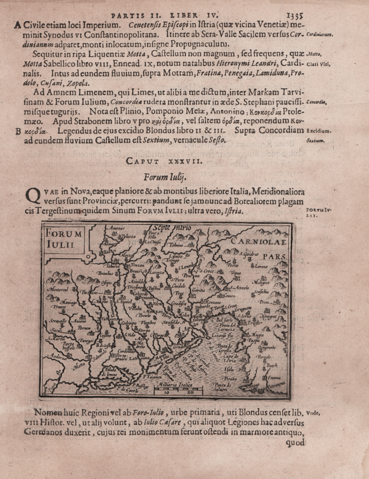
Taken from the first edition of "Cosmographia Universalis" by Paul Merula, printed in Amsterdam in 1605.
The map was first issued in 1598 by Cornelis Claesz and engraved and realized by Jodocus Hondius and Pietre vand den Keere (Kaerius).
Claesz used the plate to illustrate various works he published by Peter Apian, Jan van Linschoten, Paul Merula and others.
“A conferma della fortuna incontrata da questa carta dell'Ortelio, riproduciamo anche la cartina, che ne è un evidente rifacimento, sia pure con diversa scala e diversa inquadratura, pubblicata alla pagina 1335 di una delle edizioni della "Cosmografia Gene- rale" di Paul van Merle o Paulus Merula. Essa si intitola: "Paulli G.F.P.N. Merulae / COSMOGRAPHIAE / GENERALIS / LIBRI TRES: /Item/ GEOGRAPHIAE PARTICVLARIS / LIBRI QVA- TVOR: /Quibus EVROPA in genere; speciatim HI- SPANIA, /GALLIA, ITALIA, describuntur./ Cum tabulis Geographicis aeneis./ Ex officina Plantiniana / Raphelengij./M.D.CV./Veneunt etiam Amstelda- mi apud Cornelivm Nicolai/" (Biblioteca Nazionale Marciana di Venezia, n. 225. C. 21). Essa reca, in alto, a sinistra, il titolo “FORUM IULII". Manca la graduazione ai margini, mentre l'orientazione è quel- la consueta. In basso, sopra il rigo marginale interno le parole Milliaria Italica accompagnano l'indicazio- ne della scala grafica di 20 miglia (= mm 24).
Una sua reincisione, con lievi divergenze formali (l'aggiunta di un margine graduato di 4' in 4', lo spostamento di qualche toponimo, come quello di La Chiusa che indica Chiusaforte, la grafia su una riga invece che su due, come per Portogruaro, apparirà in edizioni più tarde […]. Rispetto al documento orteliano manca, ad ovest, la raffigurazione del corso medio e superiore del Piave, a nord, il tratto alpino a monte di Pontebba mentre, ad est, l'Istria non è disegnata per intero. Lo scheletro cartografico nei tratti essenziali, cioè, per quanto riguarda l'andamento delle coste e della rete fluviale, è identico. Nell'orografia e nella rappresentazione dell'insediamento umano si nota, invece, un più generale sfoltimento, che, pur giustificato dalla minor scala, si rivela, tuttavia, assai poco razionale, in quanto privilegia sedi anche insignificanti rispetto a quelle decisamente importanti, come Gemona, Spilimbergo, ecc. Anche qui, come nell'Ortelio, si cerca invano Palmanova, la cui costruzione, nel frattempo, era stata completata. Si notano, inoltre, le stesse forme toponomastiche come B. de Sesto, per l'Abbazia di Sesto al Reghena e le stesse storpiature, come Pornon per Pordenone, ma se ne aggiungono anche altre, come Moi/falcon/e per Mont./falcone, Paspa per Raspa (Raspo, nell'Istria).” (Lago, Rossit "Theatrum Fori Iulii" vol. 1, p.149)
Copperplate, inset in a page text, very good conditions.
Bibliografia:
Lago, Rossit "Theatrum Fori Iulii" vol. 1, pp. 149-150, Tav. LVII; King pp.80/81.
Jodocus HONDIUS (Amsterdam 1563 - 1612)
|
Jodocus Hondius (1563-1612) was a foremost map engraver of his day; he worked for many Dutch publishers, and was employed by the English map and print-sellers, Sudbury and Humble, to engrave the maps for John Speed’s The Theatre of The Empire of Great Britaine, published in 1612. In 1604, Hondius bought the copperplates of Mercator’s Atlas at the auction of Gerard Jr.’s effects. He added another forty maps, including new maps of the Continents and important regional maps of the Americas, before publishing a new edition of the Atlas, in 1606, in competition with Ortelius’ Theatrum. As many of the maps were more up-to-date, the Mercator-Hondius Atlas effectively superseded Ortelius’ Theatrum. On his death in 1612 his widow, Coletta van den Keere continued the business; from 1619 onwards their son Henry (II) (1597-1651) took over. From 1633 publication was carried on in co-operation with Jan Jansson Jr., Henry’s brother-in-law.
|