

| Reference: | S46917 |
| Author | Johannes Baptiste VRIENTS |
| Year: | 1606 ca. |
| Zone: | British Isles |
| Printed: | Antwerpen |
| Measures: | 580 x 440 mm |


| Reference: | S46917 |
| Author | Johannes Baptiste VRIENTS |
| Year: | 1606 ca. |
| Zone: | British Isles |
| Printed: | Antwerpen |
| Measures: | 580 x 440 mm |
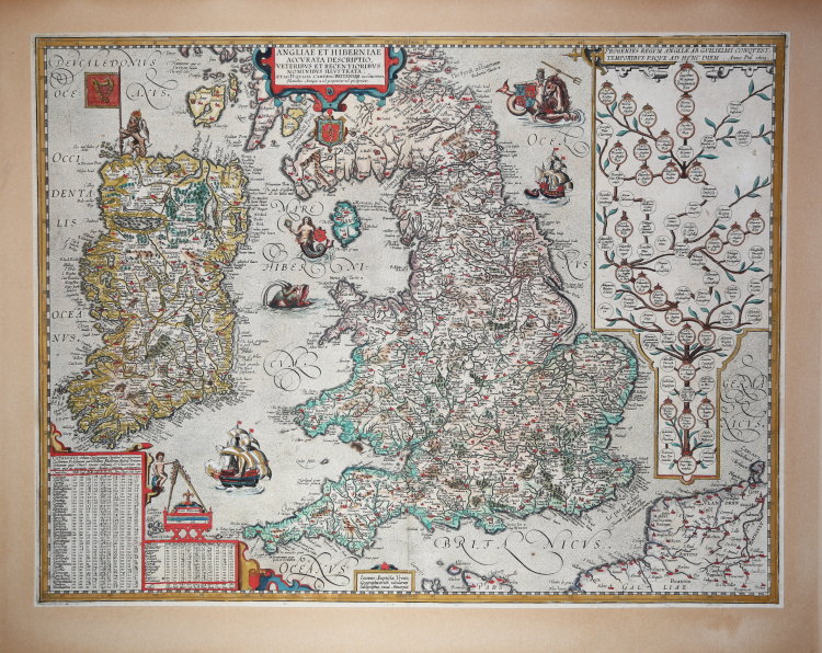
A rare early map of England and Ireland (and part of Scotland). Full title in a small cartouche middle top: ‘ANGLIAE ET HIBERNIAE | ACCVRATA DESCRIPTIO, | VETERIBVS ET RECENTIORIBVS | NOMINIBVS ILLVSTRATA: | ET AD D. GVLIEL. CAMDENI BRITANIAM ACCOMODATA’
Fine example of Vrients’ map of Britain and Ireland, which first appeared in the 1606 edition of Ortelius' Theatrum Orbis Terrarum, the first modern atlas of the world.
The Vrients map is one of the most distinctive maps of the British Isles ever to appear. The map includes a genealogical plate of the English royal family on the right side, tracing the lineage of James I and VI directly from William the Conqueror, who successfully invaded England in 1066. Other details document of noble connections. A Poseidon-like figure, riding a hippocampus, holds the arms of the House of York. A mermaid carries the arms of the Isle of Man, while the coat of arms of Scotland is installed near the Firth of Clyde (here Dunbreton Fyrth). A crowned lion holds the Irish flag with its harp, a reference to the English colonization of the island. The map includes modern and ancient names for towns and sites on the islands. At the lower left is an ingenious table listing the number of towns, churches, parishes, rivers, bridges and other features of each county.
Example of the second state, with the removal of the controversial description of James I as King of France. Van den Broecke mentions that there are 3 states on the map: the first bears the name of James I as King of France at the top. A variant of the first state, sees the error corrected by an applied leaflet that reads "Unum qua ad Dominum Britannia tota redisti, Una tibi ô redeat sic quoque prisca fides". The second state now reads "1603 Iacobus Magnæ Britanniæ Rex”.
This map was engraved in 1606, by or for Jan Baptista Vrients, for inclusion in Ortelius' Theatrum, which Vrients continued to publish as Ortelius' executor. Therefore, it appeared only in the final four editions of Ortelius' atlas and is consequently one of the scarcest maps among those appearing in that work. It constitutes the pinnacle of decorative cartography and ranks among the most lavishly engraved maps.
Johannes Baptista Vrients (1552-1612) was a Flemish engraver, publisher and cartographer. Not much is known about his early life, but it is assumed that he grew up as an apprentice among the cartographers of Antwerp, where the guild appointed him master in 1575. In the 1590s he executed maps of the world for Plancius and Linschoten. In 1600 he became executor of Ortelius' will and acquired the plates of the Theatrum after the cartographer's death. Between 1606 and 1612 he published more editions of Ortelius' atlas. Vrients also acquired De Jode's Speculum plates around 1600. Vrients' editions of the Theatrum were published not in Antwerp (the city had fallen during the Dutch war with Spain) but in Amsterdam.
Etching with contemporary coloring, trimmed to the platemark and laid down on antique mounting, very good condition.
As this map only appears in the later editions of the Theatrum it is comparatively rare: Van den Broecke estimates that only about 1,250 were printed. Shirley notes that because the map is larger than the standard Ortelius maps it is 'often found with damage to the margins'.
Bibliografia
M. van den Broecke, M. Ortelius Atlas Maps: An illustrated Guide n. 17 II; R.W. Shirley (1991) Early Printed Maps of the British Isles 1477-1650, , p. 112-113; A. Kelly “Maps of the British Isles, England and Wales, and Ireland”, p. 221-238, in Van den Broecke, van der Krogt & Meurer “Abraham Ortelius and the First Atlas”.
Johannes Baptiste VRIENTS (1552 - 1612)
|
Vrients was the map engraver and publisher in Antwerp who, after the death of Ortelius in 1598, acquired the publication rights of the Theatrum. Between 1601 and 1612 he issued a number of editions which included some of his own maps and he was responsible for printing the maps for the English edition in 1606. He also published a number of important individual maps and a small atlas of the Netherlands.
|