

| Reference: | S46310 |
| Author | Joseph ROUX |
| Year: | 1779 |
| Zone: | Corfu |
| Printed: | Genua |
| Measures: | 210 x 140 mm |


| Reference: | S46310 |
| Author | Joseph ROUX |
| Year: | 1779 |
| Zone: | Corfu |
| Printed: | Genua |
| Measures: | 210 x 140 mm |
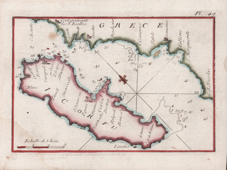
Carta nautica delll'isola di Corfù tratta dal celebre Recueil des principaux plans des ports et rades de la mer méditerranée estraits de ma carte en douze feuilles, dédiée à Monseigneur le Duc de Choiseul ministre de la guerre et de la marine. Par son très humble serviteur Joseph Roux, hydrographe du roy.
A Genes chez Yves Gravier Libraire sous la Loge de Banchi. 1779.
Seconda edizione, accresciuta, di questa celebre raccolta di piani nautici del Mediterraneo, completa di 123 incisioni in rame che mostrano le piante dei principali porti o rade del Mediterraneo, con scandagli, possibili ancoraggi, la natura dei fondali, così come le città, fortificazioni, cittadelle, arsenali e fari ad essi collegati. Ogni mappa ha una scala in leghe, toises o miglia di Provenza. Questa importante raccolta, la più completa e precisa per la sua epoca, è dovuta a Joseph Roux.
I Roux di Marsiglia erano una famiglia di idrografi e pittori specializzati in ritratti di uomini di mare e navi. Joseph Roux nacque nel 1725, da Joseph Roux l'Ancien (1682-1742), che lavorava come idrografo, e Magdaleine Senequier. Fu suo padre che aprì un negozio idrografico nel porto di Marsiglia nel 1708, sotto l’insegna La Boussole Couronnée. Joseph Roux le Jeune, è conosciuto come l'inventore del genere del ritratto di nave, un genere che fu perfezionato dalle tre generazioni successive. Si dedicò subito all’attività di famiglia, diventando idrografo come suo padre, producendo, pubblicando e vendendo un vasto assortimento di carte nautiche e strumenti di navigazione. Intorno alla metà del secolo, ricevette l’onorificenza di Hidrographe du Roy e, nel 1764, pubblicò una serie di 12 carte del Mediterraneo, un atlante nautico che venne usato per un certo numero di anni, persino sulle navi inglesi. Contemporaneamente, pubblicò la prima edizione – che comprendeva 65 tavole di formato tascabile – del Recueil des principaux plans des ports et rades de la mer méditerranée (Marsiglia 1764), successivamente ristampato - ampliato - a Genova da Yves Gravier nel 1779 e infine, con il titolo Recueil de 163 principaux plans des ports et rades de la Mediterranée, nel 1804. Per tutto il XIX secolo, seguirono svariate edizioni, alcune ampliate, sia in Francia sia in Italia. Alcune a cura dello stesso Roux, mentre altre erano copie non autorizzate.
Acquaforte, in ottimo stato di conservazione.
Bibliografia
National Maritime Museum, III, n. 269; cfr. P. C. F. Smith, The Artful Roux: Marine Painters of Marseille, Peabody Museum of Salem, 1978; Nordenskiöld 254.
Joseph ROUX (Attivo nella seconda metà del XVIII sec.)
|
Joseph Roux was a Marseilles hydrographer who both published and as well manufactured and sold charts, navigating instruments and related nautical equipment.
At about the mid-century, he received the right to be called "Hidrographe du Roy," and in 1764 published a series of 12 charts of the Mediterranean; he simultaneously published this smaller format atlas of 65 harbor charts. Several editions followed until well into the 19th century, both in France and in Italy, all enlarged. Some were by Roux himself, some were pirated.
Sanderson, The Sea Chart, p. 91, calls this "a popular book," but few examples survive, and all editions are rare
|