

| Reference: | S47180 |
| Author | Henri Abraham CHATELAIN |
| Year: | 1708 ca. |
| Zone: | The Roman Empire |
| Printed: | Amsterdam |
| Measures: | 445 x 340 mm |


| Reference: | S47180 |
| Author | Henri Abraham CHATELAIN |
| Year: | 1708 ca. |
| Zone: | The Roman Empire |
| Printed: | Amsterdam |
| Measures: | 445 x 340 mm |
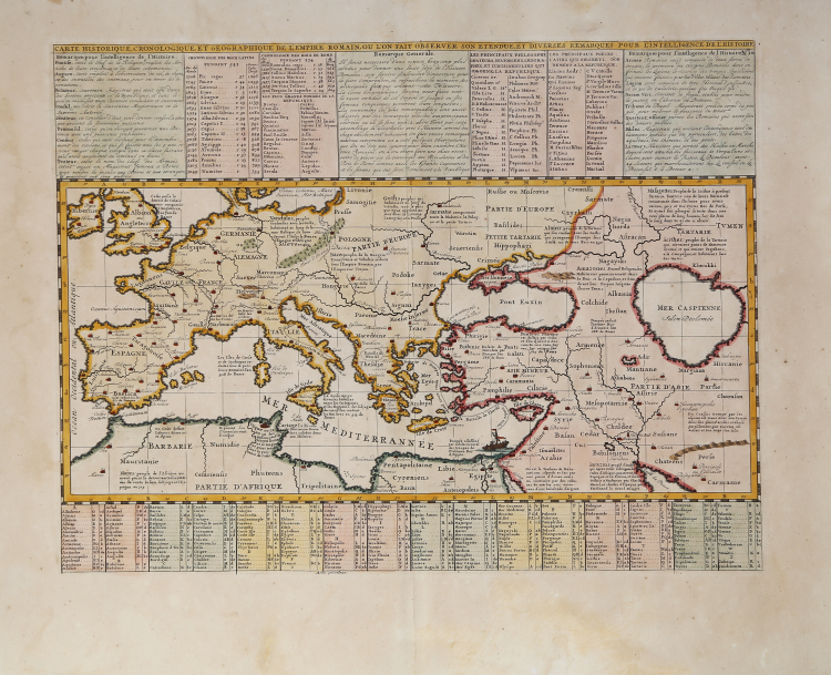
Carte Historique, Cronologique, et Geographique de l'Empire Romain, ou l'on Fait Observer son Etendue, et Diverses Remarques pour l'Intelligence de l'Histoire
Fine map showing the full extent of the Roman Empire in Europe, Asia and northern Africa. The map is keyed to tables providing information on Roman administrators, emperors, historians, poets, etc. Size includes text panels.
This interesting historical map by Chatelain depicts the regions of the Mediterranean, Black and Caspian Sea which were under Roman Rule. Chatelain provides in-depth detail including extensive notes , trade routes, names of the different kingdoms, fiefdoms, etc. Major cities and important fortifications are noted. A decorative element is in the eastern Mediterranean in the form of a frigate and a smaller vessel nearby. Ancient civilizations are also named and historical notes are provided regarding the majority of them.
Henri Abraham Chatelain (1684-1743) was a Huguenot pastor of Parisian origins. Chatelain proved a successful businessman, creating lucrative networks in London, The Hague, and then Amsterdam. He is most well known for the Atlas Historique, published in seven volumes between 1705 and 1720. This encyclopedic work was devoted to the history and genealogy of the continents, discussing such topics as geography, cosmography, topography, heraldry, and ethnography. Published thanks to a partnership between Henri, his father, Zacharie, and his younger brother, also Zacharie, the text was contributed to by Nicolas Gueudeville, a French geographer. The maps were by Henri, largely after the work of Guillaume Delisle, and they offered the general reader a window into the emerging world of the eighteenth century.
Henri Abraham CHATELAIN (1684 - 1743)
|
Henri Abraham Chatelain (1684 - 1743) was a Huguenot pastor of Parisian origins. He is best known as a Dutch cartographer and more specifically for his cartographic contribution in the seminal seven volume Atlas Historique, published in Amsterdam between 1705 and 1720. Innovative for its time, the Atlas Historique combined fine engraving and artwork with scholarly studies of geography, history, ethnology, heraldry, and cosmography. Some scholarship suggests that the Atlas Historique was not exclusively compiled by Henri Chatelain, as is commonly believed, but rather was a family enterprise involving Henri, his father Zacharie and his brother, also Zacharie. The Atlas Historique published by Chatelain was part of a major work of its time, an encyclopaedia in seven volumes including geography as one of its main subjectes. The text was by Nicholas Gueudeville and the maps by Chatelain. The Atlas included one of the finest maps of America (4 sheets) surrounded by vignettes and decorative insets.
1705-20 Atlas Historique:Amsterdam (maps by Chatelain based on G.Delisle)
Further issues to 1739
|