| Reference: | S46336 |
| Author | Cornelis II DANKERTS |
| Year: | 1710 |
| Zone: | Holy Land |
| Printed: | Amsterdam |
| Measures: | 526 x 360 mm |
| Reference: | S46336 |
| Author | Cornelis II DANKERTS |
| Year: | 1710 |
| Zone: | Holy Land |
| Printed: | Amsterdam |
| Measures: | 526 x 360 mm |
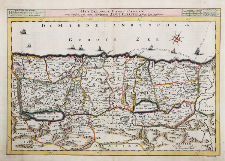
Antique map of the Holy Land titled 'Het Beloofde Landt Canaan.' This finely engraved and very detailed map of the Holy Land is embellished with sailing ships showing the route of St. Paul to Rome and a compass rose.First state with Danckerts' imprint; the second state shows the address by R. & J. Wetstein & William Smith (Amsterdam) and Samuel Luchtmans (Leiden).
Made by 'Albert Schut' after 'Cornelis Danckerts'. Cornelis Danckerts II (1603-1656) was a succesful Amsterdam-based art-. print- and map-seller. (He called himself 'Papiere, konst en caertverkoper.') His sons Dancker II and Justus were active in the business as well. The Danckerts were a well known family containing several engravers, cartographers and print-sellers that started with the founder Cornelis Danckerts I (1536-1595) who was the city carpenter.
Copperplate with fine later hand colour, good condition.
Bibliografia
Poortman, Kaarten in Bijbels, 32.
Cornelis II DANKERTS (Amsterdam 1664-1717)
|
The Danckerts were a family of Dutch engravers and geographers who produced geographical material, including a series of original atlases. Initially, Justus I Danckerts (1635-1701) was a book and print publisher based in Amsterdam. His great uncle, Cornelis Danckerts de Rij (1561-1634), was a topographer who produced a Kaert-boeck with various views of Amsterdam. His brother, Dancker Danckerts (1634-1666), was a skilled engraver who produced several maps. Most likely Justus I was influenced by the work of both when he followed his father, Cornelis I Danckerts (1603-1656), into the publishing business. In the early 1680s, Justus decided to undertake a new project, an atlas with all the maps made at home. This project was feasible because two of his sons with his wife, Elisabeth Vorsterman, Theodore I (c. 1663-c. 1720) and Cornelis II (1664-1717), had recently come of age and had training in engraving and etching. Justus' decision was probably influenced by his surroundings; Amsterdam was the center of cartographic publishing in the 17th century, and in the 1680s several local publishers sought to enter the atlas market, then dominated by Blaeu and Hondius-Janssonius atlases. Together, the brothers created their first maps in the mid-1680s. In 1684, the family was granted a 15-year privilege to protect their maps and published both in-folio maps, the basis of an atlas, and wall maps for sale. Their early atlases contained about 20 original maps and 4-5 maps by other cartographers such as Visscher and De Wit. The earliest atlas known to contain only Danckerts' maps is a 26-sheet volume published in 1690. As an example, the Danckerts turned to similar atlases by De Wit, but by 1690 they clearly had the knowledge and ability to produce their own original work. Although it was not as long-lived as other family businesses, for the decades at the turn of the seventeenth century the Danckerts family produced highly regarded and widely distributed wall maps and atlases. Their entry into the atlas trade came at a time of growing popularity, and the expansion in the number of sheets included in their atlases indicates both their popularity and the skill of the engraving brothers.
|