| Reference: | S46331 |
| Author | Daniel Stoopendaal |
| Year: | 1702 |
| Zone: | Jerusalem |
| Printed: | Amsterdam |
| Measures: | 460 x 360 mm |
| Reference: | S46331 |
| Author | Daniel Stoopendaal |
| Year: | 1702 |
| Zone: | Jerusalem |
| Printed: | Amsterdam |
| Measures: | 460 x 360 mm |
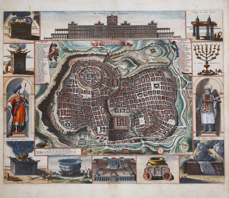
Magnificent, imaginary plan of Jerusalem from 1702, drawn and engraved by Daniel Stoopendaal but based on an early work by Juan Bautista Villalpando.
Published in the Biblia, dat is De gantsche H. Schrufture, published in Amsterdam by brothers Pieter and Jacob Keur, 1702.
Villalpando's popular vision of Jerusalem first appeared in a 1604 commentary on Ezekiel, written jointly by Villalpando and Hieronymus Prado. The west-facing plan is based on the Book of Ezekiel and the writings of the first-century Jewish historian Flavius Josephus, among other sources. The main elements are the Temple of Solomon, bottom center, the City of David, top left, and the historic city walls. The structure of Solomon's Temple, including the nine square courtyards, is based on Villalpand's interpretation of Ezekiel's prophecy of a Third Holy Temple. The entire map is surrounded by twelve vignettes relating to Solomon's Temple, including a view of the Temple itself, the Arch of the Covenant, an altar, a menorah, a statue of Solomon, the Tabernacle and an altar of sacrifices.
This map was published by the Keur family in its popular Bible, one of the Dutch "State Bibles" published between 1637 and 1760, which contained five or six maps.
Daniel Stoopendaal (1672-1726) was a Dutch engraver and cartographer active in Amsterdam in the early part of the 17th century. Stoopendaal is best known for his prints of gardens and landscapes. Cartographically, Stoopendaal's most important work are precisely these new interpretations of Cornelisz Jansz's maps. Visscher of the Holy Land for inclusion in the Keur Bible. Daniel Stoopendaal is often confused with Bastiaan Stoopendaal, an engraver associated with the Visscher firm, with whom he often worked but was most likely not related.
Etching, with magnificent hand coloring, in excellent condition.
Daniel Stoopendaal (1672-1726)
|
Daniel Stoopendaal (1672-1726) was a Dutch engraver and cartographer active in Amsterdam in the early part of the 17th century. Stoopendaal is best known for his prints of gardens and landscapes. Cartographically, Stoopendaal's most important work are precisely these new interpretations of Cornelisz Jansz's maps. Visscher of the Holy Land for inclusion in the Keur Bible. Daniel Stoopendaal is often confused with Bastiaan Stoopendaal, an engraver associated with the Visscher firm, with whom he often worked but was most likely not related.
|