

| Reference: | S48932 |
| Author | Jacobi TIRINI |
| Year: | 1632 ca. |
| Zone: | Holy Land |
| Measures: | 820 x 330 mm |


| Reference: | S48932 |
| Author | Jacobi TIRINI |
| Year: | 1632 ca. |
| Zone: | Holy Land |
| Measures: | 820 x 330 mm |
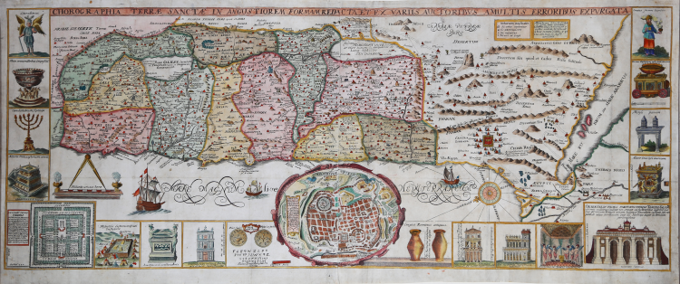
Extraordinary map of the Holy Land, circa 1632, by Jesuit monk Jacobi Tirini [Tirinus]. Oriented east, the map depicts from Syria and Tyre southward to Sinai, Egypt and Thebes.
Cartographically it is derived from that of Christian van Adrichom, printed in Amsterdam in 1590. In the lower center, within a vaulted cartouche, is a planimetric depiction of the city of Jerusalem based on the famous model by Juan Batista Villalpando (Rome, 1604). Surrounding the actual map, on the left, right and lower margins, are 18 other maps and images of biblical objects, which include the Ark of the Covenant, Israelite coins, Roman antiquities, views of a Menorah, various angels and a plan of the Temple in Jerusalem.
Originally prepared in 1632 for the study of Jacobus Tirinus Holy Land Commentarius Vestus et Novum Testamentum Tomis Tribus Comprehensus, it was probably engraved by Cornelius Galle and printed in Antwerp by Martinus Nutius. Due to its great success, the map was printed several times in the 20 years following the original edition, so determining the exact edition is quite impossible.
“The chorography of the Holy Land with correction of the many errors made by various authors. Oriented to the east. Shows the distribution of the Tribes on both sides of the Jordan, the shore line running from "Sidon" as far as the Nile Delta. "Cishon" connects Haifa Bay with the Lake of Tiberias. At bottom center, an inset oval map of ancient Jerusalem: "Hierosolymae veteris imago." 123 × 160 mm Along both sides and the bottom, 16 vignettes of biblical objects. In the left bottom corner, a plan of the Temple and in the right bottom corner, a view of the Temple. Printed on two sheets joined together. From: Tirinus, Jacobus, Commentarius in Vetus et Novum Testamentum, Antwerp, Martinus Nutius, 1632. Vol. I, inserted in the beginning. Probably engraved by Cornelis Galle. Evidently a copy of Adrichom's map, despite the author's claims in title. The inset of Jerusalem is drawn after Villalpando” (cfr. Eran Laor, Maps of the Holy Land, Printed Maps 1475-1900, p. 106, n. 771).
Jacobi Tirini (1580 - 1636), who signed his work Jacobus Tirinus, was a Jesuit monk, theologian, historian and biblical scholar. His main work was Commentarius in Sacram Scripturam, a biblical dissertation in two volumes. Tirini was born in Antwerp, Belgium, in 1580. After admission to the Jesuit Order, he became an esteemed biblical scholar and a leading member of the Order. He was appointed “First Superior” of the Jesuit House in Antwerp and “Director of the Mission of Holland.” Tirini's Bible commentaries are still referenced today.
Overall this is an extraordinary work, one of the most decorative maps of the Holy Land ever made.
Etching, printed from two copper plates on as many sheets of contemporary laid paper, finely hand-colored, in excellent condition.
Bibliografia
Eran Laor, Maps of the Holy Land, Printed Maps 1475-1900, p. 106, n. 771.
|
Jacobus Tirinus (1580–1636) was a Belgian Jesuit Biblical scholar. His major work is the Commentarius in Sacram Scripturam, a Bible commentary in two volumes from 1645. He also published a chorography, Chorographia Terrae Sanctae in Angustiorem Formam Redacta, around 1630.
|
|
Jacobus Tirinus (1580–1636) was a Belgian Jesuit Biblical scholar. His major work is the Commentarius in Sacram Scripturam, a Bible commentary in two volumes from 1645. He also published a chorography, Chorographia Terrae Sanctae in Angustiorem Formam Redacta, around 1630.
|