
| Reference: | S48927 |
| Author | Adolphe Hippolite DUFOUR |
| Year: | 1846 |
| Zone: | Holy Land |
| Printed: | Paris |
| Measures: | 255 x 335 mm |
| Reference: | S48927 |
| Author | Adolphe Hippolite DUFOUR |
| Year: | 1846 |
| Zone: | Holy Land |
| Printed: | Paris |
| Measures: | 255 x 335 mm |
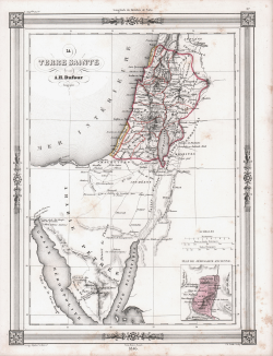
Map prepared by Auguste Henri Dufour for publication in Maison Basset's 1848 edition of Atlas Illustre Destine a l'enseignement de la Geographie elementaire.
Maison Basset (1819 - 1865) was a French publishing concern active through the mid to late 19th century. The firm can trace their roots to André Basset (or Bassett) (fl. 1768 - 1784), who starting publishing maps, prints, and books around 1768. Maison Basset, also Chez Basset, is the imprint under which the heirs of Paul-André Basset (1785 - 1819) published the works of such prominent French cartographers and engravers as Barbie du Bocage, A. Vuillemin, J. B. Charle, V. Levasseur, Tu. Duvotenay, H. Dufor, F. E. George, and others. Their library of publications is diverse and vast, but heavily focused on medical and scientific texts, including several important atlases.
Adolphe Hippolyte Dufour (1798 - 1865), also known as Auguste-Henri Dufour, was a Paris based map and atlas publisher active in the mid to late 19th century. Dufour claimed to be a student of another French cartographer, Emile Lapie. His is known to have worked with numerous other cartographers, publishers and engravers of the period including Dyonnet and Duvotenay. His corpus includes numerous maps and atlases, the most striking of which is probably his monumental 1857 elephant folio Grand atlas Universel physique, historique et politique geographie ancienne et moderne.
Copper engraving with original outline colour, some foxing, otherwise good condition.
Adolphe Hippolite DUFOUR (Parigi 1798 - 1865)
|
Adolphe Hippolyte Dufour (1798 - 1865), also known as Auguste-Henri Dufour, was a Paris based map and atlas publisher active in the mid to late 19th century. Dufour claimed to be a student of another French cartographer, Emile Lapie. His is known to have worked with numerous other cartographers, publishers and engravers of the period including Dyonnet and Duvotenay. In 1824, he first published a geographical analysis of the map of Palestine under his own name, and from then on took part in a series of historical and topographical publications for which he prepared and drew plans and maps. His corpus includes numerous maps and atlases, the most striking of which is probably his monumental 1857 elephant folio Grand atlas Universel physique, historique et politique geographie ancienne et moderne. His main works are: L'atlas élémentaire et universel de géographie ancienne et moderne (1828); Plusieurs Précis de système planétaire et de cosmographie; L'atlas joint à la France illustrée de Victor Adolphe Malte-Brun (1855); L'atlas Dufour, atlas universel, physique, historique et politique de la France, de ses départements et de ses colonies (1857).
|