

| Reference: | S11293 |
| Author | Heinrich BUNTING |
| Year: | 1581 ca. |
| Zone: | The Holy Land |
| Printed: | Magdeburg |
| Measures: | 360 x 260 mm |


| Reference: | S11293 |
| Author | Heinrich BUNTING |
| Year: | 1581 ca. |
| Zone: | The Holy Land |
| Printed: | Magdeburg |
| Measures: | 360 x 260 mm |
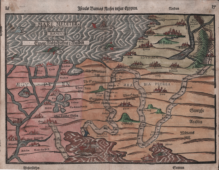
Map of the Holy Land from Bunting's "Itinerarium Sacrae Scriptura".
Shown the way of the people of Israel from the Exodus from Egypt to the passage through the Red Sea, through the desert to the Promised Land. (2nd book of Moses, Exodus). The corresponding biblical passages are noted in the map.
This scarce map is from Heinrich Bunting's Itinerarum Sacrae Scripturae.. It is believed that more than 60 editions of Bunting's Itinerarum were published in various languages between 1581 and 1757. Bunting's work describes the travels of religious figures in the Bible and was the most complete summary of geography of the Bible of this period. Itinerarum Sacrae Scripturae was first printed in Helmstadt in 1581 and was produced in numerous editions in Germany. The book was so popular, it was also issued with text in Danish, Swedish, Dutch, Czech, and English.
Henrich Bunting was a Protestant theologian and teacher born in Hanover, in what is now Germany. He attended the University of Wittenberg and graduated in 1569. He then began work as a preacher but caused some controversy with his teachings; he was dismissed from appointments in both Lemgo and Goslar.
He is best known today for his book, Itinerarium Sacrae Scripturae (Travel book through Holy Scripture), a travel collection and commentary of the geography of the Bible. The book provided the most complete summary of biblical geography then available and described the Holy Land by following the travels of various notable people from the Old and New Testaments. First published in Madgeburg in 1581, Itinerarium Sacrae Scripturae was a very popular book for the time. Over 60 editions were published between 1581 and 1757.
A particularly notable feature of the book were its many woodcut maps, many of them showing unique depictions of geographic features and continents. In addition to the conventional maps, the book also contained three figurative maps; the world depicted using a cloverleaf design (thought to possibly represent the Trinity with Jerusalem in the center), Europe in the form of a crowned and robed woman, and Asia as the winged horse Pegasus.
Woodcut with fine later hand colour, German text on verso, in good condition.
|
Laor, E. Mapping of the Holy Land 142.
|
Heinrich BUNTING (1545 - 1606)
|
Heinrich Bünting was a protestant Theologian and Chronicler. His main work "Itinerarium sacrae scripturae" first published 1581, was much valued, mainly because of its emblematic maps, which show the world arranged in the form of a clover leaf with Jerusalem at the centre, Europe in the form of a Queen and Asia in the form of Pegasus.
|
|
Laor, E. Mapping of the Holy Land 142.
|
Heinrich BUNTING (1545 - 1606)
|
Heinrich Bünting was a protestant Theologian and Chronicler. His main work "Itinerarium sacrae scripturae" first published 1581, was much valued, mainly because of its emblematic maps, which show the world arranged in the form of a clover leaf with Jerusalem at the centre, Europe in the form of a Queen and Asia in the form of Pegasus.
|