

| Reference: | S30722 |
| Author | Gerard DE JODE |
| Year: | 1577 ca. |
| Zone: | Italy |
| Printed: | Antwerpen |
| Measures: | 520 x 370 mm |


| Reference: | S30722 |
| Author | Gerard DE JODE |
| Year: | 1577 ca. |
| Zone: | Italy |
| Printed: | Antwerpen |
| Measures: | 520 x 370 mm |
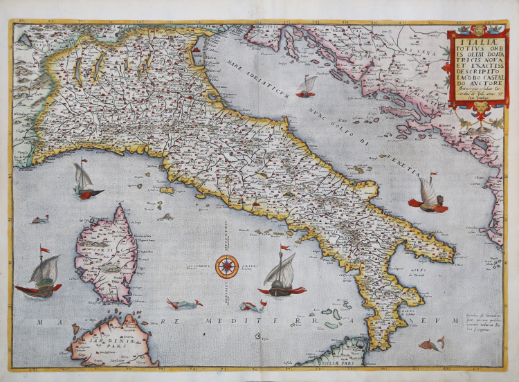
De Jode's map represents the first foreign reprint of Giacomo Gastaldi's mythical cartographic survey of the peninsula, published in Venice in 1561. Gastaldi's map was immediately an incredible success, and after 1567, the year of the Piedmontese cartographer's death, reprints, reductions, derivations and forgeries immediately began and continued until 1600.
Second edition of the map, with the indication of privilege in the cartouche.
Gerard de Jode, a publisher and cartographer with fervent activities in Antwerp, as early as 1568 produced a 4-sheet map of Gastaldi derivation; in 1578 the Flemish publisher published the first edition of his famous Speculum Orbis Terrarum, where he included a reduction of the map of Italy.
De Jode, after completing studies in mathematics and cosmography, learned the art of engraving, was for some time at the court of Charles V in Brussels, then moved to Antwerp, where as early as 1551 he began to print artistic engravings by Franz Huys, Martin de Vos, Corneille de Cort, etc. ; but soon specialized in engraving maps and printed in Antwerp the famous world map of Giacomo Gastaldi, in 1568 Italy by the same, then other maps by many authors, including Italians, in 1564 a large world map by Abraham Ortelius (Nova totius Terrarum Orbis iuxta neotericorum traditionem descriptio) and finally in 1578 a full-fledged atlas with the title Speculum Orbis Terrarum, in 65 plates, by different authors, already partly separately published. It is one of the earliest modern atlases (preceded only by Ortelius' Theatrum Orbis Terrarum), which is extremely rare today. In the last years of his life he waited to prepare large maps of the individual continents, which were perhaps later published, like a great world map, by his son Cornelius. The latter, born in Antwerp in 1568, continued his father's work with much sagacity; in 1589 he published a world map, in 1593 a new edition of the Speculum, enlarged, in 109 maps, and in 1596 an Introductio geographica in tabulas Europae, Asiae, Africae et Americae; the plates, alluded to here, are probably those prepared by his father and of which his son took care of the printing; they have not, however, come down to us. Cornelius then traveled extensively in the Nordic countries and also in Spain. Returning to his homeland, he died in Mons on October 17, 1600.
Etching and engraved by brothers Johannes and Lucas van Doetecum, finely hand-colored, in excellent condition.
Bibliografia
Van der Krogt 3 - 7000:32.2; Karrow - 30/90.6; R. Borri "L'Italia nelle antiche carte…" (2011), scheda 54; Perini pp. 30-32; Almagià p. 27.
|
Gerard de Jode, born in Nijmegen, was a cartographer, engraver, printer and publisher in Antwerp, issuing maps from 1555 more or less in the same period as Ortelius. He was never able to offer very serious competition to his more businesslike rival although, ironically, he published Ortelius's famous 8-sheet World Map in 1564.
His major atlas, now extremely rare, could not be published until 1578, eight years after the Theatrum, Ortelius having obtained a monopoly for that period. The enlarged re-issue by his son in 1593 is more frequently found. On the death of Cornelis, the copper plates passed to J. B. Vrients (who bought the Ortelius plates about the same time) and apparently no further issue of the atlas was published: however, at least one further issue of the Polar Map, c.1618, is known.
Son of Gerard de Jode, who was a cartographer, engraver, printer and publisher in Antwerp, issuing maps from 1555 more or less in the same period as Ortelius.
Gerard de Jode's major atlas, now extremely rare, could not be published until 1578, eight years after the Theatrum, Ortelius having obtained a monopoly for that period. The enlarged re-issue by his Cornelis in 1593 is more frequently found.
On the death of Cornelis, the copper plates passed to J. B. Vrients (who bought the Ortelius plates about the same time) and apparently no further issue of the atlas was published: however, at least one further issue of the Polar Map, c.1618, is known.
|
|
Gerard de Jode, born in Nijmegen, was a cartographer, engraver, printer and publisher in Antwerp, issuing maps from 1555 more or less in the same period as Ortelius. He was never able to offer very serious competition to his more businesslike rival although, ironically, he published Ortelius's famous 8-sheet World Map in 1564.
His major atlas, now extremely rare, could not be published until 1578, eight years after the Theatrum, Ortelius having obtained a monopoly for that period. The enlarged re-issue by his son in 1593 is more frequently found. On the death of Cornelis, the copper plates passed to J. B. Vrients (who bought the Ortelius plates about the same time) and apparently no further issue of the atlas was published: however, at least one further issue of the Polar Map, c.1618, is known.
Son of Gerard de Jode, who was a cartographer, engraver, printer and publisher in Antwerp, issuing maps from 1555 more or less in the same period as Ortelius.
Gerard de Jode's major atlas, now extremely rare, could not be published until 1578, eight years after the Theatrum, Ortelius having obtained a monopoly for that period. The enlarged re-issue by his Cornelis in 1593 is more frequently found.
On the death of Cornelis, the copper plates passed to J. B. Vrients (who bought the Ortelius plates about the same time) and apparently no further issue of the atlas was published: however, at least one further issue of the Polar Map, c.1618, is known.
|