
| Reference: | S50386 |
| Author | Gilles Robert de VAUGONDY |
| Year: | 1750 |
| Zone: | Italy |
| Printed: | Paris |
| Measures: | 165 x 165 mm |
| Reference: | S50386 |
| Author | Gilles Robert de VAUGONDY |
| Year: | 1750 |
| Zone: | Italy |
| Printed: | Paris |
| Measures: | 165 x 165 mm |
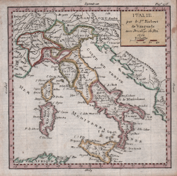
Piccola carta geografica dell’Italia di Robert de Vaugondy, tratta da Méthode Abrégée et Facile Pour Apprendre La Géographie, où l'on décrit la forme du Gouvernement de chaque Pays, ses qualités, les moeurs de ses Habitans, & ce qu'il y a de plus remarquable. Avec un Abrégé de la Sphère et une Table des Longitudes et Latitudes des principales Villes du Monde, conforme aux dernières Observations des Meilleurs de l'Académie des Sciences, et autre astronomes, stampato a Parigi intorno al 1750.
Acquaforte, finemente colorata a mano, in ottimo stato di conservazone.
Gilles Robert de VAUGONDY (1688 - 1766)
|
Didier Robert de Vaugondy (1723-1786) was appointed Geographer to Louis XV in 1760. At the same time, de Vaugondy served as Geographer to the Duke of Lorraine and Bar, father-in-law to Louis XV and former King of Poland.
His major contributions to French cartography are the Atlas Universel, 1750-57, The Nouvelle Atlas Portatif (1784) and a very popular map of North America published in 1761. He was son of Gilles Robert de Vaugondy who succeeded Pierre Sanson as the King's Geographer.
|