| Reference: | S46072 |
| Author | Abraham ORTELIUS |
| Year: | 1595 ca. |
| Zone: | Japan & Korea |
| Printed: | Antwerpen |
| Measures: | 485 x 360 mm |
| Reference: | S46072 |
| Author | Abraham ORTELIUS |
| Year: | 1595 ca. |
| Zone: | Japan & Korea |
| Printed: | Antwerpen |
| Measures: | 485 x 360 mm |
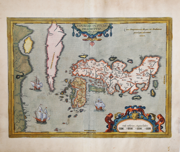
Nice original colour example of Ortelius' landmark map of Japan, the first map of Japan published in a European atlas. The map first appeared in the 1595 Additamentum Quintum, followed by the Latin edition of Ortelius's Theatrum Orbis Terrarum, the first modern atlas, on the same year.
Ortelius incorporated information derived from Ludovico Teixeira, a Portuguese Jesuit cartographer and mathematician. Teixeira utilized information generated from Japanese sources to present the first reasonably accurate and recognizable depiction of Japan, including numerous Japanese place names. Korea appears as an island, with its curious northern point named Punta dos Ladrones.
The map is richly embellished with three large galleons, two elaborate cartouches and a boldly engraved border. This influential map was to become the basis for many other cartographer's maps of Japan for more than fifty years.
A fine example of the first state, showing the date 1595. The second state of the map is known to have appeared only in Theatro D'El Orbe De La Tierra... M.DC.XII. [1641] with the letterpress title Iaponia Isla and the page number 120 (Van der Krogt 31:454).
“Before the publication of this map, the only two others based on geographic knowledge - the Cysat and the Piccaglia/Monte - were significantly inaccurate and not widely disseminated. Ortelius changed that in 1595 with the inclusion of this map in the Additamentum Quintum, followed by the Latin edition of the Theatrum in the same year. The map continued to be included in the Theatrum, unchanged, until at least the Spanish edition of 1612.
What little we know about the origins of this map and its alleged maker, Luís Teixeira, is included in the massive work by Armando Cortesão, the Portugaliae Monumenta Cartographica. In Volume III, p. 43, Cortesão quotes from a letter written by Teixeira to Ortelius advising him that he is forwarding "...two pieces of the descriptions of China and Japan, the new ones that have just arrived, truly drawn as they show."
“Luís Teixeira was one of the outstanding personalities in a family of cartographers that followed this profession through five or six generations" writes Cortesão. He was the son of Pero Fernandes, maker of charts, and both of his sons, João and Pedro Teixeira also became cartographers, working in Portugal and Spain. Teixeira was examined by Royal order, on 18 April 1564 and his patent of office was issued on 18 October 1564; there are records mentioning Teixeira as late as 1613, so his experience as cosmographer was extensive. He is known to have travelled to, and charted parts of, the coast of Brazil as well as having surveyed the Azores but there are no records of his ever having visited Japan. Teixeira's sources remain unknown, all the more surprising when we study any of the surviving portolan charts of the time, none of them being as close to reality as was this one. Although Ortelius credits Ludoico Teisera as Auctore, the text of the letter conveying the maps suggests that, as they were "...just arrived, truly drawn...". Teixeira simply conveyed someone else's work to Ortelius, bur was nevertheless given credit for it.
Ortelius's engraving of the map he received from Teixeira was the most accurate at the time. It clearly showed three of the main islands of Japan, only lacking mention of Hokkaido (Yezo or Ezo) in the north. Kyūshū was clearly shown as an island and the relative size of Shikoku was more accurate than by Cysat. The map contains a large number of place-names; one curiosity, pointed out to the present author by Michael Cooper, the author of a number of books on Japan, is Cabo]. dos Cestos, or Misakiasi the southernmost cape in the island of Honshů, and the only place name in Portuguese on any of the islands. This name (the Cape of Baskets) may have resulted from Portuguese sailors noting fishing baskets located in a place where the swirling currents delivered bountiful rewards. Teixeira's representation of Japan became the standard for most cartographers until it was replaced by Joan Blaeu's map included in the Atlas Sinensis in 1665, despite the existence of more exact knowledge of the island's cartography at the time. Abraham Ortelius (Örtel, Ortels, Hortel, Bartolus, Bartolus Arameis) (1527-1598), began his cartographic life as a map colourist and became a dealer in antiques, coins and books, in addition to maps. He published his first map in 1564, and soon after began to accumulate material for what was to become the first "Atlas", the Theatrum Orbis Terrarum, first put on sale in May of 1570 was followed by another 23 editions in his lifetime, and an additional 10 posthumously. The original edition with text in Latin was soon followed by editions in Dutch, German, French, Spanish, English and Italian.
Lach (1965) speculates that the map that Teixeira conveyed to Ortelius could have originated from sketches by Inácio Moreira, "...who first went to Japan in 1584", referencing an entry in the second volume of Cortesão and Teixeira da Mota's (1960) Monumenta. Cortesão and Teixeira da Mota in turn quote from an entry written in Nagasaki in November of 1595 and contained in one of 62 manuscript volumes Jesuits in Asia [Cod. 49-IV-56], where it states that Moreira (but erroneously written Montero) had accompanied a Jesuit to Meaco, "...and because he has been in Japan for more than two years, he very diligently sought to get the truth about the figure as well as the length and breadth of Japan..." The date of Moreira's first known stay in Japan (1584-85) would have allowed time for a map to find its way to Lisbon and then be sent on to Ortelius in 1592. As we know of no other cartographer who visited the Japanese islands at the time, the probability at least exists that Moreira had a hand in the creation of this map.
The plate remained unchanged, other than damage from wear, and included in all of the editions mentioned above, from 1595 to 1612. Ortelius's plates were sold first to Jan Baptist Vrients in 1601, secondly to the Moretus brothers after 1612; they, in turn, produced a very limited number of atlases with Spanish text differing from that in the 1612 Spanish edition. The Moretus brothers presumably erased the date '1595' from the plate sometime after 1612. Twenty-five copies of the Spanish edition were produced in 1641 with a title-page dated 1612. Loose examples of the map with the date erased either contain Spanish text on verso or are blank, an indication that the plate probably continued to be used after the production of the Spanish text atlas” (cf. Jason H. Hubbard, Japoniae Insulae The Mapping of Japan, n. 6).
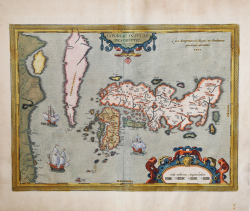
Example from the rare Italian edition of Theatrum Orbis Terrarum printed in Antwerp by Jean Baptiste Vrients in 1608 and then in 1612.
Etching with fine original colouring, good condition.
Bibliografia
Cortazzi 1983; pl. 25; Cortesão and Teixeira da Mota 1960 II: 128; Hessels 1887: letter 210; "Map Collector Circle" 36:2; Lutz Walter (1994) "Japan, a cartographic vision", p. 41, p. 212 map 5; Karrow 1993: 1/198; Van den Broecke 1996: map 165; Van der Krogt 2003: map [8450:31]; Jason H. Hubbard, Japoniae Insulae The Mapping of Japan, n. 6.
Abraham ORTELIUS (1528 - 1598)
|
Abraham Ortel, better known as Ortelius, was born in Antwerp and after studying Greek, Latin and mathematics set up his business there with his sister, as a book dealer and 'painter of maps'. Travelling widely, especially to the great book fairs, his business prospered and he established contacts with many sultured men in many lands. On one such visit to England, possibly seeking temporary refuge from religious persecution, he met William Camden whom he is said to have encouraged in the production of the Britannia.
A turning-point in his career was reached in 1564 with the publication of a World Map in eight sheets of which only one copy is known: other individual maps followed and then - at the suggestion of a friend - he gathered together a collection of maps from contacts among European cartographers and had them engraved in uniform size and issued in 1570 as the Theatrum Orbis Terrarum (Atlas of the Whole World). Although Lafreri and others in Italy had published collections of 'modern' maps in book form in earlier years, the Theatrum was the first uniformly sized, systematic collection of maps and hence can be called the first atlas, although that term itself was not used until twenty years later by Mercator.
The Theatrum, with most of its maps elegantly engraved by Frans Hogenberg, was an instant success and appeared in numerous editions in different languages including addenda issued from time to time incorporating the latest contemporary knowledge and discoveries. The final edition appeared in 1612. Unlike many of his contemporaries Ortelius noted his sources of information and in the first edition acknowledgement was made to eighty-seven different cartographers.
Apart from the modern maps in his major atlas, Ortelius himself compiled a series of historical maps known as the Parergon Theatri which appeared from 1579 onwards, sometimes as a separate publication and sometimes incorporated in the Theatrum.
1570 Theatrum Orbis Terrarum 1570-1612 Between these years the Theatrum was re-issued in 42 editions with 5 supplements with text in Latin, Dutch, German, French, Spanish, Italian and English. The English edition was published in 1606 by John Norton, the maps being printed in Antwerp and the text added in London. Three years later Ortelius died in 1598, his heirs transferred publication rights to Jan Baptiste Vrients who produced the posthumous editions until he died in 1612
1577-85 Spiegel der Werelt (8vo) Maps from the Theatrum, reduced in size, engraved by Philip Galle: text by Pieter Heyns. 6 editions with Dutch, French and Latin text. 1588-i 603 Epitome theatri orbis terrarum (12mo/8v0) 11 further editions of the smaller maps with an increasing number of maps with text also in Italian and English (1603). i6oi-i 2 7 further editions with improved engravings by Arsenius Brothers: text by Michel Coignet in Latin, French, German, Italian and English (1603). 1598-1724 Theatro del Mondo (4t0/12mo/24mo) 8 editions with Italian text; plates engraved in Italy.
1579-1606 Parergon Theatri The number of maps included in the Parergon increased from 4 in 1579 to 43 in 1606 with text in Latin, French, Italian, German and English (1606) 1624 Re-issued in Antwerp as a separate publication by Balthasar Moretus. This edition included a reproduction of the Peutinger table.
|