

| Reference: | s44873 |
| Author | Antonio ZATTA |
| Year: | 1785 |
| Zone: | Japan |
| Printed: | Venice |
| Measures: | 425 x 325 mm |


| Reference: | s44873 |
| Author | Antonio ZATTA |
| Year: | 1785 |
| Zone: | Japan |
| Printed: | Venice |
| Measures: | 425 x 325 mm |
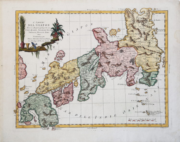
Striking example of Zatta's map of Japan, from his monumental 4 volume Atlante Novissimo.
Japan is divided into its 7 principal provinces, and shows towns, rivers, islands, lakes, mountains, etc.
Includes decorative cartouche.
Map from the Atlante novissimo, illustrato ed accresciuto sulle osservazioni e scoperte fatte dai più celebri e più recenti geografi. Printed in four volumes by Antonio Zatta between 1779 and 1785.
Atlas among the most beautiful and complete ever published in Italy in the eighteenth century, the most famous work of Zatta.
The Atlante Novissimo, as also specified in the title, is “increased on the observations made by the most famous and most recent geographers”. Among the most significant innovations there is the appearance of the new islands discovered in the Pacific Ocean by James Cook and the first Italian map of New Zealand. The illustrations were designed and drawn by his collaborators Giovanni Marco Pitteri, Anton Friedrich Busching, Pietro Antonio Novelli and engraved by Giuliano Zuliani.
The first volume of the atlas is introduced by a brief essay of general geography where the author defines in a concise and precise way the elements that make up the ecliptic and equatorial grids used in the tables. Interesting is the section where he pauses to describe the phenomenon of precession of the equinoxes and the cyclical variation of the obliquity of the ecliptic.
“Zatta based his map on Gilles Robert de Vaugondy's map of 1750, scaling it down to two-thirds the size of the original. In doing so, he conveniently left out all but a small portion of the southeast corner of Korea, all of Hokkaidō and the speculation as to what lay to the north of Japan. Valerio (1988) comments that, in the introduction to the atlas the "...compiler (or compilers) proceeded to criticize all... other contemporary works... including the fact that some of the more recent works... put down the Nation... by having been published in a foreign language, an allusion to Remondini's re-publication of Santini's atlas".
Valerio adds that Giovanni Pitteri (1702-1786) was an engraver who produced the lettering for Zatta's maps.
Zatta was granted the copyright for the Atlante Novissimo in 1773 and it was published over a ten-year period. The dates of the four volumes in the example in the British Library are 1775, 1782, 1784 and 1785, respectively; the map is the twelfth in the sequence in volume 4. There were, however, several editions and volume dates can vary. Valerio (1988) writes that there are "editions... with different collations and dates on maps" but the present author is not aware of any changes, date or otherwise, to the map of Japan. Shirley (2004), after Valerio (1990), writes that the atlas was designed to accompany the Nuova Geografia, an Italian translation of Anton Friedrich Büsching's geographical treatise. Valerio (1997) cites a copy described in F. Wawrik, Berühmte Atlanten, 2., ergänzte Aufl. (Dortmund: Harenberg, 1989) with volumes dated 1779, 1782, 1784 and 1785, the same as Phillips 650; a second copy in the Library of Congress, Phillips 651 is made up of volumes dated 1779, 1785, 1785 and 1785." (Hubbard "Japoniae Insulae – The Mapping of Japan", p. 383).
Etching, printed on contemporary laid paper, with fine later hand colour, in good condition.
Bibliografia:
Hubbard "Japoniae Insulae – The Mapping of Japan", pp. 383-384, n. 120; Walter, "Japan a cartographic vision", p. 225, n. 119.
Antonio ZATTA (Venezia 1722 - 1804)
|
Antonio Zatta (1775-1797) was the most prominent Italian map publisher of the late 18th and early 19th century. His firm, based in Venice, produced maps that mark an important transition from 18th to 19th century cartographic styles. He updates and redefines the traditional title cartouche by replacing the mythic elements common to the 17th and 18th century with more representative images of Venice. His most important work is the four volume Atlante novissimo published from 1775 to 1789.
|