

| Reference: | S31486 |
| Author | Giovanni Maria CASSINI |
| Year: | 1797 |
| Zone: | Korea & Japan |
| Printed: | Rome |
| Measures: | 500 x 370 mm |


| Reference: | S31486 |
| Author | Giovanni Maria CASSINI |
| Year: | 1797 |
| Zone: | Korea & Japan |
| Printed: | Rome |
| Measures: | 500 x 370 mm |
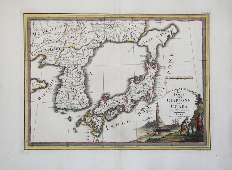
Important and decorative map of Japan and Korea. It features a very unusual, almost triangular representation of “Jeso-Gasima,” the semi-mythical island north of Japan. The title is found within a decorative cartouche.
Taken from the “Nuovo Atlante Geografico Universale delineato sulle ultime osservazioni”, published in Rome from 1792 until 1801, a work that the Camerale Calcografia commissioned from Cassini in order to replace the now obsolete ’Mercurio Geografico.”
Giovanni Maria Cassini was a geographer and cartographer, as well as a carver of architecture and perspective-one of the best disciples of Giovanni Battista Piranesi-Cassini was one of the last Italian spherographers of the 18th century and his globes had a considerable circulation, as did this “Nuovo Atlante Geografico.”
Cassini's Atlas was reprinted by the Camerale Calcografia in the first quarter of the 19th century, before 1839. Only first edition copies such as this one are printed on coeval laid paper and are hand-colored at the time. Nineteenth-century printings are already on mechanical paper, without wirewalls, and generally in black and white.
“Cassini has used Jean-Baptiste Bourguignon d'Anville's representation of the main islands of Japan, including Hokkaidō, from Carte Générale de la Tartarie Chinoise... M.D.CC.XXX11 (1735). Giovanni Maria Cassini (1745-c.1824) was a draughtsman and engraver working in Rome at the end of the eighteenth century. He studied with Giovanni Battista Piranesi and specialized in architectural drawings and perspectives. Between 1787 and 1801 he edited and engraved 182 maps for his three-volume atlas. "...the complete set of copperplates...is still preserved in the Calcografia Nazionale in Rome..." (Valerio 1997). There are at least two editions of Cassini's Nuovo Atlante Geografico Generale. the first, with the three volumes dated 1780, 1797 and 1801; and the second dated 1792, 1797 and 1801. The map originally was placed in the second volume, without numbering, and in the later edition was moved to volume 3 where it was placed 10th in the order of maps” (cf. Hubbard "Japoniae Insulae – The Mapping of Japan", p. 393).
Copperplate with fine later hand colour, very good condition.
Bibliografia:
J. Hubbard "Japoniae Insulae – The Mapping of Japan", pp. 393-394, n. 125; Walter, 53.
Giovanni Maria CASSINI (1745 - 1824)
|
Giovanni Maria Cassini was a fine Italian engraver, globe maker and painter. He did most of his work in Rome, and was not a member of the French Cassini family (a French Giovanni Maria Cassini was bor 120 years earlier). In 1792 Cassini published in Rome Vol. 1 of his atlas Nuovo Atlante Geografico Universale. This contained two celestial hemispheres printed in 1790, which were labeled Planisfero Celeste Settentrionale and Meridionale. Similar to Zatta's hemispheric prints, in the corners were beautiful drawings of famous observatories: Collegio Romano, Bologna, Milan and Padua in the northern plate, and Paris, Cassel, Greenwich and Copenaghen in the southern plate. Vol. 2 of this atlas was published in 1797, Vol. 3 in 1801.
|