

| Reference: | S46074 |
| Author | Johannes Baptiste VRIENTS |
| Year: | 1608 |
| Zone: | Liguria |
| Printed: | Amsterdam |
| Measures: | 540 x 395 mm |


| Reference: | S46074 |
| Author | Johannes Baptiste VRIENTS |
| Year: | 1608 |
| Zone: | Liguria |
| Printed: | Amsterdam |
| Measures: | 540 x 395 mm |
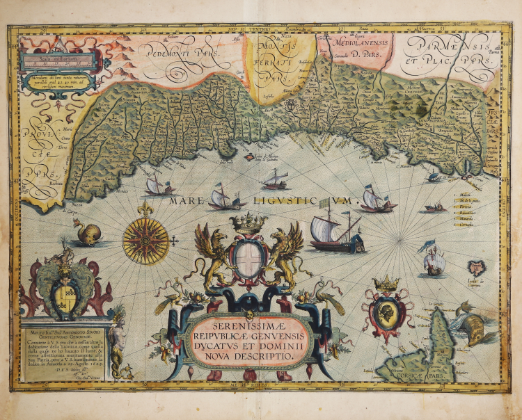
Title in the cartouche at the center: SERENISSIMÆ | REIPVBLICÆ GENVENSIS | DVCATVS ET DOMINII | NOVA DESCRIPTIO. Bottom left: MOLTO ILL.RE SIG.R ANTONIO SIVORI | GENTILHUOMO GENOVESE. | Conuiene à v.s. piu che à nessum 'altro la | dedicatione della LIGVRIA, come quella | dalla quale ne ho hauuto il lume, & | come affettionata meritamente alla | sua Patria, pero à V.S. humilmente la | dedico, in Anuersa a 29 Agosto 1608. | D.V.S. Molto Ill.re | aff.mo Ser.e | Gio. Bat.ta Vrints.
This is a beautiful example of the map of the Republic of Genoa by Jan Baptista Vrients, added to Ortelius' Theatrum Orbis Terrarum in 1608. Taken from the rare Italian edition of Theatrum Orbis Terrarum printed in Antwerp by Jean Baptiste Vrients in 1608 and again in 1612.
According to Peter Meurer, the map is a compilation of Giovanni Antonio Magini's 1597 maps of eastern and western Liguria. These would be his very rare first edition maps, issued separately and not those later found in his son Fabio Magini's Italia (1620): the "Liguria overo Riviera di Genova Occidentale" and the "Liguria overo Riviera di Genova di Levante." However, Vrients did not faithfully capture them; the coastline presented is significantly less concave than that shown accurately in Magini's maps. It seems that Vrients wanted the map to be visually more consistent with Ortelius' map of Piedmont, which was in accordance with Gastaldi's authoritative mid-sixteenth-century maps. Specific details along the Ortelius/Gastaldi coastline, such as bays, rivers and headlands, were instead replaced with those from Magini's 1597 work.
The map reflects a period of great financial and political power for the Republic of Genoa. During the 16th century, many Genoese aristocratic families amassed enormous fortunes through banking and trade, largely related to the exploration and exploitation of the New World. The Spanish Empire, in particular, relied on Genoese financiers in the second half of the 16th century and the first quarter of the 17th. The Genoese merchant nobility consequently became patrons of the arts-an example might be the dedicatee of the present map, "Sigr. Antonioto Sivori" (a "Genoese Gentleman" whose name seems not to have survived in any other historical document but this dedication). Indeed, the dedication to Sivori is superb: a plinth surmounted by the family arms and surrounded by a banded motif and brightly colored leaves, featuring a mermaid crowned with clams and crab legs. The center is dominated by a bold title cartouche, surmounted by the Genoese arms and two griffins. In addition to the Ligurian coast, the northern part of the island of Corsica is included at lower right. It is accompanied by the "Moorhead" of the Corsican armies. The sea is engraved with a striped pattern, rhumb lines and a superb compass rose. The Ligurian sea is sailed by six large Genoese galleys and two other sailing ships. Two sea monsters roam the coasts of Nice and Corsica.
This map was engraved in 1608, by or for Jan Baptista Vrients, for inclusion in Ortelius' Theatrum, which Vrients continued to publish as Ortelius' executor. Therefore, it appeared only in the final four editions of Ortelius' atlas and is consequently one of the scarcest maps among those appearing in that work. It constitutes the pinnacle of decorative cartography and ranks among the most lavishly engraved maps. As is well known, Ortelius' atlases printed by Vrients enjoyed the highest quality hand coloring, and the present map is an example of this: the coloring of the cartouches, compass roses, and ships is particularly rich.
Johannes Baptista Vrients (1552-1612) was a Flemish engraver, publisher and cartographer. Not much is known about his early life, but it is assumed that he grew up as an apprentice among the cartographers of Antwerp, where the guild appointed him master in 1575. In the 1590s he executed maps of the world for Plancius and Linschoten. In 1600 he became executor of Ortelius' will and acquired the plates of the Theatrum after the cartographer's death. Between 1606 and 1612 he published more editions of Ortelius' atlas. Vrients also acquired De Jode's Speculum plates around 1600. Vrients' editions of the Theatrum were published not in Antwerp (the city had fallen during the Dutch war with Spain) but in Amsterdam.
Etching with magnificent contemporary coloring, perfectly executed restorations to the white side margins, otherwise in excellent condition.
Bibliografia
M. van den Broecke, M. Ortelius Atlas Maps: An illustrated Guide n. 126.
Johannes Baptiste VRIENTS (1552 - 1612)
|
Vrients was the map engraver and publisher in Antwerp who, after the death of Ortelius in 1598, acquired the publication rights of the Theatrum. Between 1601 and 1612 he issued a number of editions which included some of his own maps and he was responsible for printing the maps for the English edition in 1606. He also published a number of important individual maps and a small atlas of the Netherlands.
|