| Reference: | S48074 |
| Author | Panfilio Vinzoni |
| Year: | 1747 |
| Zone: | Genova |
| Printed: | Genua |
| Measures: | 440 x 460 mm |
| Reference: | S48074 |
| Author | Panfilio Vinzoni |
| Year: | 1747 |
| Zone: | Genova |
| Printed: | Genua |
| Measures: | 440 x 460 mm |
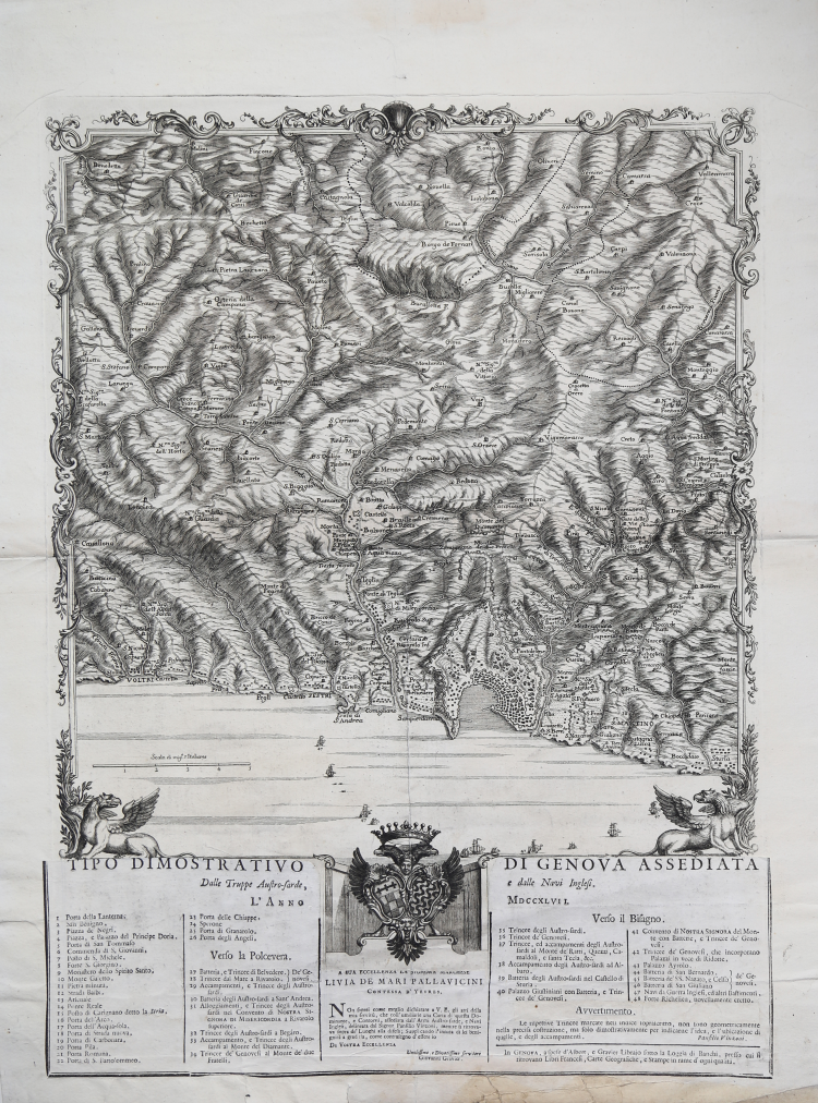
A very rare military map of the city of Genoa and the surrounding area, depicting the siege of the city made by Austrian troops and the British navy in 1747.
Drawn by Ligurian military cartographer Panfilio Vinzoni and printed by Giovanni Gravier. "Avvertimento" signed by Vinzoni and editorial imprint by Gravier at lower right: In GENOVA, a spese d’Abert, e Gravier Librajo sotto la Loggia di Banchi, presso cui si ritrovano Libri Francesi, Carte Geografiche, e stampe in rame d’ogni qualità.
Detailed map of the area between Voltri, Bocchetta and "Sturla" with Bolzaneto in the center (c. 44:41 cm), framed by an ornamental border with coat of arms and 2 Venetian lions at the bottom. Below we find a typographic text, applied above the engraving, with title and numerical key-legend [1-48] to the main sites in the map. Below, the dedication: “A Sua eccellenza la Signora Marchese Livia de Mari Pallavicini Contessa d’Yevres. Non saprei come meglio dichiarare a V. E. gli atti della mia servitù, che coll’umiliarle una Carta di questa Dominante, e Contorni, assediata dall’Armi Austro-sarde, e Navi Inglesei, delineata dal Signor Panfilio Vinzoni, mentre si trovava sopra de’ Luoghi alla difesa; Supplicando l’innata di lei benignità a gradirla, come contrassegno d’essere io. Di Vostra Eccellenza Umilissimo, e Divotissimo servitore Giovanni Gravier”.
The Siege of Genoa is one of the battles of the War of Austrian Succession, which took place in 1747. It took place in 1747, when the Austrian army under the command of Count Schulenburg unsuccessfully attempted to capture the capital of the Republic of Genoa. The Austrians had captured and then lost Genoa the previous year and made it the focus of their strategy for 1747, before planning further operations against Naples or an invasion of France. Schulenberg's troops reached the outskirts of the city in April, but then required additional troops from an ally. Twelve battalions of Sardinian infantry arrived in June. This delay allowed the arrival of French and Spanish troops under Joseph Marie, duke of Boufflers, to reinforce the garrison. The arrival of additional French-Spanish troops under Marshal Belle-Ile and Spanish General La Mina forced the Sardinians to retreat to try to defend Milan from a possible threat. Schulenberg was forced to abandon the siege, blaming the Sardinians. The failure of the siege led to mutual accusations between Vienna and Turin. Both sides began to complain to their British allies about the alleged treachery.
Panfilio Vinzoni (news 1663 -1762), an established cartographer and topographer of the Republic of Genoa in the 17th century, and his son Matteo (1690-1773) were natives of the village of Montaretto in the province of La Spezia. Together they collaborated in the production of valuable geographical and topographical maps for the Genoese republic, thanks in part to the numerous studies on the geography and geology of the territory that their son Matteo preferred to carry out before drawing up a map on a particular area. It was precisely this peculiarity of his to travel to the area and thus delve into all its geographical aspects that contributed to the fame of Matteo Vinzoni, who became the official cartographer of the Republic of Genoa as well as a servant-functionary of the Genoese state itself; however, the spontaneous service he rendered to the Ligurian government was not, according to some sources, reciprocated with adequate economic rewards by the Genoese senate. Together they presented the government with an atlas on the Riviera, entitled Il Dominio della Serenissima Repubblica di Genova in terraferma, accompanied by accurate maps of coastlines, urban centers and fortresses.
Giovanni Gravier (Marseille? - Naples 1770) was a bookseller and publisher of French origin (probably from Marseille) who settled in Italy. First in Genoa, where he had a workshop at the Loggia dei Banchi, and then in Naples.
Etching, printed on contemporary laid paper, with margins, very good condition. Very rare.
Bibliografia
cfr. Massimo Quaini, Levanto nella storia. I – Dall’archivio al territorio. Matteo e Panfilio Vinzoni, Genova, Compagnia dei Librai-Comune di Levanto, 1987 [1988].
Panfilio Vinzoni (notizie 1663 - 1762)
|
Panfilio Vinzoni (news 1663 -1762), an established cartographer and topographer of the Republic of Genoa in the 17th century, and his son Matteo (1690-1773) were natives of the village of Montaretto in the province of La Spezia. Together they collaborated in the production of valuable geographical and topographical maps for the Genoese republic, thanks in part to the numerous studies on the geography and geology of the territory that their son Matteo preferred to carry out before drawing up a map on a particular area. It was precisely this peculiarity of his to travel to the area and thus delve into all its geographical aspects that contributed to the fame of Matteo Vinzoni, who became the official cartographer of the Republic of Genoa as well as a servant-functionary of the Genoese state itself; however, the spontaneous service he rendered to the Ligurian government was not, according to some sources, reciprocated with adequate economic rewards by the Genoese senate. Together they presented the government with an atlas on the Riviera, entitled Il Dominio della Serenissima Repubblica di Genova in terraferma, accompanied by accurate maps of coastlines, urban centers and fortresses.
|