| Reference: | S35104 |
| Author | Vincenzo LUCHINI |
| Year: | 1556 ca. |
| Zone: | Lombardia |
| Printed: | Rome |
| Measures: | 475 x 290 mm |
| Reference: | S35104 |
| Author | Vincenzo LUCHINI |
| Year: | 1556 ca. |
| Zone: | Lombardia |
| Printed: | Rome |
| Measures: | 475 x 290 mm |
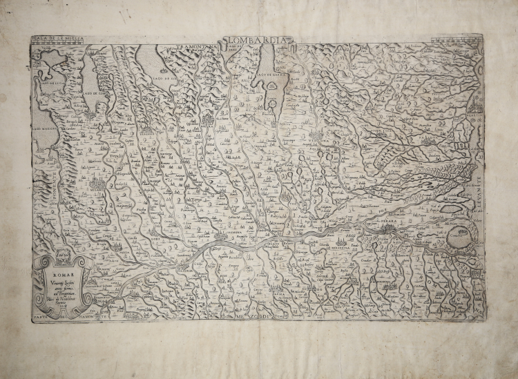
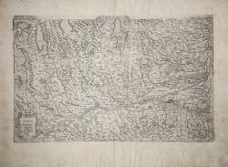
The title of the map, LOMBARDIA, is inscribed within a decorative drapery positioned outside the top margin. In the lower left corner, a scroll shield surmounted by a lion's head contains, below, the date 1558 and the editorial imprint editoriale ROMAE Vincenty Luchini areis formis ad Peregrinum. Petri de Nobilibus Formis. At top corners, divided into two equal parts, is SCALA DE LE MIGLIA (40 miles = mm 108). Orientation in the four sides in the center with the names of the winds: TRAMONTANA, MEZODI, LEVANTE, PONENTE, north being at the top.
First copper derivation of Lucantonio degli Uberti's model, printed in Rome with the date 1556. The map of the region attributed to Luca Antonio de Hubertis (Uberti), constitutes the earliest known printed cartographic representation of northern Italy today. It is probable that the map is, in turn, based on the Florentine engraving, now lost, described as una forma di lombardia, in due fogli chomuni, di rame” in the inventory compiled by the heirs of the engraver Francesco Rosselli (1527). For the dating of the work we have a sure terminus post quem, namely the depiction on the map of the battle of Marignano (or Melegnano), which took place in 1515. On the other hand, there are no references relating to the Battle of Bicocca (near Milan) in 1522 and the Battle of Pavia in 1525. Therefore, the making of the map occurred after 1515 but before 1522. The many recurring Venetian dialect forms in the toponymy leave no doubt about the Venetian origin of the cartographic document. Despite its title, the map does not include all of Lombardy, and it extends from Milan eastward. The work may be the one that Leonardo da Vinci describes in a brief note in his Codex Atlanticus as come “paesi di Milano a stampa”.
Example of the third state of four described by Bifolco/Ronca: “Carta ispirata all’opera di Luca Antonio degli Uberti, completamente modificata nella rappresentazione dei centri abitati. Si tratta di una carta che ebbe molte ristampe, perché presentava in modo chiaro e leggibile una grande estensione territoriale del Nord Italia, dal Lago Maggiore a Venezia. Molto belle le rappresentazioni in prospettiva delle città: che non sono stereotipi, ma rappresentano una visione “dal vero” della città stessa. Tuttavia, la carta è piena di errori, come ad esempio la latitudine alla quale è rappresentata Trento, che è all’incirca quella del Lago di Garda. La prima stesura della carta non contiene dati editoriali e viene considerata dalla letteratura come opera anonima. In realtà, appare evidente che la carta sia una prova ante litteram della lastra e potrebbe essere stampata sia a Roma che a Venezia. Il secondo stato della lastra, quello a firma del Luchini, è invece stampato a Roma nella sua tipografia di via del Pellegrino. La matrice fu poi acquistata e ristampata da Pietro de Nobili; la troviamo elencata nel catalogo della tipografia (inv. del 23 maggio 1586, n. 96 come “Lombardia”). Un’ulteriore edizione si deve a Francesco de Paoli nel 1648”. (cfr. Bifolco-Ronca, Cartografia e topografia italiana del XVI secolo, p. 1856).
Etching and engraving, impressed on contemporary laid paper with watermark “crown with star” (Woodward nos. 265-275), with margins, traces of glue on verso, otherwise in excellent condition.
The Pietro de Nobili edition can be dated to the period 1585-89. The publisher, by association with Paolo Graziani, owned about one-third of the plates from Antonio Lafreri's printing house. Very rare work, surveyed in only 4 copies according B/R.
Bibliografia
Bifolco-Ronca, Cartografia e topografia italiana del XVI secolo, p. 1856, Tav. 931 III/IV; Almagià (1929): pp. 27-28, tav. XXX; Arrigoni-Bertarelli (1930): n. 3016; Terre di Langobardia (2003): n. 2; Tooley (1939): nn. 346-348; Witcombe (2008): p. 224, n. 6.
Vincenzo LUCHINI (Attivo a Roma 1552- 1566)
|
Book and print dealer and publisher .Active in Rome. In 1559 he gained a papal privilege to open a “cartiera” in Rome. He appears as debtor of Lafreri/Salamanca society at its dissolution in 1563, where he is described as: “librario hic in urbe”. Close connections with Venice.
Single-sheet maps and prints 1556-64.
|