

| Reference: | S41679 |
| Author | Antonio BARBEY |
| Year: | 1697 |
| Zone: | Rome |
| Printed: | Rome |
| Measures: | 583 x 535 mm |


| Reference: | S41679 |
| Author | Antonio BARBEY |
| Year: | 1697 |
| Zone: | Rome |
| Printed: | Rome |
| Measures: | 583 x 535 mm |
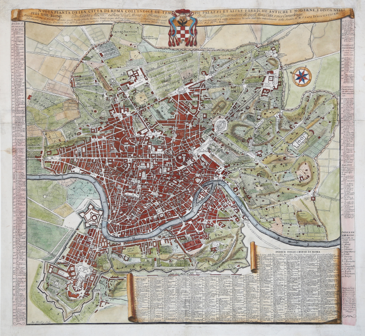
Map of Rome from the 17th century, engraved in Rome by Antonio Barbey and published by Domenico de Rossi.
It is based on the large wall map by Giovan Battista Falda, but shows with particular care the urban interventions under the pontificate of Pope Innocenzo XII, including the sea customs house at Ripa Grande (1694). The map also contains a number of interesting notes and the names of the villas and vineyards within the city walls.
It includes an elegant cartouche with title and coat of arms at the top, and a second cartouche with a long list identifying 464 places of interest in the Eternal City.
The map is oriented north-east at the top and includes ancient and modern sites.
Built-up lots are dotted and the names of many streets are indicated. The general layout and various details indicate that this map derives from Falda's great map, to which Barbey however made numerous updates. In fact, the new interventions of Innocent XII are shown, including the sea customs house at Ripa Grande (1694). The map also contains a series of interesting notes and the names of the villas and vineyards within the city walls. At lower left is written Ant. Barbey Sculp. and on the right Domenico de Rossi [...] the year 1697 the 25th of May. Under the title at the top there is the dedication to Monsignor Ranuccio Pallavicino Governor of this great City and Vice Camerlengo. On both sides a legend with 464 reference numbers and a list of the XIV districts, and, at the bottom right, the index of the churches of Rome (cf. Marigliani p. 253).
Copper engraving with fine later hand colour, few repaired paper folds, otherwise in good condition. Rare.
Bibliografia
Frutaz n. 162, Scaccia Scarafoni n. 206, Huelsen n. 135; Marigliani n. 159.
Antonio BARBEY (attivo tra il 1690 ed il 1714 circa)
|
Map engraver of Dutch or Flemish origins who worked in Rome. He worked for Giovan Battista and Domenico De Rossi, and engraved some of the maps for the "Mercurio Geografico".
|
Antonio BARBEY (attivo tra il 1690 ed il 1714 circa)
|
Map engraver of Dutch or Flemish origins who worked in Rome. He worked for Giovan Battista and Domenico De Rossi, and engraved some of the maps for the "Mercurio Geografico".
|