| Reference: | S48757 |
| Author | Herman MOLL |
| Year: | 1720 ca. |
| Zone: | Mediterranean Sea |
| Printed: | London |
| Measures: | 450 x 315 mm |
| Reference: | S48757 |
| Author | Herman MOLL |
| Year: | 1720 ca. |
| Zone: | Mediterranean Sea |
| Printed: | London |
| Measures: | 450 x 315 mm |
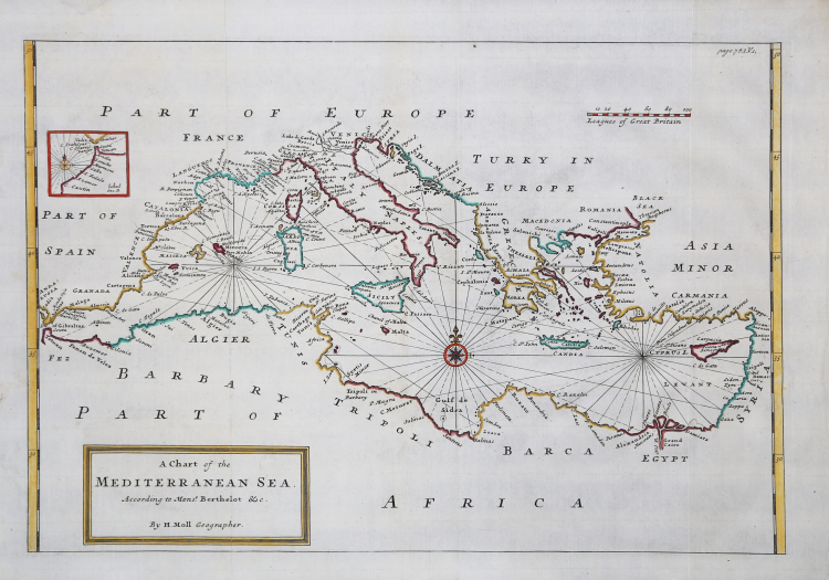
Beautiful map of the Mediterranean signed in the cartouche with the title: By H. Moll Geographer.
Nautical map signed by Hermann Moll, who calls himself a “geographer” and, therefore, may be the compiler, as well as the engraver, of the work.
Herman Moll (1654 - 1732) was one of the most important publishers devoted to the map trade in England in the late 17th and early 18th centuries. It seems likely that he came from Germany, perhaps Bremen, and was in London as early as 1678. The little biographical information is deduced from his considerable output of cartographic material, the result of the activity to which he devoted himself-as was the custom at the time-as an engraver, draughtsman and publisher. Since his death in 1732, there have been no further traces of the Moll publishing house; his son Gilles Hendrick passed away, in fact, prematurely, while his daughter, Henderina Amelia Moll, is little more than a testamentary name. The earliest records of Moll are for 1678 where, as an engraver, he worked for the English Atlas of Moses Pitt and Sir Robert Hooke, one of the project's supporters. Much of his career was devoted to working as an engraver for map makers and publishers, particularly James Knapton, making maps for travel reports. In 1707 Moll began work on his most famous publication, The World Described, a collection of maps of the world. It was one of the most famous English atlases of the 18th century and took a long time to complete; the atlas was not completed until 1717. Moll used to fill in the blanks of his maps with text panels, often with descriptions of the region depicted; at other times, however, with unflattering comments about his rivals: the English Jeremiah Seller and Charles Price, John Senex, and especially the French Guillaume Delisle. Herman Moll was involved in numerous publications: the Thesaurus Geographicus (1695), later republished in various other forms and expanded to form the Atlas Geographus (1711) the Twenty Four New and Accurate Maps of the Several Parts of Europe (1706) and A New Description of England and Wales (1724). In his will, there is no mention of a stock of printing plates or other business assets. It is likely that much of the material to which his name is attached was owned and financed by other publishers.
Etching, finely hand-colored, in excellent condition.
Bibliografia
S. Bifolco, Mare Nostrum, p. 220, n. 97; cfr. National Maritime Museum, Catalogue of the Library - Vol. Three, Atlas & Cartography, Londra, 1971, pp. 453-458; cfr. The Compleat Plattmaker: essays on Chart, Map and Globe Making in England in the Seventeenth and Eighteenth Centuries, Berkeley, 1978; cfr. S. Tyacke, Chartmaking in England and Its Context, 1500 - 1600, in “History of Cartography”, Chicago, 2007, pp. 1722 – 1753.
|
Herman Moll came to London in about 1678 and worked as an engraver for other publishers, such as Moses Pitt, Greenville Collins. John Adair, and Seller & Price, but soon set up his own business publishing atlases and also separate maps of all parts of the world. His work was varied, ranging from miniature maps to large very decorative wall maps. The first maps engraved by Moll in his own right were prepared for the atlas volume accompanying Sir Jonas Moore’s New System Of The Mathematicks …, in which he began to develop his characteristic engraving style.
Maps in Moll’s large folio atlas, The World Described are clearly printed with large cartouches, enclosing the title and dedication and often with large vignettes. This atlas contained one of the largest world maps of the early eighteenth century to appear in atlas form. Published in 1724 the map is somewhat outdated (despite its author’s claims), showing California as an Island long after the French maps of around 1700 had depicted it as a peninsula. Perhaps his most famous map is the New and Exact Map of the Dominions of the King of Great Britain on ye Continent of North America, depicting the English colonies along the east coast. The map is more popularly called the “Beaver Map”, after the attractive vignette scene showing beavers building dams.
Jonathan Swift, it is said, referred to Moll’s maps in the writing of Gulliver’s Travels, thereby adding greater credibility to his story by ensuring the location of the islands visited by Gulliver could not be disputed.
Moll’s other works include the Atlas Manuale (1709), New and Complete Atlas (1719), the Atlas Minor (1729) and Atlas Geographus (1711-17) in five volumes.
Moll also published a fine series of county maps, in the New Description of England, published in 1724. The maps are famous for their side panels with drawings of architectural remains from the counties. His work was much copied by other publishers and he enjoyed a high reputation.
|
|
Herman Moll came to London in about 1678 and worked as an engraver for other publishers, such as Moses Pitt, Greenville Collins. John Adair, and Seller & Price, but soon set up his own business publishing atlases and also separate maps of all parts of the world. His work was varied, ranging from miniature maps to large very decorative wall maps. The first maps engraved by Moll in his own right were prepared for the atlas volume accompanying Sir Jonas Moore’s New System Of The Mathematicks …, in which he began to develop his characteristic engraving style.
Maps in Moll’s large folio atlas, The World Described are clearly printed with large cartouches, enclosing the title and dedication and often with large vignettes. This atlas contained one of the largest world maps of the early eighteenth century to appear in atlas form. Published in 1724 the map is somewhat outdated (despite its author’s claims), showing California as an Island long after the French maps of around 1700 had depicted it as a peninsula. Perhaps his most famous map is the New and Exact Map of the Dominions of the King of Great Britain on ye Continent of North America, depicting the English colonies along the east coast. The map is more popularly called the “Beaver Map”, after the attractive vignette scene showing beavers building dams.
Jonathan Swift, it is said, referred to Moll’s maps in the writing of Gulliver’s Travels, thereby adding greater credibility to his story by ensuring the location of the islands visited by Gulliver could not be disputed.
Moll’s other works include the Atlas Manuale (1709), New and Complete Atlas (1719), the Atlas Minor (1729) and Atlas Geographus (1711-17) in five volumes.
Moll also published a fine series of county maps, in the New Description of England, published in 1724. The maps are famous for their side panels with drawings of architectural remains from the counties. His work was much copied by other publishers and he enjoyed a high reputation.
|