

| Reference: | GR3041 |
| Author | John OVERTON |
| Year: | 1670 ca. |
| Zone: | Mediterranean Sea |
| Printed: | London |
| Measures: | 860 x 500 mm |


| Reference: | GR3041 |
| Author | John OVERTON |
| Year: | 1670 ca. |
| Zone: | Mediterranean Sea |
| Printed: | London |
| Measures: | 860 x 500 mm |
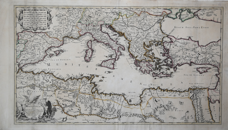
Great map of the Mediterranean published in the Overton Atlas, printed for the first time in 1670. The map is inspired to the one of Guillelme Sanson. ,
John Overton (1640-1713) was a capable publisher who started, in 1670, the revision and sell of maps coming from the production of William Smith, Blaeu, Janssonius, Sanson, Speed and many others. His atlas has been issued six times, every time enriched with new maps, until the final edition published by his son, Henry.
Copperplate, contemporary colour, in excellent condition.
|
The Overton family were leading retailers and publishers of prints and maps in late seventeenth and eighteenth century England.
The first was John Overton (1640-1713) who was apprenticed to Thomas Gould, in the Stationers' Company, and made free on 4th July 1663; some two years later he bought the business of Peter Stent, the leading print and mapseller and publisher of the previous generation, taking over the shop and shop sign. With the foundation of the existing plate stock, Overton built the business up to being the most successful in London at the end of the seventeenth century; while the business depended particularly on the decorative print, architectural and copy book markets, Overton was obviously interested in the maps, commissioning a good range of interesting maps, generally sold separately, sometimes working in conjunction with Philip Lea.
The business passed to his son Henry (I) on 17th June 1707, although the premises went to Henry's sister Sarah; a second son, Philip, received £200 to help him set him up in his own business, on the following 31st July, and two further loans of £100 were made in 1711. A third son, James, received £200 in April 1708, and a further £100 in 1711, but made his future outside the print and map trade.
Henry Overton (I) (1676?-1751) continued the business much as his father, although his output of interesting maps is rather smaller; his major atlas project was a volume of two-sheet maps modelled on Moll’s ‘World Described’ or Senex’s ‘English Atlas’, but it is now rare. He was succeeded by his nephew, Henry (II), who continued the business to about 1764, when the business was sold to Cluer Dicey, a London chapbook and patent medicine seller, who used a national distribution system to sell the maps and prints as separate sheets.
Philip Overton (c.1680-1745) was apprenticed to his father in the Stationers' Company on 2nd December 1695, and made free in 1702. Established in business by his father, he traded principally as a printseller and publisher, specializing in high quality or imported items, portraits and satirical material, with maps as a small part of his stock. Much of his map publishing was done in association with Thomas Bowles, his brother’s major rival. He was succeeded by his widow Mary, who operated the business for three years before it passed to her brother-in-law, Robert Sayer, who took the business to new heights.
|
|
The Overton family were leading retailers and publishers of prints and maps in late seventeenth and eighteenth century England.
The first was John Overton (1640-1713) who was apprenticed to Thomas Gould, in the Stationers' Company, and made free on 4th July 1663; some two years later he bought the business of Peter Stent, the leading print and mapseller and publisher of the previous generation, taking over the shop and shop sign. With the foundation of the existing plate stock, Overton built the business up to being the most successful in London at the end of the seventeenth century; while the business depended particularly on the decorative print, architectural and copy book markets, Overton was obviously interested in the maps, commissioning a good range of interesting maps, generally sold separately, sometimes working in conjunction with Philip Lea.
The business passed to his son Henry (I) on 17th June 1707, although the premises went to Henry's sister Sarah; a second son, Philip, received £200 to help him set him up in his own business, on the following 31st July, and two further loans of £100 were made in 1711. A third son, James, received £200 in April 1708, and a further £100 in 1711, but made his future outside the print and map trade.
Henry Overton (I) (1676?-1751) continued the business much as his father, although his output of interesting maps is rather smaller; his major atlas project was a volume of two-sheet maps modelled on Moll’s ‘World Described’ or Senex’s ‘English Atlas’, but it is now rare. He was succeeded by his nephew, Henry (II), who continued the business to about 1764, when the business was sold to Cluer Dicey, a London chapbook and patent medicine seller, who used a national distribution system to sell the maps and prints as separate sheets.
Philip Overton (c.1680-1745) was apprenticed to his father in the Stationers' Company on 2nd December 1695, and made free in 1702. Established in business by his father, he traded principally as a printseller and publisher, specializing in high quality or imported items, portraits and satirical material, with maps as a small part of his stock. Much of his map publishing was done in association with Thomas Bowles, his brother’s major rival. He was succeeded by his widow Mary, who operated the business for three years before it passed to her brother-in-law, Robert Sayer, who took the business to new heights.
|