

| Reference: | S38510 |
| Author | Anonimo |
| Year: | 1570 ca. |
| Zone: | Eastern Mediterranean |
| Printed: | Venice |
| Measures: | 520 x 345 mm |


| Reference: | S38510 |
| Author | Anonimo |
| Year: | 1570 ca. |
| Zone: | Eastern Mediterranean |
| Printed: | Venice |
| Measures: | 520 x 345 mm |
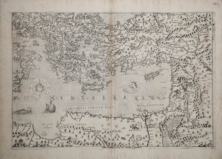
[Eastern Mediterranean Sea] Anon – Venice 1570 circa (but Stefano Mozzi Scolari, Venice 1640-60)
Etching with engraving, printed on contemporary laid paper with "Crown with seven points and letters TB and P" watermark (Woodward 282, founded in another map by Stefano Mozzi Scolari), with margins, very good condition.
A magnific example of the third state, of three, of the SE sheet of the unknown map of Europe, (cf. Bifolco-Ronca, pp. 662-663, tav. 218).
THE ONLY KNOWN COPY of the Scolari's issue. Example from the Fritz Hellwig collection.
In the 16th century collection of the Biblioteca Civica of Bergamo [Atlante_Cinq-7-794] are preserved three sheets, of four, depicting Europe. They are devoid of any printing details and title, which is supposed to be reported on missing quarter. The map is not described by the literature, except for the south-east sheet, that it is already studied by Almagià for the example of the Vaticana; from Valeria Bella for that of the Novacco collection and from Tolias and Zacharakis for that of the collection by Margarita Samourkas.
Almagià defines it as a rough and mediocre map in engraving, inspired from the particular Geographia particolare d’una gran parte dell’Europa (1560) by Giacomo Gastaldi.
He concludes, furthermore, that the map is probably defective of the western sheet, as it shows only eastern Sicily, in which only the last two letters "IA" of the name appear. Then Almagià already assumed that the sheet he analyzed was part of a larger map, ignoring, however, that he composed the European continent.
The date of the work is provided by the flag with the Lion of San Marco that stands above the island of Cyprus; therefore it is prior to 1572, the year in which the island came under Ottoman rule. No other copies of this map are known, as far as we know, it may never have been terminated. The plate on which the south-east sheet was engraved, on the other hand, was later printed by Francesco Valegio, whose imprint appears in the copy illustrated by Tolias (2006). However, Valegio, which does no the even took care of removing the flag with the march symbol on the island of Cyprus, he could have reprinted only the SE sheet. Always from the south-east sheet there is an issue (this one, it’s the only copy known) that bears the imprint of Stefano Scolari; is still present the flag with the symbol of Venice. It is assumed that this was the only sheet that had a reprint.
Literature:
Bifolco-Ronca, Cartografia e Topografia Italiana del XVI secolo, Catalogo ragionato delle opera a stampa (2018), pp. 662-663, tav. 218, III/III.
Almagià (1948): p. 85, n. 5 (foglio di sud-est); Cartografia Rara (1986): n. 84; Tolias (2011): p. 106, II.33, n. 1612; Zacharakis (1992): n. 2759 (all of theme refere only at the SE sheet).
|
Bifolco-Ronca, Cartografia e Topografia Italiana del XVI secolo, Catalogo ragionato delle opera a stampa (2018), pp. 662-663, tav. 218, III/III.
|
Anonimo
|
Bifolco-Ronca, Cartografia e Topografia Italiana del XVI secolo, Catalogo ragionato delle opera a stampa (2018), pp. 662-663, tav. 218, III/III.
|
Anonimo