

| Reference: | VR19OL |
| Author | Johannes VAN KEULEN |
| Year: | 1705 ca. |
| Zone: | Mediterranean Sea |
| Printed: | Amsterdam |
| Measures: | 590 x 530 mm |


| Reference: | VR19OL |
| Author | Johannes VAN KEULEN |
| Year: | 1705 ca. |
| Zone: | Mediterranean Sea |
| Printed: | Amsterdam |
| Measures: | 590 x 530 mm |
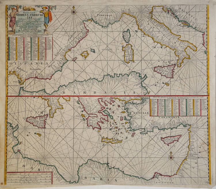
Etching and engraving, 530x590 mm, signed in the cartouche: T’ Amstredam By Iohannes van Keulen Boeckverkooper aende Nieubrugh in de geckroonide Lootsman Mer Privilegie voor 15 Iaaren.
Magnificient example, contemporary old coloured, very good condition.
From: De Nieuwe Groote Lichtende Zee-Fakel, ‘t Derde Deel. Verhoonde de Kunsten van Granaden, Catalonien, Provence, Italien, Dalmatien, Grieken, Thracien, Natolien, Syrien, Egyptne, en de geheele Noordkust van Barbaryen, met alle haer onderhoo rende en tussschen leggende Eylanden. (…) Door Claas Jansz. Vooght, Geometra Leermeester der Wis-konst. Die geen voor de sijnen en kent, als die by Johannes van Keulen gedrukt zijn. t’ Amsterdam, Gedruckt voor Johannes van Keulen, Boeck en Zee-Kaert-verkoper, aen de Nieuw-brugh, in de gekroonde Lootsman. 169[…] . Met Privilegie voor 15 Jaren.
Variant of the Mediterranean map by Johannes I Van Keulen of 1682, which appears for the first time in the Dutch edition of De Nieuwe Groote Lichtende Zee-Fakel. The plate is amended and updated: at the bottom left, the metric scales are now 4 for the addition of the graphic scale in Italian miles. The map is also present in the Italian version of the Zee-Fakel, published in 1705 with the title of Nuova, E Grande Illuminante Face del Mare (see Koeman, AN, IV, p. 346, Keu 108).
Bibliografia: C. Koeman, Atlantes Neerlandici: Bibliography of Terrestrial, Maritime and Celestial Atlases and Pilot Books Published in the Netherlands up to 1880 Vol. IV, Amsterdam 1970, pp. 338-347, Keu 88 A (3) 99; Mare Nostrum, a historic voyage across the Mediterranean Sea, Lussemburgo, 2003, p. 22; cfr. R. Shirley, Maps in the Atlases of the British Library, Londra, 2004, pp. 1200-1213; cfr. D. de Vries, G. Schilder, W. Morzer Bruyns, P. van Iterson, I. Jacobs, The Van Keulen Cartography Amsterdam 1680-1885, Alphen aan den Rijn, 2005.
|
S. Bifolco, "Mare Nostrum, Cartografia nautica a stampa del Mar Mediterraneo" (2020), p. 166, tav. 72.
|
Johannes VAN KEULEN (1654 - 1715)
|
As we have noted in other biographies in this chapter, the Dutch produced a remarkable number of enterprising and prolific map and chart makers but not even the Blaeu and Jansson establishments could rival the vigour of the van Keulen family whose business was founded in 1680 and continued under their name until 1823 and in other names until 1885 when it was finally wound up and the stock dispersed at auction.
Throughout the history of the family, the widows of several of the van Keulens played a major part, after their husbands' deaths, in maintaining the continuity of the business.
The firm was founded by Johannes van Keulen who was registered as a bookseller in Amsterdam in 1678. In 1680 he published the first part of his Zee Atlas which, over the years, was expanded to 5 volumes and continued in one form or another until 1734. More ambitious and with a far longer and more complicated life was his book of sea charts, the Zee-Fakkel, published in 1681-82 which was still being printed round the year 1800. A major influence in the development of the firm was the acquisition in 1693 of the stock of a rival map publisher, Hendrik Doncker.
Although the firm was founded by Johannes van Keulen, he was primarily a publisher; it was his son, Gerard, a talented engraver, mathematician, Hydrographer to the East India Company, who became the mainspring of the business which not only published charts but also books on every aspect of geography, navigation and nautical matters.
|
|
S. Bifolco, "Mare Nostrum, Cartografia nautica a stampa del Mar Mediterraneo" (2020), p. 166, tav. 72.
|
Johannes VAN KEULEN (1654 - 1715)
|
As we have noted in other biographies in this chapter, the Dutch produced a remarkable number of enterprising and prolific map and chart makers but not even the Blaeu and Jansson establishments could rival the vigour of the van Keulen family whose business was founded in 1680 and continued under their name until 1823 and in other names until 1885 when it was finally wound up and the stock dispersed at auction.
Throughout the history of the family, the widows of several of the van Keulens played a major part, after their husbands' deaths, in maintaining the continuity of the business.
The firm was founded by Johannes van Keulen who was registered as a bookseller in Amsterdam in 1678. In 1680 he published the first part of his Zee Atlas which, over the years, was expanded to 5 volumes and continued in one form or another until 1734. More ambitious and with a far longer and more complicated life was his book of sea charts, the Zee-Fakkel, published in 1681-82 which was still being printed round the year 1800. A major influence in the development of the firm was the acquisition in 1693 of the stock of a rival map publisher, Hendrik Doncker.
Although the firm was founded by Johannes van Keulen, he was primarily a publisher; it was his son, Gerard, a talented engraver, mathematician, Hydrographer to the East India Company, who became the mainspring of the business which not only published charts but also books on every aspect of geography, navigation and nautical matters.
|