
| Reference: | MS8009 |
| Author | Girolamo RUSCELLI |
| Year: | 1561 |
| Zone: | Armenia, Georgia |
| Printed: | Venice |
| Measures: | 260 x 195 mm |
| Reference: | MS8009 |
| Author | Girolamo RUSCELLI |
| Year: | 1561 |
| Zone: | Armenia, Georgia |
| Printed: | Venice |
| Measures: | 260 x 195 mm |
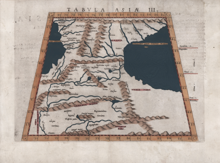
This is a fine example of Ruscelli’s map on trapezoidal projection from his work La Geografia di Claudio Tolomeo Alessandrino. It is based on the work of Ptolemy, and Giacomo Gastaldi, and depicts the region between the The Black Sea and the Caspian Sea, extends into the territory of the Middle East and as far south as Mesopotamia. The map first appeared in the 1561 edition of Ruscelli's edition of Ptolemy's Geografia.
Colchis is in its place on the Black Sea coast, and a large area to the east of Armenia, is labeled Assyriae. Caucasian Albania is in its place to the northwest of the Caspian Sea, with the neighboring Kingdom of Iberia to the west. Centered on present-day Eastern Georgia, it was bordered by Colchis in the west, Caucasian Albania in the east and Armenia in the south. Its population, the Iberians, formed the nucleus of the Kartvelians (i.e. Georgians).
Close to the eastern end of the Caucasus range a defile opens up not far from the shore of the Caspian; this is the Darband pass, called the Gates of Albania and the Caspian Gates by the ancients. Ruscelli has labeled it ‘the Gates of Albania’ along with a vignette of an edifice no doubt intended to represent gates. Cappadocia, which is located in central Turkey is mistakenly shown on the southeastern coast of the Black Sea. The Caucasus Mountains are depicted pictorially and many river systems are denoted. Both seas are stippled. Italian text on the verso describes the areas depicted on the map.
Map taken from Geographia di Claudio Tolomeo edited by Girolamo Ruscelli, published in Venice in several editions between 1561 and 1598. The maps is based on the Geografia by Giacomo Gastaldi (1548), who probably also personally drew these maps, which were engraved by the brothers Livio and Giulio Sanuto.
The peculiarity of these maps is that they are engraved two for plate and subsequently cut; this is why the copper sign only appears on three sides of the map. Ruscelli's text and his maps are considered to be the best modern atlas up to the first version of Abraham Ortelius' Theatrum Orbis Terrarum (1570).
Only their widespread diffusion prevents a sustained evaluation in the antiquarian market. In fact, the work had a first edition in 1561, printed by Vincenzo Valgrisi who also edited the 1562 reprint. There are three editions signed by Giordano Ziletti (two in 1564 and one in 1574), while in 1597 it was published by the Calignani brothers. All these editions contain 64 plates. In 1598 and 1599 the two editions edited by Giuseppe Rosaccio and printed by the heirs of Melchior Sessa came to light. These last two editions include 69 plates; in fact, Rosaccio's map of the planisphere and continents has been added.
Etching and engraving with finel later hand colour, in good condition.
Girolamo RUSCELLI (Viterbo 1504 – Venezia 1566)
|
Girolamo Ruscelli was an Italian humanist, publisher and cartographer active in Venice in the early 16th century. Born in Viterbo, Ruscelli lived in Aquileia, Padua, Rome and Naples before moving to Venice, where he spent most of his life. Cartographically, Ruscelli is best known for his important revision of Ptolemy's Geographia, published in 1561. Based on an expansion of Giacomo Gastaldi's 1548 work Ptolemy, Ruscelli added some 37 new “Ptolemaic” maps to his Italian translation of the Geographia. Ruscelli is also listed as the editor of such important works as Boccaccio's Decameron, Petrarch's verses, Ariosto's Orlando Furioso, and various other works. In addition to his well-known cartographic work, many scholars associate Ruscelli with Alexius Pedemontanus, author of the popular De' Secreti del R. D. Alessio Piemontese. This well-known work, or “Book of Secrets,” was a collection of scientific and quasi-scientific medical recipes, household advice and technical commentary on a range of subjects that included metallurgy, alchemy, dyeing and perfume making. Ruscelli, as Alexius, founded an “Academy of Secrets,” a group of nobles and humanists dedicated to the discovery of “forbidden” scientific knowledge. This was the first known experimental scientific society and was later imitated by numerous other groups throughout Europe, including the Academy of Secrets in Naples.
|