

| Reference: | S45914 |
| Author | Tommaso PORCACCHI |
| Year: | 1572 ca. |
| Zone: | North America |
| Printed: | Venice |
| Measures: | 145 x 110 mm |


| Reference: | S45914 |
| Author | Tommaso PORCACCHI |
| Year: | 1572 ca. |
| Zone: | North America |
| Printed: | Venice |
| Measures: | 145 x 110 mm |
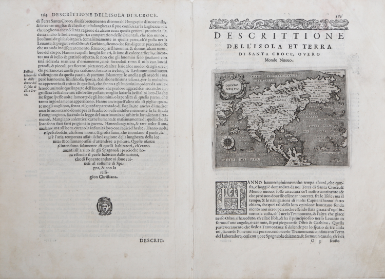
Important map featuring North Central America designed and engraved by Girolamo Porro, for L'Isole più famose del Mondo, a geographical work by Tommaso Porcacchi, first published in 1572.
First state of this fascinating copper-engraved map of the continent based on Paolo Forlani's map. According to Burden, this edition was published in 1576 or 1590, as evidenced by the last line of text above the map that reads "Mondo Nuouo".
The map was drawn by reducing the similar and extremely rare map "Il Disegno del discoperto della nova Franza" engraved and published in Venice by Paolo Forlani and Bolognino Zaltieri in 1565, which in turn was delineated by using among other sources Gastaldi's 1561 world map as shown, for example, by Japan placed in the middle of the Pacific Ocean. The "Descrittione dell'isola & Terra di Santa Croce, overo Mondo Nuovo" is the second-ever depiction of the territories of North Central America.
In Porro's engraving we find the characteristic elements of Forlani's map. The continent is depicted with a very elongated east coast and a strange bulge of the California peninsula peninsula with Giapan (Japan) just offshore. Canada and the Anian Strait, outlet of the mythical Northwest Passage imagined to be north of California, is indicated; east of this the Sierra Nevada range discovered by the Spaniards is specified; part of the course of the Colorado discovered by Francisco Vázquez de Coronado is traced; in the east the San Lorenzo becomes the name of a town overlooking a lake and Ochelaga, an Iroquois village around which Montréal was to be born, is placed further north in the Land of Laborador.
Map taken form “L’isole Piu Famose del Mondo Descritte da Thomaso Porcacchi da Castiglione Aretino e Intagliate da Girolamo Porro Padovan” by Tommaso Porcacchi (ca. 1532-1576), humanist and scholar from Castiglion Fiorentino.
The geographical interests cultivated since Pomponio Mela in 1557 gave life to the treatise published in 1572 by the company between the bookseller Simone Galignani and the Paduan engraver Girolamo Porro, who used the typography of Giorgio Angelieri (with the privilege of 10 years July 1572).
The volume, with a dedication by Galignani to Don Giovanni d'Austria, presents the magnificent calcographic plates by Porro (a second edition, conspicuously augmented with text and tables, came out in 1576, then again, posthumously, in 1590, 1604, 1605, 1620 and 1686). In the dedicatory letter Porro tells of having been the promoter of the operation and of having entrusted Porcacchi with writing a book on the islands, reserving the illustration. The model is that of the "isolari", on which however Porcacchi inserts the spirit of ancient chorographies, adding a physical, historical and cultural description for each island. The concept is very broad (including peninsulas, large islands such as England or entire continents: North America), but in the "Prohemio" Porcacchi provides a glossary of geographical terms that testifies to the effort to correctly use the terminology of the discipline (see Franco Pignatti, Porcacchi Tommaso, in "Dizionario Biografico degli Italiani" - Volume 85, 2016). In the text there are maps of islands engraved on half a page, including the planisphere - reduction of the wall map of Camocio of 1567 and the "carta marina”.
“This finely engraved map appeared in one of the most famous Isolarios produced. It is a reduced rendering of the Paolo Forlani map produced seven years earlier; despite this most of the nomenclature remains. The maps for this atlas were all engraved by Girolamo Porro from Padua, and are set within a page of text. There were later editions of 1576, 1590, 1604, 1605 and 1620. […] the rare final edition of 1686 by Pietro Antonio Brigonci; in it the maps are printed on separate sheets independent from the text. For this edition the plates were retouched, which is clearly distinguished by the darker impression of the main nomenclature." (Burden "The Mapping of North America", p. 55).
Etching and engraving, printed on contemporary laid paper, slight damp mark at top, otherwise in very good condition. Inserted in Porcacchi's descriptive text. This example is preserved with the entire text describing the Mondo Nuovo, as scanned.
Bibliografia:
Burden "The Mapping of North America", p. 55, n. 42; Manasek n. 35.
Tommaso PORCACCHI (1530 - 1585
|
Following Bordone and Camocio, Porcacchi issued in Venice another “Island Book” incorporating later discoveries and including maps of the world and the continents. It continued to appear in new editions for over a century.
1572 L’isole più famose del mondo
|
Tommaso PORCACCHI (1530 - 1585
|
Following Bordone and Camocio, Porcacchi issued in Venice another “Island Book” incorporating later discoveries and including maps of the world and the continents. It continued to appear in new editions for over a century.
1572 L’isole più famose del mondo
|