| Reference: | S46073 |
| Author | Abraham ORTELIUS |
| Year: | 1570 ca. |
| Zone: | Scandinavia |
| Printed: | Antwerpen |
| Measures: | 490 x 365 mm |
| Reference: | S46073 |
| Author | Abraham ORTELIUS |
| Year: | 1570 ca. |
| Zone: | Scandinavia |
| Printed: | Antwerpen |
| Measures: | 490 x 365 mm |
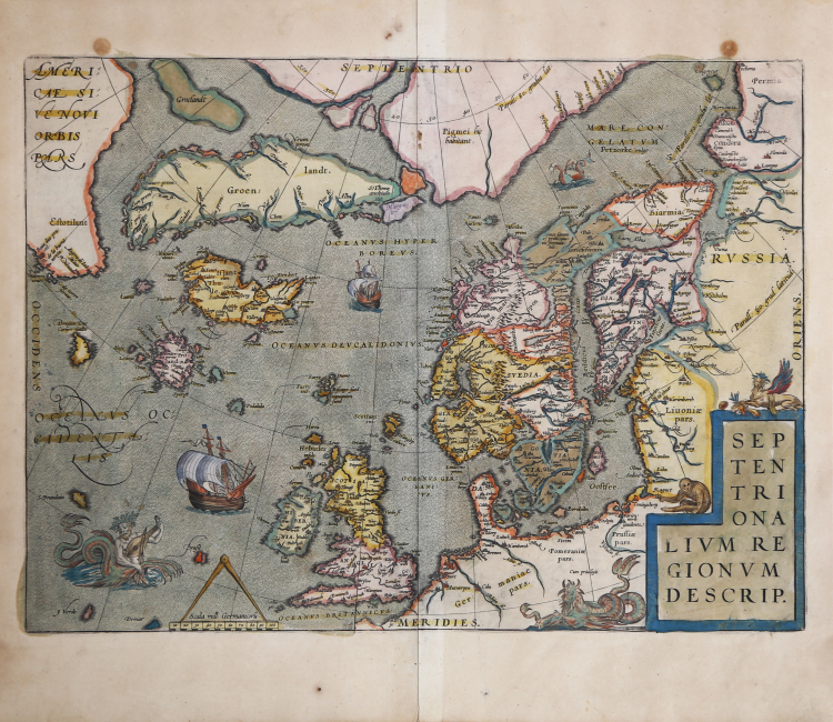
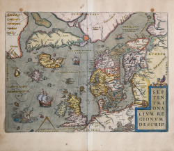
Abraham Ortelius' map of the North Atlantic, engraved by Frans Hogenberg, extends from Scandinavia to the polar regions, Greenland, Iceland and North America, representing a fascinating convergence of knowledge, myths and artistic expressions. The map shows an excellent outline of the Scandinavian coast, bordering the Mare Congelatum and the frozen waters of the Arctic. It is based on Gerard Mercator's 1569 mural map of the World, Zeno's famous 1558 map, and, most importantly, Olaus Magnus' 1539 Carta Marina.
One of the intriguing aspects of Ortelius' map is the depiction of mythical islands that resonated in the popular imagination of the time: Frisland, St. Brandain, Brazil, Icaria and Drogeo.
Ortelius' map is not just a document of exploration, but an artistic creation. It is more than just a geographical representation. It is a historical artifact that encapsulates the scientific knowledge, myths, beliefs and artistic sensibilities of the time. Fusing real geography with fantastical elements, it offers a window into the Renaissance mindset and exploratory zeal of a time when the boundaries of the world were still unexplored. Both as a source of historical study and as a work of art, this map continues to fascinate and inspire, reflecting the timeless human impulse to explore, understand, and imagine.
“Ortelius's map of Scandinavia, one of the fifty-three maps in the first edition of the atlas, is included in all subsequent editions. The "Catalogus auctorum tabularum geographicarum" in the first edition acknowledged eighty-seven cartographers as sources for the maps. Among those cited for the Scandinavia map are Ziegler, Olaus Magnus, Zeno (via the Ruscelli), Algoet, and Monachus (a map of the northern regions, now lost). The influence of both Magnus and Zeno is seen in the map of Scandinavia, particularly in some of the mythical islands in the north Atlantic (e.g., Frisland). Although Ortelius retained the imaginary isle of Icaria west of Iceland, he removed Estland. In other changes, Ortelius placed Estitoland clearly on the mainland of America and made Drogeo unequivocally an island, whereas on the Zeno map they simply run off into the margins. Estitoland may be associated with Labrador, in which case Drogeo may represent Newfoundland.
Ortelius's map extends to about 85° N and does not cover the entire polar region. Nonetheless, the landmasses at the top are unmistakably parts of two of the four main islands that comprised the north pole according to contemporary belief. Mercator's representation of the Arctic on his eighteen-sheet wall map of 1569 influenced Ortelius, even to the extent of copying the words "Pigmei hic habitant" (Here Live the Pygmies) on the southeastern island between 30° and 40° east longitude and just below the 80° latitude line” (cf. William B. Ginsberg, Printed Maps of Scandinavia and the Artic 1482-1601, p. 91).
Example in the sixth state of eight described by Ginsberg, taken from the rare Italian edition of Theatrum Orbis Terrarum printed in Antwerp by Jean Baptiste Vrients in 1608 and later in 1612.
Etching with magnificent original coloring, very good condition.
Bibliografia
William B. Ginsberg, Printed Maps of Scandinavia and the Artic 1482-1601, pp. 91-110, VI/VIII; Van den Broecke #160; Burden #40.
Abraham ORTELIUS (1528 - 1598)
|
Abraham Ortel, better known as Ortelius, was born in Antwerp and after studying Greek, Latin and mathematics set up his business there with his sister, as a book dealer and 'painter of maps'. Travelling widely, especially to the great book fairs, his business prospered and he established contacts with many sultured men in many lands. On one such visit to England, possibly seeking temporary refuge from religious persecution, he met William Camden whom he is said to have encouraged in the production of the Britannia.
A turning-point in his career was reached in 1564 with the publication of a World Map in eight sheets of which only one copy is known: other individual maps followed and then - at the suggestion of a friend - he gathered together a collection of maps from contacts among European cartographers and had them engraved in uniform size and issued in 1570 as the Theatrum Orbis Terrarum (Atlas of the Whole World). Although Lafreri and others in Italy had published collections of 'modern' maps in book form in earlier years, the Theatrum was the first uniformly sized, systematic collection of maps and hence can be called the first atlas, although that term itself was not used until twenty years later by Mercator.
The Theatrum, with most of its maps elegantly engraved by Frans Hogenberg, was an instant success and appeared in numerous editions in different languages including addenda issued from time to time incorporating the latest contemporary knowledge and discoveries. The final edition appeared in 1612. Unlike many of his contemporaries Ortelius noted his sources of information and in the first edition acknowledgement was made to eighty-seven different cartographers.
Apart from the modern maps in his major atlas, Ortelius himself compiled a series of historical maps known as the Parergon Theatri which appeared from 1579 onwards, sometimes as a separate publication and sometimes incorporated in the Theatrum.
1570 Theatrum Orbis Terrarum 1570-1612 Between these years the Theatrum was re-issued in 42 editions with 5 supplements with text in Latin, Dutch, German, French, Spanish, Italian and English. The English edition was published in 1606 by John Norton, the maps being printed in Antwerp and the text added in London. Three years later Ortelius died in 1598, his heirs transferred publication rights to Jan Baptiste Vrients who produced the posthumous editions until he died in 1612
1577-85 Spiegel der Werelt (8vo) Maps from the Theatrum, reduced in size, engraved by Philip Galle: text by Pieter Heyns. 6 editions with Dutch, French and Latin text. 1588-i 603 Epitome theatri orbis terrarum (12mo/8v0) 11 further editions of the smaller maps with an increasing number of maps with text also in Italian and English (1603). i6oi-i 2 7 further editions with improved engravings by Arsenius Brothers: text by Michel Coignet in Latin, French, German, Italian and English (1603). 1598-1724 Theatro del Mondo (4t0/12mo/24mo) 8 editions with Italian text; plates engraved in Italy.
1579-1606 Parergon Theatri The number of maps included in the Parergon increased from 4 in 1579 to 43 in 1606 with text in Latin, French, Italian, German and English (1606) 1624 Re-issued in Antwerp as a separate publication by Balthasar Moretus. This edition included a reproduction of the Peutinger table.
|