| Reference: | S46852 |
| Author | Society for the Diffusion of Useful Knowledge |
| Year: | 1840 |
| Zone: | Pacific Ocean |
| Printed: | London |
| Measures: | 410 x 345 mm |
| Reference: | S46852 |
| Author | Society for the Diffusion of Useful Knowledge |
| Year: | 1840 |
| Zone: | Pacific Ocean |
| Printed: | London |
| Measures: | 410 x 345 mm |
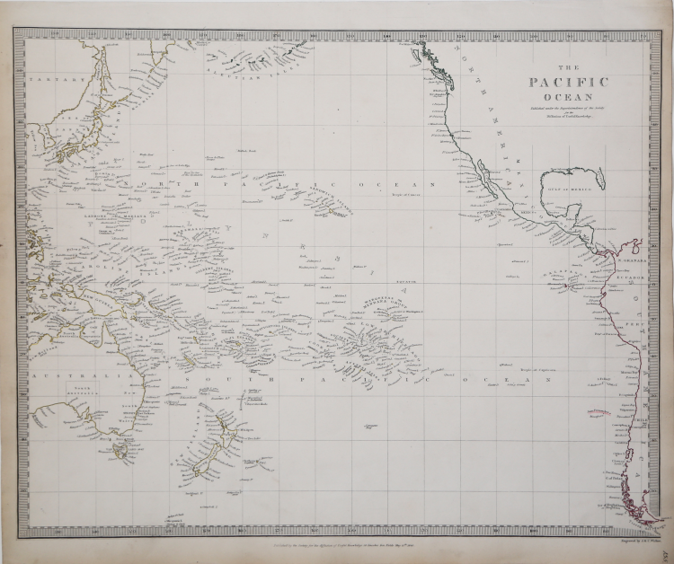
A nice map prepared for the Atlas of the S.D.U.K.
Centered on the Sandwich or Hawaiian Islands, it depicts the entirety of the Pacific Basin along with portions of the surrounding continents. The map covers from the Sea of Okhotsk south as far as Tierra del Fuego and from The Philippines east to Lake Maracaibo. Includes Australia. Although the interiors of the continents remain blank, the coastal regions are highly detailed. Numerous islands of Polynesia, Melanesia and Micronesia are noted along with the years of their discovery. The disputed sea between Japan and Korea is here identified in favor of Japan.
The Society for the Diffusion of Useful Knowledge, or S.D.U.K., as the Society was known, produced inexpensive maps to encourage broad use in education. The maps in these two volumes were issued in parts over several years. The city plans are of particular interest, with vignettes and great detail. Their most important atlas consisted of some 200 separately issued maps, initially published by Baldwin and Cradock and sold by subscription from 1829 to 1844. Later, the Society combined the maps into a single world atlas published under the Chapman and Hall label. At the time, this atlas was unprecedented in quality, scope, and affordability. Today, the Society's maps, or S.D.U.K. as it is commonly called, are among the most impressive examples of mid-nineteenth-century English mass cartographic publishing. S.D.U.K. is best known for its beautiful and accurately detailed city plans.
The first edition being published by Baldwin and Cradock, with the maps issued in numbers and later bound as a set. Engraved by J. & C. Walker. Published by the Society for the Diffusion of Useful Knowledge, 59 Lincolns Inn Fields, Novr. 26th. 1838. (London: Chapman & Hall, 1844).
Steel-engraving with contemporary outline colour, good condition.
Society for the Diffusion of Useful Knowledge (Londra 1826 - 1848)
|
The Society for the Diffusion of Useful Knowledge (1826 - 1848) was a Whiggish organization founded in 1828 on the initiative of English idealist Henry Peter Brougham. The Society's admirable aim was to distribute useful information through a series of publications to the English working and middle classes. It promoted self-education and egalitarian sharing of all knowledge. Although closely associated with the University of London and publishing houses such as Baldwin and Cradock, Chapman and Hall, and Charles Knight, the Society failed to achieve its goals and closed its doors in 1848. Most likely, the failure of the Society was due to the fact that its publications were too expensive for the lower-middle class market for which they were intended, but not large and refined enough to interest the aristocratic market. Nevertheless, the Society managed to publish several extraordinary atlases that were very detailed and sophisticated. Their most important atlas consisted of some 200 separately issued maps, initially published by Baldwin and Cradock and sold by subscription from 1829 to 1844. Later, the Society combined the maps into a single world atlas published under the Chapman and Hall label. At the time, this atlas was unprecedented in quality, scope, and affordability. Today, the Society's maps, or S.D.U.K. as it is commonly called, are among the most impressive examples of mid-nineteenth-century English mass cartographic publishing. S.D.U.K. is best known for its beautiful and accurately detailed city plans.
|