
| Reference: | MS4442 |
| Author | Adolphe Hippolite DUFOUR |
| Year: | 1860 ca. |
| Zone: | Oceania |
| Printed: | Paris |
| Measures: | 740 x 540 mm |
| Reference: | MS4442 |
| Author | Adolphe Hippolite DUFOUR |
| Year: | 1860 ca. |
| Zone: | Oceania |
| Printed: | Paris |
| Measures: | 740 x 540 mm |
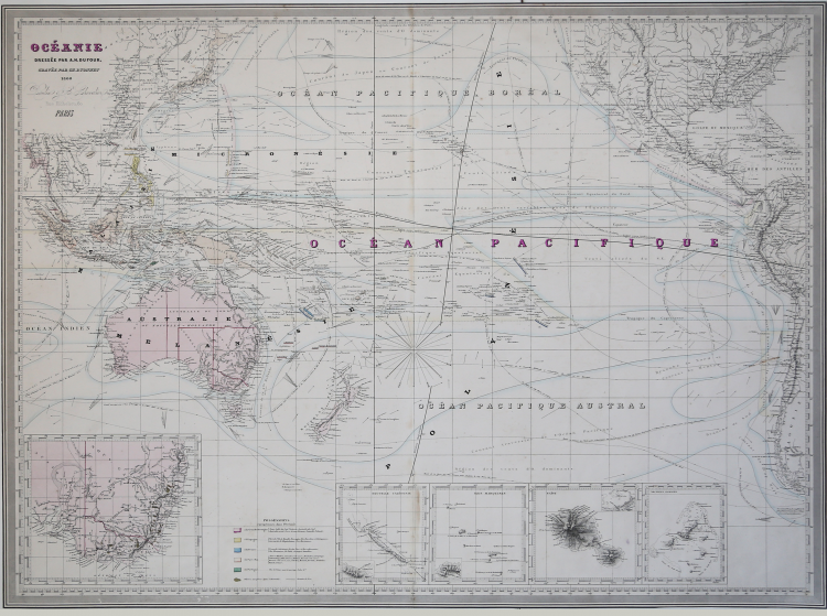
Scarce map of Oceana and the Pacific Ocean, from Dufour's Atlas Universel.
Centered on Hawaii. Includes ocean currents and other details. Inset maps of New Caledonia, Tahiti, and the Marquesas.
This is an impressive 1860 elephant folio map of Australia, New Zealand, Polynesia and the Pacific Ocean by A. H. Dufour. It covers from Burma (Myanmar) east as far as Chile and from Japan south to New Zealand. Although the interiors of the continents remain blank, the coastal regions are highly detailed. Numerous islands of Polynesia, Melanesia and Micronesia are noted. Five insets are features along the bottom border of the map.
These include an inset of New South Wales, Australia, showing gold locations, New Caledonia, Martinique Island, Tahiti and the Gambier Archipelago.The map shows extraordinary detail throughout noting European possessions in Australia and southeast Asia, cities, islands, rivers, lakes, mountains, oceans and ocean currents, sea routes of explorers and a host of other geographical, topographical and physical features.
|
Rumsey 5020.044.
|
Adolphe Hippolite DUFOUR (Parigi 1798 - 1865)
|
Adolphe Hippolyte Dufour (1798 - 1865), also known as Auguste-Henri Dufour, was a Paris based map and atlas publisher active in the mid to late 19th century. Dufour claimed to be a student of another French cartographer, Emile Lapie. His is known to have worked with numerous other cartographers, publishers and engravers of the period including Dyonnet and Duvotenay. In 1824, he first published a geographical analysis of the map of Palestine under his own name, and from then on took part in a series of historical and topographical publications for which he prepared and drew plans and maps. His corpus includes numerous maps and atlases, the most striking of which is probably his monumental 1857 elephant folio Grand atlas Universel physique, historique et politique geographie ancienne et moderne. His main works are: L'atlas élémentaire et universel de géographie ancienne et moderne (1828); Plusieurs Précis de système planétaire et de cosmographie; L'atlas joint à la France illustrée de Victor Adolphe Malte-Brun (1855); L'atlas Dufour, atlas universel, physique, historique et politique de la France, de ses départements et de ses colonies (1857).
|
|
Rumsey 5020.044.
|
Adolphe Hippolite DUFOUR (Parigi 1798 - 1865)
|
Adolphe Hippolyte Dufour (1798 - 1865), also known as Auguste-Henri Dufour, was a Paris based map and atlas publisher active in the mid to late 19th century. Dufour claimed to be a student of another French cartographer, Emile Lapie. His is known to have worked with numerous other cartographers, publishers and engravers of the period including Dyonnet and Duvotenay. In 1824, he first published a geographical analysis of the map of Palestine under his own name, and from then on took part in a series of historical and topographical publications for which he prepared and drew plans and maps. His corpus includes numerous maps and atlases, the most striking of which is probably his monumental 1857 elephant folio Grand atlas Universel physique, historique et politique geographie ancienne et moderne. His main works are: L'atlas élémentaire et universel de géographie ancienne et moderne (1828); Plusieurs Précis de système planétaire et de cosmographie; L'atlas joint à la France illustrée de Victor Adolphe Malte-Brun (1855); L'atlas Dufour, atlas universel, physique, historique et politique de la France, de ses départements et de ses colonies (1857).
|