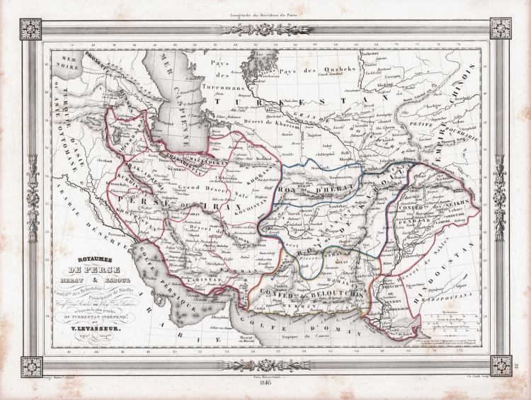
| Reference: | S48915 |
| Author | Victor LEVASSEUR |
| Year: | 1846 |
| Zone: | Persia |
| Printed: | Paris |
| Measures: | 335 x 255 mm |
| Reference: | S48915 |
| Author | Victor LEVASSEUR |
| Year: | 1846 |
| Zone: | Persia |
| Printed: | Paris |
| Measures: | 335 x 255 mm |
Map prepared by Victor Levasseur for publication in Maison Basset's 1848 edition of Atlas Illustre Destine a l'enseignement de la Geographie elementaire.
Maison Basset (1819 - 1865) was a French publishing concern active through the mid to late 19th century. The firm can trace their roots to André Basset (or Bassett) (fl. 1768 - 1784), who starting publishing maps, prints, and books around 1768. Maison Basset, also Chez Basset, is the imprint under which the heirs of Paul-André Basset (1785 - 1819) published the works of such prominent French cartographers and engravers as Barbie du Bocage, A. Vuillemin, J. B. Charle, V. Levasseur, Tu. Duvotenay, H. Dufor, F. E. George, and others. Their library of publications is diverse and vast, but heavily focused on medical and scientific texts, including several important atlases.
Victor Levasseur was an engineer-geographer and surveyor employed by the Engineering Department of the Cadastre and City of Paris in the mid-19th century. The son of Brigadier General Victor Levasseur, he is best known for his large Atlas (National) Illustré des 86 (89 après 1859) Départements et des Possessions de La France showing French departments and French colonies in America, Africa and Asia. His cartographic works and statistics are appreciated today more for the characteristic decorations surrounding the maps than for the details of the maps themselves.
Copper engraving with original outline colour, some foxing, otherwise good condition.
|
Victor Levasseur, born Dec. 8, 1800, in Caen and died Feb. 4, 1870, in Paris, was an engineer-geographer and surveyor employed by the Engineering Department of the Cadastre and City of Paris in the mid-19th century. The son of Brigadier General Victor Levasseur, he is best known for his large Atlas (National) Illustré des 86 (89 après 1859) Départements et des Possessions de La France showing French departments and French colonies in America, Africa and Asia. His cartographic works and statistics are appreciated today more for the characteristic decorations surrounding the maps than for the details of the maps themselves. The hand-colored boundary maps (up to 1859) are a treasured memento of the 19th century, surrounded by engravings with statistics, historical notes, and characteristic illustrations of the departments and colonies. The maps show roads, railroads, and waterways; the departments are divided into arrondissements, cantons, and communes; the work is based on the Dépôt de la Guerre and Ponts et Chaussées Cadastre and was widely used in town halls.
|
|
Victor Levasseur, born Dec. 8, 1800, in Caen and died Feb. 4, 1870, in Paris, was an engineer-geographer and surveyor employed by the Engineering Department of the Cadastre and City of Paris in the mid-19th century. The son of Brigadier General Victor Levasseur, he is best known for his large Atlas (National) Illustré des 86 (89 après 1859) Départements et des Possessions de La France showing French departments and French colonies in America, Africa and Asia. His cartographic works and statistics are appreciated today more for the characteristic decorations surrounding the maps than for the details of the maps themselves. The hand-colored boundary maps (up to 1859) are a treasured memento of the 19th century, surrounded by engravings with statistics, historical notes, and characteristic illustrations of the departments and colonies. The maps show roads, railroads, and waterways; the departments are divided into arrondissements, cantons, and communes; the work is based on the Dépôt de la Guerre and Ponts et Chaussées Cadastre and was widely used in town halls.
|