

| Reference: | S41699 |
| Author | Paolo PETRINI |
| Year: | 1717 |
| Zone: | East Indies, Philippinas |
| Printed: | Naples |
| Measures: | 522 x 430 mm |


| Reference: | S41699 |
| Author | Paolo PETRINI |
| Year: | 1717 |
| Zone: | East Indies, Philippinas |
| Printed: | Naples |
| Measures: | 522 x 430 mm |
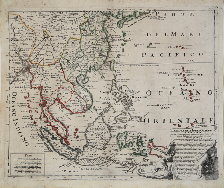
A very rare map--based on one by Nicolas de Fer, published in Paris in the second half of the 17th century--printed in Naples by Paolo Petrini's printer, in 1717.
Centered on the Malay Peninsula, this map covers all of South and Southeast Asia from Persia to the island of Timor, including the modern nations of India, Sri Lanka, Thailand, Burma (Myanmar), Malaysia, Cambodia, Vietnam, Laos, Indonesia, and the Philippines.
In the lower right cartouche, supported by an elephant, we find the indication of derivation from Nicolas de Fer and the imprint "Data in luce da Paolo Petrini in Napoli con Privilegio di S. C. e C. M. l'anno 1717".
This is followed by a description of the populations: "Li abitanti delle Filippine, quando hanno qualche vittoria, sicavano sangue e seolo bevano; abitano sopra li arbori per tema delli animali feroci e serpenti oribili che vené gran quantita; le loro donne sono belle è ben vestite il loro esercito è il filar bonbace" [The inhabitants of the Philippines, when they have some victory, drink blood; they dwell above the trees for fear of the ferocious animals and horrible snakes that came great quantity; their women are beautiful is well dressed their army is filar bonbace].
The map is part of the Atlante Partenopeo, a complex publishing operation put in place by the Neapolitan bookseller and printer Petrini to collect many of the maps he made starting in the last decade of the 17th century, drawn substantially from Guillaulme Sanson, Nicolas De Fer and Giacomo Cantelli, and published with updates also for much of the'700 by his son Nicola.
Petrini's atlas represented for the Kingdom of Naples, the equivalent of the “Mercurio Geografico” printed in Rome by the De Rossi printing house and circulated mainly in the Papal States.
Copperplate engraving, contemporary coloring of the outlines, in excellent condition.
Paolo PETRINI (Attivo a Napoli fine del XVIII secolo)
|
very little is known about Petrini except that for many years he was a publisher and map seller in Naples producine large and small maps often slavishly based on those by Guillaume Sanson and Nicolas de Fer. About 1718 he published a large-scale plan of Naples. All his work is very rare.
1700 Atlante Partenopea
1700 Mappa Mondo Vero Carta
1700 ca. Maps of the wolrd and continents (wall maps)
|