| Reference: | CO-223 |
| Author | Gerard VAN KEULEN |
| Year: | 1680 ca. |
| Zone: | Taranto |
| Printed: | Amsterdam |
| Measures: | 210 x 230 mm |
| Reference: | CO-223 |
| Author | Gerard VAN KEULEN |
| Year: | 1680 ca. |
| Zone: | Taranto |
| Printed: | Amsterdam |
| Measures: | 210 x 230 mm |
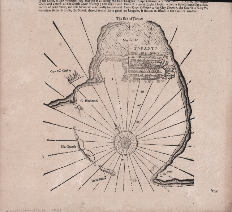
Piano nautico raffigurante il porto di Taranto tratta dall'edizione inglese del "De Nieuwe Groote Lichtende Zee-Fakkel", ovvero un portolano dei mari del mondo pubblicato tra il 1681 e il 1684 in cinque volumi in folio, ai quali - nel 1753 - se ne aggiunse un sesto per la navigazione lungo le coste asiatiche.
Xilografia, in ottimo stato di conservazione.
Gerard VAN KEULEN (1678 - 1726)
|
The Van Keulen dynasty of publishers, printers, booksellers, and cartographers produced the most comprehensive and up-to-date Dutch nautical atlases. Johannes van Keulen (1654–1715) founded a book and instrument business in Amsterdam in 1678 and in 1680 obtained the privilege of printing nautical guides and atlases from Holland and West Friesland. His first major work was the Nieuwe Lichtende Zee-Fakkel, illustrated by Jan Luyken, with maps drawn by Claes Jansz Vooght; five volumes were published between 1681 and 1684. Van Keulen also produced a Zee-Atlas ofte Water-werelt. The Van Keulen family continued to operate for nearly two centuries; Gerard (1678 - 1726) produced new editions of his father's works, numerous manuscript maps, and was appointed hydrographer to the Dutch East India Company (VOC) in 1706; his son Jan II van Keulen (1704 - 1770) took over the business in 1726 and published a new edition of the Asiatic volume of the Zee-Atlas; he was appointed cartographer to the VOC in 1743. After Jan II's death, his sons Cornelis Buijs and Gerard Hulst van Keulen ran the family business. Gerard (1733 - 1801) added a further volume to the Zee-Fakkel containing East India material derived from the VOC. Gerard, in addition to publishing the first nautical almanac in Dutch in 1788, was one of the three original members of the commission established by the Dutch government in 1787 to solve the problem of finding longitude at sea. Gerard's son, Jan III, was the last van Keulen to run the company.
|