
| Reference: | s27297 |
| Author | Gerard MERCATOR (Kremer) |
| Year: | 1589 ca. |
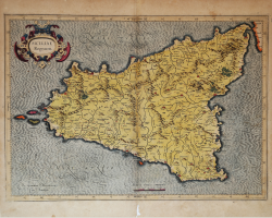
| Zone: | Sicily |
| Printed: | Duisburg |
| Measures: | 470 x 345 mm |
| Reference: | s27297 |
| Author | Gerard MERCATOR (Kremer) |
| Year: | 1589 ca. |
| Zone: | Sicily |
| Printed: | Duisburg |
| Measures: | 470 x 345 mm |
The map is prepared by Gerard Mercator for his Italia, Sclavoniae et Graeciae tabula geographicae (Duisburg, 1589), which includes an allegorical frontispiece and 22 maps of Italy, the Balkans and Greece.
Later, the maps are reprinted in the Atlantis Pars Altera (1595) published posthumously after the death of Mercator, by the Duisburg printer Albert Buys, under the supervision of his son Rumold Mercator. Composed of six parts - published separately between 1589 and 1594 - it includes 107 maps, all except Rumold's map of the world, made by Gerard Mercator.
The plates were then purchased by Jodocus Hondius, who between 1606 and 1630 used them for his Atlas Sive Cosmographicae Meditationes de Fabrica Mundi, integrating and updating them with his own "new" maps. Of Mercator's maps are also known reprints edited by Johannes Janssonius. The Hondius and Janssonius editions had a great commercial success and were printed in several languages, with the text on the back of the map in Latin, French, German and Dutch.
The map is engraved with the typical connotations of Mercatorian work. The mountains are aligned in a mountainous area concept, not to indicate true chains or valleys, and have a structure with some differences in size, but similar in shape, with vertical slopes and flat tops. The cities are shown through more or less large castles characterized by slender and pointed roofs, similar to wizard hats.
“Si tratta della prima carta della Sicilia moderna realizzata da Gerard Kremer (1512-1594) detto Mercatore, ritenuto dagli studiosi il più famoso geografo dopo Tolomeo, la cui bibliografia è tra le più abbondanti nel campo storico cartografico. Basti considerare che la sua prima biografia comparve già nel 1595, nel testo del suo Atlas, un anno dopo la morte. Nacque nel 1512 a Rupelmonde ma seguì corsi universitari a Leuven dove si diplomò nel 1532. Dal 1535 seguì corsi di matematica sotto la guida di Gemma Frisio. Si affermò subito come costruttore di strumenti scientifici e di globi, nonché rilevatore e cartografo. Nel 1537 fu pubblicata la sua prima mappa della Palestina, mentre i suoi primi globi terrestre e celeste sono rispettivamente del 1541 e del 1551.
Nel 1552 si trasferì a Duisburg, per evitare le persecuzioni religiose (era stato in prigione per quattro mesi a Rupelmonde con l'accusa di eresia), e divenne in breve cosmografo al servizio del duca Guglielmo. In questo periodo videro la luce le prime importanti opere cartografiche: una carta murale dell'Europa (1554), una della Lo- rena (1563) e delle isole britanniche (1564) per arrivare, nel 1569, al suo planisfero in proiezione a latitudine crescente (nota come proiezione di Mercatore) che lo consacrerà alla futura memoria. A tale periodo risale anche l'intenzione di realizzare una descrizione completa del- l'Universo: stelle, terra, mare unitamente a una storia del mondo. Il risultato fu il suo primo atlante intitolato Atlas, sive cosmographicae meditationes de fabbrica mundi et fabbricati figura, stampato con tale titolo solo nel 1595, un anno dopo la sua morte, dal figlio Rumold.
Le prime carte di quello che diverrà l'Atlas mercatoriano furono stampate sotto il titolo di Galliae Tabulae geographicae, The seventeene Provinces of the Lowe countries, entrambe nel 1585, e Italiae, Sclavoniae, et Graeciae tabulae geographicae, nel 1589. In questo ultimo volume, compare per la prima volta la "Siciliae Regnum" disegnata da Mercatore. A differenza delle mappe di Ortelius, che utilizzava materiale di altri autori, quelle di Mercatore sono originali e provengono da sue personali osservazioni o elaborazioni.
Il rame fu utilizzato in tutte le successive edizioni del- l'atlante di Mercatore curate da Hondius e Janssonius fino al 1635; a partire dal 1636 il rame risulta modificato nel cartiglio e nel tratteggio del mare e continuò ad essere stampato fino al 1666 circa.” (Valerio-Spagnolo "Sicilia 1477-1861", p. 186).
Copper engraving, in good condition.
Bibliografia
cfr. Koeman II Me 11 e Koeman II Me 13A, 1595); Van der Krogt 1:002; J. Keuning, The History of an Atlas, in “Imago Mundi” IV (1947) pp. 37-43; World Encompassed p. 134; Valerio-Spagnolo "Sicilia 1477-1861", pp. 186-189, n. 54.
Gerard MERCATOR (Kremer) (1512 - 1594)
|
For nearly sixty years, during the most important and exciting period in the story of modern map making, Gerard Mercator was the supreme cartographer, his name, second only to Ptolemy, synonymous with the form of map projection still in use today. Although not the inventor of this type of projection he was the first to apply it to navigational charts in such a form that compass bearings could be plotted on charts in straight lines, thereby providing seamen with a solution to an age-old problem of navigation at sea. His influence transformed land surveying and his researches and calculations led him to break away from Ptolemy's conception of the size and outline of the Continents, drastically reducing the longitudinal length of Europe and Asia and altering the shape of the Old World as visualized in the early sixteenth century.
Mercator was born in Rupelmonde in Flanders and studied in Louvain under Gemma Frisius, Dutch writer, astronomer and mathematician. He established himself there as a cartographer and instrument and globe maker, and when he was twenty-five drew and engraved his first map (of Palestine) and went on to produce a map of Flanders (1540) supervising the surveying and completing the drafting and engraving himself. The excellence of his work brought him the patronage of Charles V for whom he constructed a globe, but in spite of his favor with the Emperor he was caught up in the persecution of Lutheran protestants and charged with heresy, fortunately without serious consequences. No doubt the fear of further persecution influenced his move in 1552 to Duisburg, where he continued the production of maps, globes and instruments culminating in large-scale maps of Europe (1554), the British Isles (1564) and the famous World Map on 18 sheets drawn to his new projection (1569). All these early maps are exceedingly rare, some being known by only one copy.
In later life he devoted himself to his edition of the maps in Ptolemy's Geographia, reproduced in his own engraving as nearly as possible in their original form, and to the preparation of his 3-volume collection of maps to which, for the first time, the word 'Atlas' was applied. The word was chosen, he wrote, 'to honour the Titan, Atlas, King of Mauritania, a learned philosopher, mathematiciar, and astronomer' . The first two parts of the Atlas were published in 1585 and 1589 and the third, with the first two making a complete edition, in 1595 the year after Mercator's death.
Mercator's sons and grandsons, named above, were all cartographers and made their contributions in various ways to the great atlas. Rumold, in particular, was responsible for the complete edition in 1595. After a second complete edition in 1602, the map plates were bought in 1604 by Jodocus Hondius who, with his sons, Jodocus II and Henricus, published enlarged editions which dominated the map market for the following twenty to thirty years.
|