| Reference: | s28109 |
| Author | Gerard VAN KEULEN |
| Year: | 1720 ca. |
| Zone: | Sicily |
| Printed: | Amsterdam |
| Measures: | 590 x 510 mm |
| Reference: | s28109 |
| Author | Gerard VAN KEULEN |
| Year: | 1720 ca. |
| Zone: | Sicily |
| Printed: | Amsterdam |
| Measures: | 590 x 510 mm |
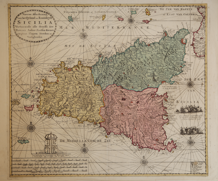
Beautiful and rare nautical chart of Sicily taken from "De Nieuwe Groote Zee-Atlas veermerdeen ..." nautical atlas, published in Amsterdam in about 1718.
Son of the cartographer Johannes van Keulen, Gerard was an engraver and mathematician, cartographer and hydrographer of the East India Company. Oversaw the reissue of his father's works with some corrections and additions. Uncertain is the date of publication of his atlas, which, however, consists of at least 34 editions between 1680 and 1734.
This map of Sicily was certainly engraved after 1718, because it represented the battle of Capo Passero between English and Spanish, which took place in that year. The representation of Sicily has similarities with that by Cantelli published in 1682, while it does consider the corrections of Delisle.
As Hydrographer, van Keulen reports much needed information to mariners, signaling the possible landing sites.
Copper engraving, beautiful original coloring, perfect condition. Very rare.
“Si tratta di una nuova carta nautica della Sicilia eseguita nel laboratorio cartografico dei Van Keulen con la firma e l'imprint editoriale di Gerard (1678-1726): "tot Amsterdam by Gerard van Keulen aan de Nieuwe brugh met Privilegie voor 15 Iaaren". Questa carta non sostituisce quella pubblicata nel 1682 ma compare insieme alla precedente, o in alternativa, ancora per gran parte del '700. A questa carta, che riguarda la sola isola e non anche parte dell'Italia meridonale e della Tunisia, è allegato un foglio con 9 immagini relative a piante e vedute delle principali città della Sicilia: 1) de Haven en Stad Palermo aen de Noord Cust van I. Sicilia (pianta, 124x143); 2) Trapano (veduta, 62x146); 3) Gesigt van de Stadt Messina op Sicilia (veduta, 62x146); 4) Messina (pianta, 124x143); 5) de Stad en Haven Milazzo aan de Noord Cust van Sicilia (pianta, 124x146); 6) de Oost Kust van Sicilia (pianta, 123x143); 7) [pianta di Ca- tania e veduta dell'Etna] (123x146); 8) de Reede en Stad Sergento of Girgenti aen de Zuyd Kust van Eylandt Sici- lia (pianta-profilo costiero, 124x143); 9) de haven en Stad Siracusa aen de Oost Zyde van Sicilia (pianta, 124x146). Le immagini relative a Palermo, Trapani, Messina e Catania, sono tratte da quelle pubblicate da Gabriel Bodenehr nel 1692, la veduta di Trapani risulta invertita. Talvolta le due carte sono congiunte a formare un unico grande foglio di 51x88 cm. Sul lato destro, al largo di Augusta, è rappresentato un combattimento navale con la seguente scritta: "Zee Battalie voorgevallen tussen de Engelsche en Spaansche Vloot op den 11 Augustus A° 1718". Si tratta della famosa battaglia di capo Passero combattuta tra gli inglesi, comandati dall'Ammiraglio Georg Byng (1663-1733), e gli spagnoli di Antonio de Castañeta (1656-1728), durante il periodo di belligeranza per la riconquista della Sicilia da parte degli spagnoli, che l'avevano perduta nel 1713, a seguito del trattato di Utrecht. Questa carta va messa in relazione agli interessi per l'isola suscitati dalle guerre tra la quadruplice alleanza (Inghilterra, Francia, Austria e Olanda) e la Spagna. Sebbene pubblicata per la prima volta in un atlante nel 1728 è probabile che la sua incisione sia stata eseguita in una data prossima alla battaglia navale del 1718 e comunque prima del 1726, anno di morte di Gerard. Va anche notata la stretta somiglianza editoriale (mappa con piante e vedute urbane sui lati) con la carta di Joachim Ottens. Questa edizione della Sicilia di Van Keulen è registrata da Koeman col numero [313].” (Valerio-Spagnolo "Sicilia 1477-1861", p. 395).
Bibliografia:
L. Dufour - A. La Gumina, "Imago Siciliae", p. 182; Valerio-Spagnolo "Sicilia 1477-1861", pp. 395-397, n. 192.
Gerard VAN KEULEN (1678 - 1726)
|
The Van Keulen dynasty of publishers, printers, booksellers, and cartographers produced the most comprehensive and up-to-date Dutch nautical atlases. Johannes van Keulen (1654–1715) founded a book and instrument business in Amsterdam in 1678 and in 1680 obtained the privilege of printing nautical guides and atlases from Holland and West Friesland. His first major work was the Nieuwe Lichtende Zee-Fakkel, illustrated by Jan Luyken, with maps drawn by Claes Jansz Vooght; five volumes were published between 1681 and 1684. Van Keulen also produced a Zee-Atlas ofte Water-werelt. The Van Keulen family continued to operate for nearly two centuries; Gerard (1678 - 1726) produced new editions of his father's works, numerous manuscript maps, and was appointed hydrographer to the Dutch East India Company (VOC) in 1706; his son Jan II van Keulen (1704 - 1770) took over the business in 1726 and published a new edition of the Asiatic volume of the Zee-Atlas; he was appointed cartographer to the VOC in 1743. After Jan II's death, his sons Cornelis Buijs and Gerard Hulst van Keulen ran the family business. Gerard (1733 - 1801) added a further volume to the Zee-Fakkel containing East India material derived from the VOC. Gerard, in addition to publishing the first nautical almanac in Dutch in 1788, was one of the three original members of the commission established by the Dutch government in 1787 to solve the problem of finding longitude at sea. Gerard's son, Jan III, was the last van Keulen to run the company.
|