| Reference: | CO-465 |
| Author | Pierre MORTIER |
| Year: | 1704 ca. |
| Zone: | Radicofani |
| Printed: | Amsterdam |
| Measures: | 475 x 370 mm |
| Reference: | CO-465 |
| Author | Pierre MORTIER |
| Year: | 1704 ca. |
| Zone: | Radicofani |
| Printed: | Amsterdam |
| Measures: | 475 x 370 mm |
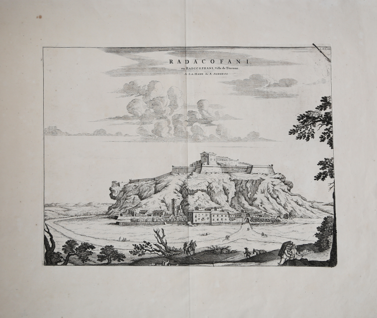
Veduta della rocca e città di Radicofani.
Esemplare tratto dal primo volume del Nouveau Theatre de l'Italie pubblicato ad Amsterdam nel 1704/5 e nel 1724, quale integrazione al progetto di Johannes Baleu, iniziato nel 1663, del grande "libro delle città", manchevole delle piante di gran parte della parte settentrionale della penisola.
Il Blaeu, durante la sua lunga attività editoriale pubblica tre volumi sulle città italiane. Nel 1663 i primi tre, suddivisi in Stato della Chiesa, Roma e Regno di Napoli e Sicilia. Alla sua morte i suoi eredi danno alla luce altri due volumi datati 1682 incentrati sulle città del Piemonte e della Savoia, poi ristampati da altri editori nel 1693 e 1697. Il francese Pierre Mortier pubblica una ristampa nel 1704/5, intitolata “Nouveau Theatre de l’Italie”.
L’opera è in quattro volumi e comprende le lastre del Blaeu, ritoccate e modificate in piccola parte, integrate dall’aggiunta di numerose nuove mappe di proprio disegno, raffiguranti le città della parte settentrionale della penisola, racchiuse nel primo volume dell’opera.
L’atlante del Mortier venne pubblicato con testo latino, francese ed olandese. La particolarità che differenzia le due edizioni di Blaeu e Mortier è rappresentata dal fatto che il testo non è al verso della singola mappa (che quindi è bianca nel retro), ma si trova all’inizio di ogni singolo volume. Il grande successo dell’opera diede origine ad un’ulteriore ristampa, praticamente identica, curata da R. Alberts ed edita nel 1724/5.
Incisione in rame, in buono stato di conservazione.
|
Pierre Mortier (January 26, 1661 - February 18, 1711) or Pieter Mortier was a cartographer, engraver, and print seller active in Amsterdam during the later 17th and early 18th centuries. Mortier, then known as Pieter, was born in Leiden. He relocated to Paris from 1681 to 1685, adopting the French name Pierre, which he retained throughout his career. While in France, he developed deep French connections by bringing sophisticated Dutch printing technology and experience to nascent French map publishers such as Guillaume De L'Isle (1675 - 1726), Alexis-Hubert Jaillot (c. 1632 - 1712), and Nicholas de Fer (1646 - 1720). Consequently, much of Mortier's business was built upon issuing embellished high quality editions of contemporary French maps - generally with the permissions of their original authors. In the greater context of global cartography, this was a significant advantage as most Dutch map publishes had, at this point, fallen into the miasma of reprinting their own outdated works. By contrast, the cartographers of France were producing the most accurate and up to date charts anywhere. Mortier's cartographic work culminated in the magnificent nautical atlas, Le Neptune Francois. He was awarded the Privilege, an early form of copyright, in 1690. Upon Pierre's death in 1711 this business was inherited by his widow. In 1721, his son Cornelius Mortier took over the day to day operation of the firm. Cornelius partnered with his brother-in-law Jean Covens to form one of history's great cartographic partnerships - Covens and Mortier - which continued to publish maps and atlases until about 1866.
|
|
Pierre Mortier (January 26, 1661 - February 18, 1711) or Pieter Mortier was a cartographer, engraver, and print seller active in Amsterdam during the later 17th and early 18th centuries. Mortier, then known as Pieter, was born in Leiden. He relocated to Paris from 1681 to 1685, adopting the French name Pierre, which he retained throughout his career. While in France, he developed deep French connections by bringing sophisticated Dutch printing technology and experience to nascent French map publishers such as Guillaume De L'Isle (1675 - 1726), Alexis-Hubert Jaillot (c. 1632 - 1712), and Nicholas de Fer (1646 - 1720). Consequently, much of Mortier's business was built upon issuing embellished high quality editions of contemporary French maps - generally with the permissions of their original authors. In the greater context of global cartography, this was a significant advantage as most Dutch map publishes had, at this point, fallen into the miasma of reprinting their own outdated works. By contrast, the cartographers of France were producing the most accurate and up to date charts anywhere. Mortier's cartographic work culminated in the magnificent nautical atlas, Le Neptune Francois. He was awarded the Privilege, an early form of copyright, in 1690. Upon Pierre's death in 1711 this business was inherited by his widow. In 1721, his son Cornelius Mortier took over the day to day operation of the firm. Cornelius partnered with his brother-in-law Jean Covens to form one of history's great cartographic partnerships - Covens and Mortier - which continued to publish maps and atlases until about 1866.
|