

| Reference: | S44268 |
| Author | James COOK |
| Year: | 1774 |
| Zone: | South America |
| Measures: | 780 x 475 mm |


| Reference: | S44268 |
| Author | James COOK |
| Year: | 1774 |
| Zone: | South America |
| Measures: | 780 x 475 mm |
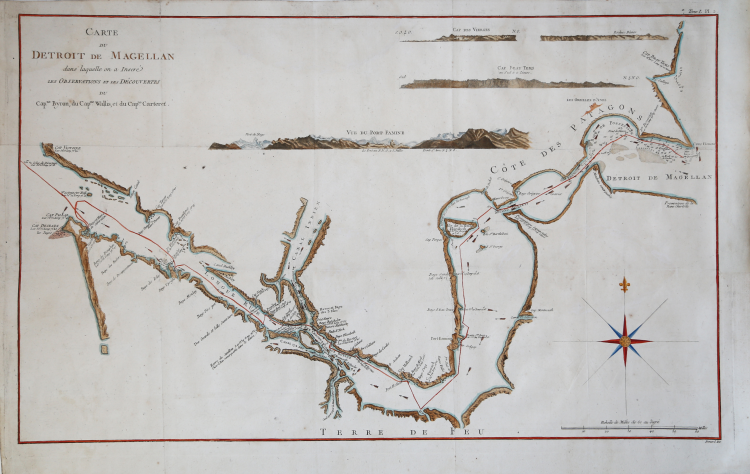
Carte du Detroit de Magellan dans laquelle on a Inseré les observations et de decouvertes du Capne. Byron, du Capne. Wallis, et du Capne. Cateret.
This chart was engraved for inclusion in John Hawkesworth's Relation des voyages entrepris par ordre de Sa Majeste britannique actuellement regnante, in its French edition of 1774.
This 1774 map of the Straits of Magellan reveals the discoveries made by Captains Samuel Wallis (1728-1795) John Byron (1723-1786) and Captain James Cook (1728-1779) during their respective voyages. In compiling the data of these three explorers, Hawkesworth's chart presented the best knowledge of this important and storied passage. This large and boldly engraved piece shows in detail the treacherous coasts of southern Patagonia and of Tierra del Fuego, replete with soundings, channels, anchorages and small islands. Recognition views are provided for Cabo Virgenes, White Cliffs, Cape Fair Weather at the mouth of the Rio Gallego, and A view of Puerto del Hambre. The coastline is full of detail and colorful place names, such as 'Cape Victory' and 'Piss Pot Bay.'
Etching, with fine later hand colour, usual folds, very good condition.
|
Captain James Cook (7 November 1728 - 14 February 1779) is a seminal figure in the history of cartography for which we can offer only a cursory treatment here. Cook began sailing as a teenager in the British Merchant Navy before joining the Royal Navy in 1755. He was posted in America for a time where he worked Samuel Holland, William Bligh, and others in the mapping of the St. Lawrence River and Newfoundland. In 1766 Cook was commissioned to explore the Pacific and given a Captaincy with command of the Endeavour. What followed were three historic voyages of discovery, the highlights of which include the first European contact with eastern Australia, the discovery of the Hawaiian Islands (among many other Polynesian groups), the first circumnavigation of New Zealand, some of the first sightings of Antarctica, the first accurate mapping of the Pacific Northwest, and ultimately his own untimely death at the hands of angry Hawaiians in 1779.
|
|
Captain James Cook (7 November 1728 - 14 February 1779) is a seminal figure in the history of cartography for which we can offer only a cursory treatment here. Cook began sailing as a teenager in the British Merchant Navy before joining the Royal Navy in 1755. He was posted in America for a time where he worked Samuel Holland, William Bligh, and others in the mapping of the St. Lawrence River and Newfoundland. In 1766 Cook was commissioned to explore the Pacific and given a Captaincy with command of the Endeavour. What followed were three historic voyages of discovery, the highlights of which include the first European contact with eastern Australia, the discovery of the Hawaiian Islands (among many other Polynesian groups), the first circumnavigation of New Zealand, some of the first sightings of Antarctica, the first accurate mapping of the Pacific Northwest, and ultimately his own untimely death at the hands of angry Hawaiians in 1779.
|